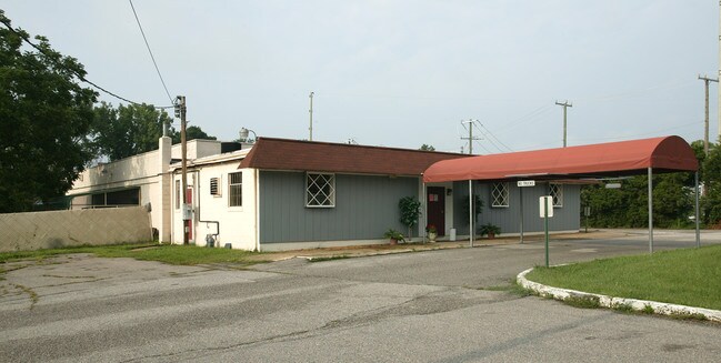
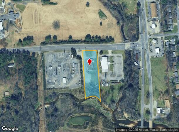
Property Record
1401 Hilliard Rd, Henrico, VA 23228
NEARBY LISTINGS FOR SALE OR LEASE
Property Detail
1401 Hilliard Rd
784-749-4081
00730A0000 0010; S S HILLIARD RD AC 1.618 105 A1 15
Charitableorganization
Henrico
AE
Virginia
5101290027E
1.62 AC
0
Staples Mill/Parham
2025
Richmond VA
200700
Richmond, VA
6,580 SF
DEMOGRAPHICS near 1401 Hilliard Rd
1 Mile
3 Mile
5 Mile
2024 Total Population
6,534
66,905
220,242
2029 Population
6,562
67,688
224,678
Pop Growth 2024-2029
+ 0.43%
+ 1.17%
+ 2.01%
Average Age
41
42
39
2024 Total Households
2,936
29,757
95,251
HH Growth 2024-2029
+ 0.51%
+ 1.42%
+ 2.01%
Median Household Inc
$56,756
$60,257
$68,118
Avg Household Size
2.10
2.20
2.20
2024 Avg HH Vehicles
2.00
2.00
2.00
Median Home Value
$243,214
$260,749
$296,984
Median Year Built
1970
1968
1966
Nearby Places
Map Layers
Map Styles
 Street
 Aerial
- Restaurants
- Banks
- Shops
- Fitness
- Groceries
PUBLIC TRANSPORTATION
COMMUTER RAIL
DRIVE
WALK
Distance
6 min
2.5 mi
DRIVE
WALK
Distance
11 min
7.4 mi
AIRPORT
Richmond International
DRIVE
WALK
Distance
Richmond International
24 min
15.3 mi
Freight Ports
Virginia Port Authority - Richmond
DRIVE
WALK
Distance
Virginia Port Authority - Richmond
22 min
13.6 mi
Nearby Properties
Address
Land Use
TOTAL SIZE
Lot Size
Zoning
Address
Land Use
TOTAL SIZE
Lot Size
Zoning
494,791 SF
38.85 AC
R-6
Address
Land Use
TOTAL SIZE
Lot Size
Zoning
2,645,407 SF
116.30 AC
M2-C
Address
Land Use
TOTAL SIZE
Lot Size
Zoning
43,929 SF
46.83 AC
O-S
Address
Land Use
TOTAL SIZE
Lot Size
Zoning
597,042 SF
41.03 AC
R-6C
Address
Land Use
TOTAL SIZE
Lot Size
Zoning
382,570 SF
2.98 AC
UMUC
Address
Land Use
TOTAL SIZE
Lot Size
Zoning
14.89 AC
R-53 MULTI
Address
Land Use
TOTAL SIZE
Lot Size
Zoning
104,972 SF
108.49 AC
MIXE
Address
Land Use
TOTAL SIZE
Lot Size
Zoning
16.14 AC
MULTIPLE Z
Address
Land Use
TOTAL SIZE
Lot Size
Zoning
321,552 SF
UMUC
Address
Land Use
TOTAL SIZE
Lot Size
Zoning
2.11 AC
M-1
Address
Land Use
TOTAL SIZE
Lot Size
Zoning
1,404 SF
30.52 AC
R-5
Address
Land Use
TOTAL SIZE
Lot Size
Zoning
224,768 SF
18.08 AC
R-6
Address
Land Use
TOTAL SIZE
Lot Size
Zoning
59,574 SF
313.03 AC
MIXE
Address
Land Use
TOTAL SIZE
Lot Size
Zoning
110,790 SF
37.61 AC
R-2A
Address
Land Use
TOTAL SIZE
Lot Size
Zoning
180,070 SF
17.13 AC
R-5
Address
Land Use
TOTAL SIZE
Lot Size
Zoning
102,942 SF
71.86 AC
MIXE
Address
Land Use
TOTAL SIZE
Lot Size
Zoning
104,023 SF
98.16 AC
MIXE
Address
Land Use
TOTAL SIZE
Lot Size
Zoning
308,878 SF
5.94 AC
B-3C
Address
Land Use
TOTAL SIZE
Lot Size
Zoning
213,344 SF
16.28 AC
R-5
Address
Land Use
TOTAL SIZE
Lot Size
Zoning
100 SF
11.56 AC
R-53 MULTI
Address
Land Use
TOTAL SIZE
Lot Size
Zoning
24,165 SF
72.13 AC
C-1
Address
Land Use
TOTAL SIZE
Lot Size
Zoning
226,400 SF
14.70 AC
R-5
Address
Land Use
TOTAL SIZE
Lot Size
Zoning
254,997 SF
21.25 AC
B-3C
Address
Land Use
TOTAL SIZE
Lot Size
Zoning
332,465 SF
19.11 AC
M-1
Address
Land Use
TOTAL SIZE
Lot Size
Zoning
62,919 SF
17.87 AC
R-3
Address
Land Use
TOTAL SIZE
Lot Size
Zoning
251,400 SF
16.18 AC
R-6C
Address
Land Use
TOTAL SIZE
Lot Size
Zoning
177,810 SF
0.01 AC
R-6C
Address
Land Use
TOTAL SIZE
Lot Size
Zoning
45,308 SF
13.59 AC
M-1
Address
Land Use
TOTAL SIZE
Lot Size
Zoning
274,284 SF
0.02 AC
R-6C
Address
Land Use
TOTAL SIZE
Lot Size
Zoning
138,140 SF
7.66 AC
R-6
The World's #1 Commercial Real Estate Marketplace
Connect with us
© 2025 CoStar Group
The information above has been obtained from sources believed reliable. While we do not doubt its accuracy we have not verified it and make no guarantee, warranty or representation about it. It is your responsibility to independently confirm its accuracy and completeness. Any projections, opinions, assumptions, or estimates used are for example only and do not represent the current or future performance of the property. The value of this transaction to you depends on tax and other factors which should be evaluated by your tax, financial, and legal advisors. You and your advisors should conduct a careful, independent investigation of the property to determine to your satisfaction the suitability of the property for your needs.