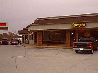
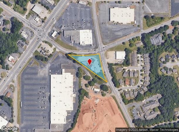
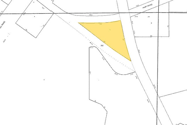
Property Record
1401 Hurt Rd, Austell, GA 30106
NEARBY LISTINGS FOR SALE OR LEASE
Property Detail
1401 Hurt Rd
19-0855-0-001-0
West Cobb Joint Venture
Supermarket
Cobb
X
Georgia
13067C0201G
855
2025
1.14 AC
2025
Powder Spring/Austell
031412
Atlanta
6,023 SF
Atlanta-Sandy Springs-Roswell, GA
DEMOGRAPHICS near 1401 Hurt Rd
1 Mile
3 Mile
5 Mile
2024 Total Population
9,987
72,003
190,422
2029 Population
10,168
73,124
193,617
Pop Growth 2024-2029
+ 1.81%
+ 1.56%
+ 1.68%
Average Age
39
39
38
2024 Total Households
3,877
26,032
69,380
HH Growth 2024-2029
+ 1.68%
+ 1.49%
+ 1.65%
Median Household Inc
$59,988
$74,106
$73,368
Avg Household Size
2.50
2.70
2.70
2024 Avg HH Vehicles
2.00
2.00
2.00
Median Home Value
$247,151
$264,671
$279,612
Median Year Built
1991
1985
1984
Nearby Places
Map Layers
Map Styles
 Street
 Aerial
- Restaurants
- Banks
- Shops
- Fitness
- Groceries
PUBLIC TRANSPORTATION
AIRPORT
Hartsfield - Jackson Atlanta International
DRIVE
WALK
Distance
Hartsfield - Jackson Atlanta International
41 min
26.3 mi
Nearby Properties
Address
Land Use
TOTAL SIZE
Lot Size
Zoning
Address
Land Use
TOTAL SIZE
Lot Size
Zoning
494,972 SF
25.60 AC
CF
Address
Land Use
TOTAL SIZE
Lot Size
Zoning
403,898 SF
37.53 AC
RM-12
Address
Land Use
TOTAL SIZE
Lot Size
Zoning
370,201 SF
28.35 AC
RM-12
Address
Land Use
TOTAL SIZE
Lot Size
Zoning
25,956 SF
12.78 AC
PVC
Address
Land Use
TOTAL SIZE
Lot Size
Zoning
272,170 SF
26.40 AC
RM-12
Address
Land Use
TOTAL SIZE
Lot Size
Zoning
488,748 SF
32.28 AC
RM-12
Address
Land Use
TOTAL SIZE
Lot Size
Zoning
238,984 SF
17.51 AC
RM-12
Address
Land Use
TOTAL SIZE
Lot Size
Zoning
148,612 SF
12.65 AC
RM-12
Address
Land Use
TOTAL SIZE
Lot Size
Zoning
209,649 SF
13.51 AC
RM-12
Address
Land Use
TOTAL SIZE
Lot Size
Zoning
345,192 SF
22.67 AC
RM-12
Address
Land Use
TOTAL SIZE
Lot Size
Zoning
219,402 SF
10.33 AC
RM-12
Address
Land Use
TOTAL SIZE
Lot Size
Zoning
179,048 SF
25.97 AC
RM-12
Address
Land Use
TOTAL SIZE
Lot Size
Zoning
250,482 SF
16.74 AC
RM-12
Address
Land Use
TOTAL SIZE
Lot Size
Zoning
118,069 SF
0.38 AC
OI
Address
Land Use
TOTAL SIZE
Lot Size
Zoning
188,988 SF
15.30 AC
OI
Address
Land Use
TOTAL SIZE
Lot Size
Zoning
3.46 AC
RM-12
Address
Land Use
TOTAL SIZE
Lot Size
Zoning
161,927 SF
7.95 AC
OI
Address
Land Use
TOTAL SIZE
Lot Size
Zoning
198,052 SF
24.52 AC
NRC/CRC
Address
Land Use
TOTAL SIZE
Lot Size
Zoning
109,072 SF
15.23 AC
NRC
Address
Land Use
TOTAL SIZE
Lot Size
Zoning
92,468 SF
13.69 AC
RM-8
Address
Land Use
TOTAL SIZE
Lot Size
Zoning
78.60 AC
R20
Address
Land Use
TOTAL SIZE
Lot Size
Zoning
83,314 SF
15.74 AC
NRC
Address
Land Use
TOTAL SIZE
Lot Size
Zoning
98,574 SF
10.27 AC
CRC
Address
Land Use
TOTAL SIZE
Lot Size
Zoning
170,892 SF
29.16 AC
CRC/LRO
Address
Land Use
TOTAL SIZE
Lot Size
Zoning
89,686 SF
10.60 AC
NRC
Address
Land Use
TOTAL SIZE
Lot Size
Zoning
2.76 AC
NRC
Address
Land Use
TOTAL SIZE
Lot Size
Zoning
80,552 SF
10.94 AC
GC/WS
Address
Land Use
TOTAL SIZE
Lot Size
Zoning
134,592 SF
13.43 AC
CBD
Address
Land Use
TOTAL SIZE
Lot Size
Zoning
2,636 SF
2.97 AC
NRC
Address
Land Use
TOTAL SIZE
Lot Size
Zoning
104,538 SF
9.18 AC
RM-12
The World's #1 Commercial Real Estate Marketplace
Connect with us
© 2026 CoStar Group
The information above has been obtained from sources believed reliable. While we do not doubt its accuracy we have not verified it and make no guarantee, warranty or representation about it. It is your responsibility to independently confirm its accuracy and completeness. Any projections, opinions, assumptions, or estimates used are for example only and do not represent the current or future performance of the property. The value of this transaction to you depends on tax and other factors which should be evaluated by your tax, financial, and legal advisors. You and your advisors should conduct a careful, independent investigation of the property to determine to your satisfaction the suitability of the property for your needs.