Property Record
1401 Mount Hermon Rd, Salisbury, MD 21804


Save to a Folder
{{folder.Name}}
{{folder.ListingIds.length}} Properties
{{folder.ListingIds.length}} Property
Create a New Folder
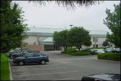
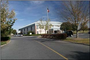
Property Detail
1401 Mount Hermon Rd
05-103460
LOT 8-3.22 AC 1401 MT HERMON RD MT HERMON EXEC PLAZA
Officebuilding
Wicomico
LBI
Maryland
B and X Area of moderate flood hazard, usually the area between the limits of the 100-year and 500-year floods.
8
2025
3.22 AC
2025
Other Market Areas
010102
Salisbury, MD
33,880 SF
NEARBY LISTINGS FOR SALE OR LEASE
DEMOGRAPHICS near 1401 Mount Hermon Rd
1 mile
3 mile
5 mile
2025 Total Population
7,037
47,541
73,297
2030 Population
7,205
48,771
75,102
Pop Growth 2025-2030
+ 2.39%
+ 2.59%
+ 2.46%
Average Age
40
37
38
2025 Total Households
2,972
18,864
28,373
HH Growth 2025-2030
+ 2.49%
+ 2.65%
+ 2.54%
Median Household Inc
$73,632
$58,557
$67,127
Avg Household Size
2.30
2.40
2.40
2025 Avg HH Vehicles
2.00
2.00
2.00
Median Home Value
$220,048
$225,769
$249,116
Median Year Built
1979
1976
1980
Nearby Places
Map Layers
Map Styles
 Street
 Aerial
Layers
 Traffic
 Biking
Places
Listings with unknown addresses are not visible on the map
- Restaurants
- Banks
- Shops
- Fitness
- Groceries
PUBLIC TRANSPORTATION
AIRPORT
Salisbury-Ocean City Wicomico Regional
Drive
Walk
Distance
Salisbury-Ocean City Wicomico Regional
11 min
5.1 mi
Freight Ports
Port of Baltimore
Drive
Walk
Distance
Port of Baltimore
157 min
108.3 mi
Nearby Properties
Address
Land Use
TOTAL SIZE
Lot Size
Zoning
Address
Land Use
TOTAL SIZE
Lot Size
Zoning
1,792 SF
76.32 AC
R20
Address
Land Use
TOTAL SIZE
Lot Size
Zoning
602,336 SF
22.69 AC
H
Address
Land Use
TOTAL SIZE
Lot Size
Zoning
18,951 SF
35.15 AC
R8
Address
Land Use
TOTAL SIZE
Lot Size
Zoning
28,442 SF
34.88 AC
GC
Address
Land Use
TOTAL SIZE
Lot Size
Zoning
208,457 SF
3.05 AC
C
Address
Land Use
TOTAL SIZE
Lot Size
Zoning
32,100 SF
22.32 AC
LI
Address
Land Use
TOTAL SIZE
Lot Size
Zoning
118,330 SF
1.99 AC
CBD
Address
Land Use
TOTAL SIZE
Lot Size
Zoning
103,992 SF
0.59 AC
CBD
Address
Land Use
TOTAL SIZE
Lot Size
Zoning
160,552 SF
15.48 AC
Address
Land Use
TOTAL SIZE
Lot Size
Zoning
20,850 SF
12.08 AC
CU
Address
Land Use
TOTAL SIZE
Lot Size
Zoning
164,178 SF
55.53 AC
R5A
Address
Land Use
TOTAL SIZE
Lot Size
Zoning
219,584 SF
23.60 AC
PRD
Address
Land Use
TOTAL SIZE
Lot Size
Zoning
4,093 SF
75.38 AC
R8
Address
Land Use
TOTAL SIZE
Lot Size
Zoning
14,988 SF
7.51 AC
R8A
Address
Land Use
TOTAL SIZE
Lot Size
Zoning
98,193 SF
16.16 AC
LB 1
Address
Land Use
TOTAL SIZE
Lot Size
Zoning
15,180 SF
15.20 AC
LBIR8
Address
Land Use
TOTAL SIZE
Lot Size
Zoning
488,450 SF
28.70 AC
GC
Address
Land Use
TOTAL SIZE
Lot Size
Zoning
14,614 SF
17.23 AC
R8A
Address
Land Use
TOTAL SIZE
Lot Size
Zoning
105,626 SF
53.26 AC
R-8
Address
Land Use
TOTAL SIZE
Lot Size
Zoning
12,024 SF
12.98 AC
R5A
Address
Land Use
TOTAL SIZE
Lot Size
Zoning
28,365 SF
11.21 AC
R1A
Address
Land Use
TOTAL SIZE
Lot Size
Zoning
15,531 SF
15.26 AC
GC
Address
Land Use
TOTAL SIZE
Lot Size
Zoning
22,431 SF
8.74 AC
R10
Address
Land Use
TOTAL SIZE
Lot Size
Zoning
5,760 SF
12.09 AC
LBI
Address
Land Use
TOTAL SIZE
Lot Size
Zoning
6,136 SF
52.49 AC
R-10
Address
Land Use
TOTAL SIZE
Lot Size
Zoning
36.64 AC
C3
Address
Land Use
TOTAL SIZE
Lot Size
Zoning
1,804 SF
1,046 AC
AIRPT
Address
Land Use
TOTAL SIZE
Lot Size
Zoning
33,900 SF
4.24 AC
LBI
Address
Land Use
TOTAL SIZE
Lot Size
Zoning
19,608 SF
4.99 AC
CU
Address
Land Use
TOTAL SIZE
Lot Size
Zoning
76,999 SF
7.72 AC
R-8
The World's #1 Commercial Real Estate Marketplace
Connect with us
© 2026 CoStar Group
The information above has been obtained from sources believed reliable. While we do not doubt its accuracy we have not verified it and make no guarantee, warranty or representation about it. It is your responsibility to independently confirm its accuracy and completeness. Any projections, opinions, assumptions, or estimates used are for example only and do not represent the current or future performance of the property. The value of this transaction to you depends on tax and other factors which should be evaluated by your tax, financial, and legal advisors. You and your advisors should conduct a careful, independent investigation of the property to determine to your satisfaction the suitability of the property for your needs.