Property Record
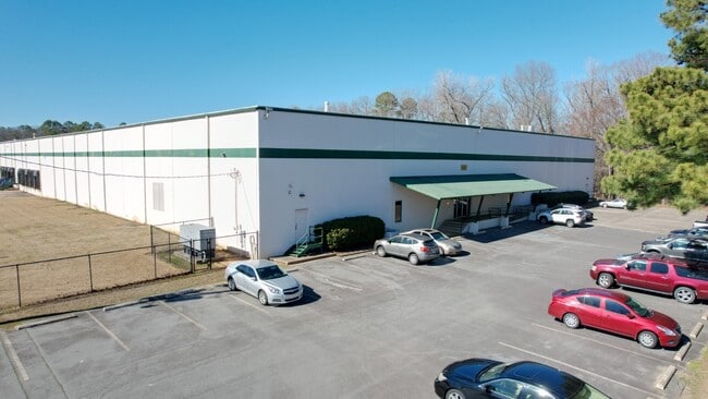
1401 Murphy Dr, Maumelle, AR 72113


Property Detail
1401 Murphy Dr
42M-009-00-007-00
Pulaski
Warehouse
Arkansas
B and X Area of moderate flood hazard, usually the area between the limits of the 100-year and 500-year floods.
25
2025
10.69 AC
2025
Outlying Pulaski County
004309
Little Rock/N Little Rock
160,000 SF
Little Rock-North Little Rock-Conway, AR
NEARBY LISTINGS FOR SALE OR LEASE
DEMOGRAPHICS near 1401 Murphy Dr
1 mile
3 mile
5 mile
2025 Total Population
4,523
25,516
32,605
2030 Population
4,498
25,553
32,698
Pop Growth 2025-2030
(0.55%)
+ 0.15%
+ 0.29%
Average Age
38
40
40
2025 Total Households
1,914
10,989
14,164
HH Growth 2025-2030
(0.57%)
+ 0.28%
+ 0.39%
Median Household Inc
$85,077
$74,763
$72,236
Avg Household Size
2.30
2.30
2.30
2025 Avg HH Vehicles
2.00
2.00
2.00
Median Home Value
$209,537
$292,558
$289,409
Median Year Built
1988
2001
2000
Nearby Places
Map Layers
Map Styles
 Street
 Aerial
Layers
 Traffic
 Biking
Places
Listings with unknown addresses are not visible on the map
- Restaurants
- Banks
- Shops
- Fitness
- Groceries
PUBLIC TRANSPORTATION
AIRPORT
Bill and Hillary Clinton Ntl/Adams Field
Drive
Walk
Distance
Bill and Hillary Clinton Ntl/Adams Field
26 min
19.5 mi
Freight Ports
Port of Shreveport
Drive
Walk
Distance
Port of Shreveport
260 min
241.9 mi
SALE & LEASE HISTORY
LISTING DATE
SALE/LEASE

Feb 28, 2025
For Sale
Nearby Properties
Address
Land Use
TOTAL SIZE
Lot Size
Zoning
Address
Land Use
TOTAL SIZE
Lot Size
Zoning
1,160,360 SF
119.55 AC
Address
Land Use
TOTAL SIZE
Lot Size
Zoning
28,414 SF
80.25 AC
Address
Land Use
TOTAL SIZE
Lot Size
Zoning
320,000 SF
91.54 AC
Address
Land Use
TOTAL SIZE
Lot Size
Zoning
89,847 SF
12.77 AC
Address
Land Use
TOTAL SIZE
Lot Size
Zoning
35,712 SF
19.92 AC
Address
Land Use
TOTAL SIZE
Lot Size
Zoning
55,997 SF
11.51 AC
Address
Land Use
TOTAL SIZE
Lot Size
Zoning
83,352 SF
6.90 AC
Address
Land Use
TOTAL SIZE
Lot Size
Zoning
77,478 SF
38.22 AC
Address
Land Use
TOTAL SIZE
Lot Size
Zoning
18,904 SF
12.73 AC
Address
Land Use
TOTAL SIZE
Lot Size
Zoning
12,077 SF
27.97 AC
Address
Land Use
TOTAL SIZE
Lot Size
Zoning
484,932 SF
32.85 AC
Address
Land Use
TOTAL SIZE
Lot Size
Zoning
157,500 SF
54.99 AC
Address
Land Use
TOTAL SIZE
Lot Size
Zoning
2,340 SF
37.56 AC
Address
Land Use
TOTAL SIZE
Lot Size
Zoning
192,104 SF
34.51 AC
Address
Land Use
TOTAL SIZE
Lot Size
Zoning
139,444 SF
7.63 AC
Address
Land Use
TOTAL SIZE
Lot Size
Zoning
8,624 SF
10.37 AC
Address
Land Use
TOTAL SIZE
Lot Size
Zoning
188,528 SF
24.29 AC
Address
Land Use
TOTAL SIZE
Lot Size
Zoning
66,619 SF
5.89 AC
Address
Land Use
TOTAL SIZE
Lot Size
Zoning
56,423 SF
Address
Land Use
TOTAL SIZE
Lot Size
Zoning
8,417 SF
101 AC
Address
Land Use
TOTAL SIZE
Lot Size
Zoning
12,346 SF
14.41 AC
Address
Land Use
TOTAL SIZE
Lot Size
Zoning
38,369 SF
10.04 AC
Address
Land Use
TOTAL SIZE
Lot Size
Zoning
60,966 SF
21.82 AC
Address
Land Use
TOTAL SIZE
Lot Size
Zoning
6,357 SF
10.80 AC
Address
Land Use
TOTAL SIZE
Lot Size
Zoning
37,955 SF
2.45 AC
Address
Land Use
TOTAL SIZE
Lot Size
Zoning
840 SF
20.01 AC
Address
Land Use
TOTAL SIZE
Lot Size
Zoning
83,647 SF
11.60 AC
Address
Land Use
TOTAL SIZE
Lot Size
Zoning
71,132 SF
5.89 AC
Address
Land Use
TOTAL SIZE
Lot Size
Zoning
162,010 SF
10.45 AC
Address
Land Use
TOTAL SIZE
Lot Size
Zoning
90,746 SF
5.84 AC
The World's #1 Commercial Real Estate Marketplace
Connect with us
© 2026 CoStar Group
The information above has been obtained from sources believed reliable. While we do not doubt its accuracy we have not verified it and make no guarantee, warranty or representation about it. It is your responsibility to independently confirm its accuracy and completeness. Any projections, opinions, assumptions, or estimates used are for example only and do not represent the current or future performance of the property. The value of this transaction to you depends on tax and other factors which should be evaluated by your tax, financial, and legal advisors. You and your advisors should conduct a careful, independent investigation of the property to determine to your satisfaction the suitability of the property for your needs.