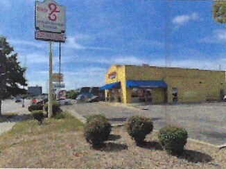
Property Record
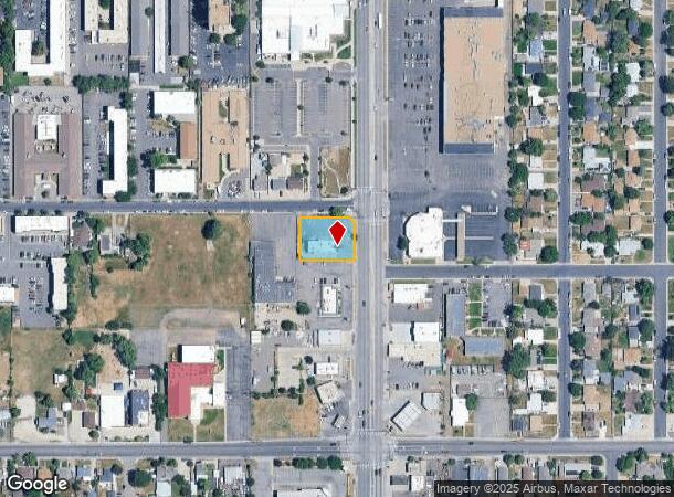
1401 S Federal Blvd, Denver, CO 80219
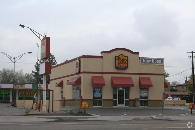

This Property Is For Sale
Current Lease Availabilities
NEARBY LISTINGS FOR SALE OR LEASE
Property Detail
1401 S Federal Blvd
Denver-Aurora-Lakewood, CO
Garfield Hts New
5202-12-043
GARFIELD HTS NEW FLG PLOT 37 E 150FT
Restaurantbuilding
Denver
X
Colorado
0800460184J
37
2024
0.43 AC
2024
West
004602
Denver
2,678 SF
DEMOGRAPHICS near 1401 S Federal Blvd
1 Mile
3 Mile
5 Mile
2024 Total Population
24,164
163,367
480,383
2029 Population
24,101
163,232
484,373
Pop Growth 2024-2029
(0.26%)
(0.08%)
+ 0.83%
Average Age
37
38
39
2024 Total Households
7,816
63,195
224,304
HH Growth 2024-2029
(0.51%)
(0.15%)
+ 1.00%
Median Household Inc
$57,546
$70,331
$77,929
Avg Household Size
2.90
2.50
2.00
2024 Avg HH Vehicles
2.00
2.00
2.00
Median Home Value
$365,290
$439,320
$557,147
Median Year Built
1956
1958
1970
Nearby Places
- Restaurants
- Banks
- Shops
- Fitness
- Groceries
PUBLIC TRANSPORTATION
COMMUTER RAIL
Union Station: Lodo-Coors Field-16Th Street Mall (C Line - Denver Regional Transportation District Light Rail (TheRide), E Line - Denver Regional Transportation District Light Rail (TheRide), W Line - Denver Regional Transportation District Light Rail (TheRide))
DRIVE
WALK
Distance
Union Station: Lodo-Coors Field-16Th Street Mall (C Line - Denver Regional Transportation District Light Rail (TheRide), E Line - Denver Regional Transportation District Light Rail (TheRide), W Line - Denver Regional Transportation District Light Rail (TheRide))
12 min
5.4 mi
Denver (California Zephyr - Amtrak)
DRIVE
WALK
Distance
Denver (California Zephyr - Amtrak)
12 min
5.6 mi
AIRPORT
Denver International
DRIVE
WALK
Distance
Denver International
41 min
29.6 mi
Freight Ports
Tulsa Port Of Catoosa
DRIVE
WALK
Distance
Tulsa Port Of Catoosa
738 min
715.1 mi
Nearby Properties
Address
Land Use
TOTAL SIZE
Lot Size
Zoning
Address
Land Use
TOTAL SIZE
Lot Size
Zoning
113,932 SF
9.60 AC
I-B
Address
Land Use
TOTAL SIZE
Lot Size
Zoning
323,426 SF
29.84 AC
I-B
Address
Land Use
TOTAL SIZE
Lot Size
Zoning
362,988 SF
4.71 AC
T-MU-30
Address
Land Use
TOTAL SIZE
Lot Size
Zoning
356,004 SF
4.59 AC
C-MX-12
Address
Land Use
TOTAL SIZE
Lot Size
Zoning
341,493 SF
4.22 AC
T-MU-30
Address
Land Use
TOTAL SIZE
Lot Size
Zoning
533,298 SF
3.23 AC
C-MX
Address
Land Use
TOTAL SIZE
Lot Size
Zoning
304,560 SF
23.94 AC
S-SU-F
Address
Land Use
TOTAL SIZE
Lot Size
Zoning
381 SF
66.05 AC
I-B
Address
Land Use
TOTAL SIZE
Lot Size
Zoning
310,910 SF
2.68 AC
C-MX-16
Address
Land Use
TOTAL SIZE
Lot Size
Zoning
208,529 SF
34.81 AC
R-5
Address
Land Use
TOTAL SIZE
Lot Size
Zoning
67,603 SF
24.89 AC
I-B
Address
Land Use
TOTAL SIZE
Lot Size
Zoning
288,570 SF
2.57 AC
C-MX-16
Address
Land Use
TOTAL SIZE
Lot Size
Zoning
307,325 SF
5.35 AC
C-RX-5
Address
Land Use
TOTAL SIZE
Lot Size
Zoning
368,527 SF
18.71 AC
S-SU-D
Address
Land Use
TOTAL SIZE
Lot Size
Zoning
33,500 SF
53.33 AC
Address
Land Use
TOTAL SIZE
Lot Size
Zoning
167,910 SF
6.89 AC
U-RH-2.5
Address
Land Use
TOTAL SIZE
Lot Size
Zoning
472,235 SF
1.98 AC
C-RX
Address
Land Use
TOTAL SIZE
Lot Size
Zoning
296,778 SF
2.28 AC
U-MS
Address
Land Use
TOTAL SIZE
Lot Size
Zoning
339,907 SF
11.18 AC
I-A
Address
Land Use
TOTAL SIZE
Lot Size
Zoning
324,531 SF
14.97 AC
I-A
Address
Land Use
TOTAL SIZE
Lot Size
Zoning
239,840 SF
3.11 AC
T-MU-30
Address
Land Use
TOTAL SIZE
Lot Size
Zoning
236,250 SF
2.22 AC
C-MX-5
Address
Land Use
TOTAL SIZE
Lot Size
Zoning
174,850 SF
17.21 AC
I-A
Address
Land Use
TOTAL SIZE
Lot Size
Zoning
6.84 AC
C-MX-12
Address
Land Use
TOTAL SIZE
Lot Size
Zoning
298,427 SF
6.80 AC
C-MX-12
Address
Land Use
TOTAL SIZE
Lot Size
Zoning
90,609 SF
3.63 AC
G-MU-3
Address
Land Use
TOTAL SIZE
Lot Size
Zoning
297,776 SF
2.88 AC
C-MX
Address
Land Use
TOTAL SIZE
Lot Size
Zoning
229,830 SF
11.33 AC
Address
Land Use
TOTAL SIZE
Lot Size
Zoning
180,689 SF
2.67 AC
I-A
Address
Land Use
TOTAL SIZE
Lot Size
Zoning
258,980 SF
16.55 AC
PUD
The World's #1 Commercial Real Estate Marketplace
Connect with us
© 2025 CoStar Group
The information above has been obtained from sources believed reliable. While we do not doubt its accuracy we have not verified it and make no guarantee, warranty or representation about it. It is your responsibility to independently confirm its accuracy and completeness. Any projections, opinions, assumptions, or estimates used are for example only and do not represent the current or future performance of the property. The value of this transaction to you depends on tax and other factors which should be evaluated by your tax, financial, and legal advisors. You and your advisors should conduct a careful, independent investigation of the property to determine to your satisfaction the suitability of the property for your needs.