Property Record
1401 Saint Stephens Rd, Prichard, AL 36610


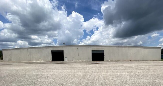
Property Detail
1401 Saint Stephens Rd
Mobile, AL
Industrial Site
29-02-44-0-008-189.002
COM AT NW COR OF LOT 10 R1W OWEN DIV OF ST LOUIS TRT RUN S 35 DEG 39 MIN 00 SEC E ALG E/L OF OWEN ST (30 FT R/W) A DIS 402.7
Warehouse
Mobile
X
Alabama
01097C0551L
10,52
2025
4.06 AC
2025
Prichard/Saraland
003901
Mobile
105,000 SF
NEARBY LISTINGS FOR SALE OR LEASE
DEMOGRAPHICS near 1401 Saint Stephens Rd
1 mile
3 mile
5 mile
2024 Total Population
9,290
52,504
113,554
2029 Population
9,582
53,396
114,135
Pop Growth 2024-2029
+ 3.14%
+ 1.70%
+ 0.51%
Average Age
42
41
40
2024 Total Households
3,775
20,910
46,891
HH Growth 2024-2029
+ 3.23%
+ 1.83%
+ 0.52%
Median Household Inc
$31,531
$35,147
$40,973
Avg Household Size
2.30
2.30
2.30
2024 Avg HH Vehicles
2.00
2.00
2.00
Median Home Value
$60,335
$76,693
$121,003
Median Year Built
1966
1966
1966
Nearby Places
Map Layers
Map Styles
 Street
 Aerial
Transit
 Traffic
 Biking
Places
Listings with unknown addresses are not visible on the map
- Restaurants
- Banks
- Shops
- Fitness
- Groceries
PUBLIC TRANSPORTATION
AIRPORT
Mobile International
Drive
Walk
Distance
Mobile International
18 min
7.9 mi
Mobile Regional
Drive
Walk
Distance
Mobile Regional
27 min
14.2 mi
Freight Ports
Port of Mobile
Drive
Walk
Distance
Port of Mobile
10 min
5.2 mi
SALE & LEASE HISTORY
LISTING DATE
SALE/LEASE

Jul 15, 2020
For Sale
Dec 03, 2020
For Lease
Nearby Properties
Address
Land Use
TOTAL SIZE
Lot Size
Zoning
Address
Land Use
TOTAL SIZE
Lot Size
Zoning
171,670 SF
20.19 AC
Address
Land Use
TOTAL SIZE
Lot Size
Zoning
339,141 SF
7.18 AC
Address
Land Use
TOTAL SIZE
Lot Size
Zoning
141,209 SF
10.20 AC
Address
Land Use
TOTAL SIZE
Lot Size
Zoning
30,504 SF
16.45 AC
Address
Land Use
TOTAL SIZE
Lot Size
Zoning
200,370 SF
47.96 AC
Address
Land Use
TOTAL SIZE
Lot Size
Zoning
91,391 SF
14.93 AC
Address
Land Use
TOTAL SIZE
Lot Size
Zoning
12.97 AC
Address
Land Use
TOTAL SIZE
Lot Size
Zoning
103,308 SF
34 AC
Address
Land Use
TOTAL SIZE
Lot Size
Zoning
15,960 SF
11.06 AC
Address
Land Use
TOTAL SIZE
Lot Size
Zoning
143,067 SF
9.62 AC
Address
Land Use
TOTAL SIZE
Lot Size
Zoning
142,431 SF
10.12 AC
Address
Land Use
TOTAL SIZE
Lot Size
Zoning
5,553 SF
40.77 AC
Address
Land Use
TOTAL SIZE
Lot Size
Zoning
97,443 SF
98.83 AC
Address
Land Use
TOTAL SIZE
Lot Size
Zoning
107,777 SF
8.87 AC
Address
Land Use
TOTAL SIZE
Lot Size
Zoning
99,856 SF
33 AC
Address
Land Use
TOTAL SIZE
Lot Size
Zoning
37,209 SF
8.75 AC
Address
Land Use
TOTAL SIZE
Lot Size
Zoning
40,590 SF
9.30 AC
Address
Land Use
TOTAL SIZE
Lot Size
Zoning
131,516 SF
15 AC
Address
Land Use
TOTAL SIZE
Lot Size
Zoning
53,850 SF
12 AC
Address
Land Use
TOTAL SIZE
Lot Size
Zoning
66,025 SF
9.70 AC
Address
Land Use
TOTAL SIZE
Lot Size
Zoning
94,787 SF
18 AC
Address
Land Use
TOTAL SIZE
Lot Size
Zoning
12,520 SF
5.92 AC
Address
Land Use
TOTAL SIZE
Lot Size
Zoning
77,123 SF
10 AC
Address
Land Use
TOTAL SIZE
Lot Size
Zoning
105,627 SF
7.91 AC
Address
Land Use
TOTAL SIZE
Lot Size
Zoning
69,338 SF
8.23 AC
Address
Land Use
TOTAL SIZE
Lot Size
Zoning
58,452 SF
5.08 AC
Address
Land Use
TOTAL SIZE
Lot Size
Zoning
Address
Land Use
TOTAL SIZE
Lot Size
Zoning
52,260 SF
6.62 AC
Address
Land Use
TOTAL SIZE
Lot Size
Zoning
14,784 SF
6.12 AC
Address
Land Use
TOTAL SIZE
Lot Size
Zoning
41,928 SF
29.40 AC
The World's #1 Commercial Real Estate Marketplace
Connect with us
© 2026 CoStar Group
The information above has been obtained from sources believed reliable. While we do not doubt its accuracy we have not verified it and make no guarantee, warranty or representation about it. It is your responsibility to independently confirm its accuracy and completeness. Any projections, opinions, assumptions, or estimates used are for example only and do not represent the current or future performance of the property. The value of this transaction to you depends on tax and other factors which should be evaluated by your tax, financial, and legal advisors. You and your advisors should conduct a careful, independent investigation of the property to determine to your satisfaction the suitability of the property for your needs.