Property Record
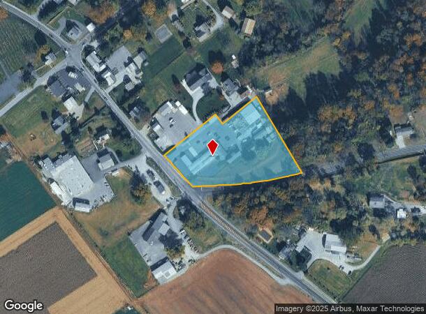
1401 W Kings Hwy, Gap, PA 17527

NEARBY LISTINGS FOR SALE OR LEASE
Property Detail
1401 W Kings Hwy
Philadelphia-Camden-Wilmington, PA-NJ-DE-MD
Amos L Petersheim
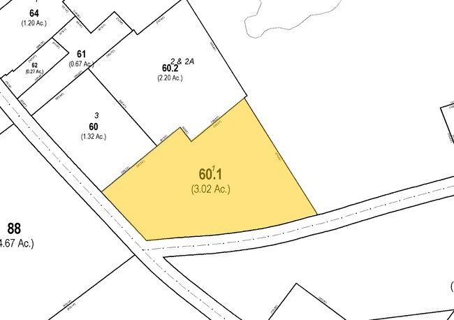
28-004-0060.0100
3.23 AC DWG BARN & STORE L
Commercialnec
Chester
X
Pennsylvania
42029C0125G
1
2024
3.23 AC
2025
Outer Chester County
305102
Philadelphia
16,759 SF
DEMOGRAPHICS near 1401 W Kings Hwy
1 Mile
3 Mile
5 Mile
2024 Total Population
874
8,224
29,717
2029 Population
901
8,435
30,420
Pop Growth 2024-2029
+ 3.09%
+ 2.57%
+ 2.37%
Average Age
40
41
40
2024 Total Households
289
2,738
10,224
HH Growth 2024-2029
+ 3.11%
+ 2.70%
+ 2.57%
Median Household Inc
$104,861
$91,304
$94,665
Avg Household Size
2.90
2.90
2.80
2024 Avg HH Vehicles
2.00
2.00
2.00
Median Home Value
$338,405
$332,680
$311,111
Median Year Built
1994
1990
1986
Nearby Places
Map Layers
Map Styles
 Street
 Aerial
- Restaurants
- Banks
- Shops
- Fitness
- Groceries
PUBLIC TRANSPORTATION
COMMUTER RAIL
Parkesburg Amtrak (Keystone Service - Amtrak)
DRIVE
WALK
Distance
Parkesburg Amtrak (Keystone Service - Amtrak)
12 min
5.5 mi
Coatesville Amtrak (Keystone Service - Amtrak)
DRIVE
WALK
Distance
Coatesville Amtrak (Keystone Service - Amtrak)
15 min
9.0 mi
Freight Ports
Port of Wilmington, RI
DRIVE
WALK
Distance
Port of Wilmington, RI
67 min
37.8 mi
Nearby Properties
Address
Land Use
TOTAL SIZE
Lot Size
Zoning
Address
Land Use
TOTAL SIZE
Lot Size
Zoning
400,038 SF
67.45 AC
C2
Address
Land Use
TOTAL SIZE
Lot Size
Zoning
41,658 SF
5.62 AC
C2
Address
Land Use
TOTAL SIZE
Lot Size
Zoning
30,363 SF
5.60 AC
Address
Land Use
TOTAL SIZE
Lot Size
Zoning
8,551 SF
111.33 AC
A
Address
Land Use
TOTAL SIZE
Lot Size
Zoning
9,796 SF
99.40 AC
A
Address
Land Use
TOTAL SIZE
Lot Size
Zoning
13,299 SF
2.02 AC
C2
Address
Land Use
TOTAL SIZE
Lot Size
Zoning
7,774 SF
126.99 AC
A
Address
Land Use
TOTAL SIZE
Lot Size
Zoning
10,205 SF
93.80 AC
A
Address
Land Use
TOTAL SIZE
Lot Size
Zoning
9,261 SF
98.80 AC
A
Address
Land Use
TOTAL SIZE
Lot Size
Zoning
5,172 SF
117 AC
A
Address
Land Use
TOTAL SIZE
Lot Size
Zoning
7,651 SF
109.80 AC
A
Address
Land Use
TOTAL SIZE
Lot Size
Zoning
5,960 SF
109.30 AC
A
Address
Land Use
TOTAL SIZE
Lot Size
Zoning
8,232 SF
99.40 AC
A
Address
Land Use
TOTAL SIZE
Lot Size
Zoning
10,010 SF
81.90 AC
A
Address
Land Use
TOTAL SIZE
Lot Size
Zoning
4,160 SF
100 AC
A
Address
Land Use
TOTAL SIZE
Lot Size
Zoning
6,505 SF
99.31 AC
A
Address
Land Use
TOTAL SIZE
Lot Size
Zoning
11,872 SF
84.40 AC
A
Address
Land Use
TOTAL SIZE
Lot Size
Zoning
7,770 SF
48.77 AC
A
Address
Land Use
TOTAL SIZE
Lot Size
Zoning
7,146 SF
81.80 AC
Address
Land Use
TOTAL SIZE
Lot Size
Zoning
4,155 SF
100.70 AC
A
Address
Land Use
TOTAL SIZE
Lot Size
Zoning
8,456 SF
80.70 AC
A
Address
Land Use
TOTAL SIZE
Lot Size
Zoning
9,375 SF
71.22 AC
A
Address
Land Use
TOTAL SIZE
Lot Size
Zoning
5,076 SF
83.20 AC
Address
Land Use
TOTAL SIZE
Lot Size
Zoning
5,745 SF
90.80 AC
A
Address
Land Use
TOTAL SIZE
Lot Size
Zoning
4,206 SF
93.20 AC
Address
Land Use
TOTAL SIZE
Lot Size
Zoning
8,912 SF
70.91 AC
A
Address
Land Use
TOTAL SIZE
Lot Size
Zoning
7,428 SF
86.10 AC
A
Address
Land Use
TOTAL SIZE
Lot Size
Zoning
6,477 SF
89.30 AC
A
Address
Land Use
TOTAL SIZE
Lot Size
Zoning
7,027 SF
88.43 AC
A
Address
Land Use
TOTAL SIZE
Lot Size
Zoning
5,070 SF
82.40 AC
A
The World's #1 Commercial Real Estate Marketplace
Connect with us
© 2025 CoStar Group
The information above has been obtained from sources believed reliable. While we do not doubt its accuracy we have not verified it and make no guarantee, warranty or representation about it. It is your responsibility to independently confirm its accuracy and completeness. Any projections, opinions, assumptions, or estimates used are for example only and do not represent the current or future performance of the property. The value of this transaction to you depends on tax and other factors which should be evaluated by your tax, financial, and legal advisors. You and your advisors should conduct a careful, independent investigation of the property to determine to your satisfaction the suitability of the property for your needs.