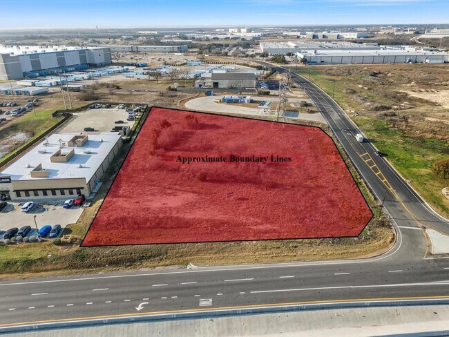
Property Record
1401 W Loop 340, Woodway, TX 76712
NEARBY LISTINGS FOR SALE OR LEASE
Property Detail
1401 W Loop 340
Waco, TX
Texas Central South
48-040706-000126-0
TEXAS CENTRAL SOUTH BLOCK 1 LOT 23 (N WACO ISD ACRES 1.636, SP MIDWAY ISD ACRES 4.069) TOTAL 5.705
Commercialnec
Mclennan
X
Texas
48309C0535D
23
2024
5.71 AC
2025
Waco & Killeen
002504
Other Market Areas
17,004 SF
DEMOGRAPHICS near 1401 W Loop 340
1 Mile
3 Mile
5 Mile
2024 Total Population
2,480
52,554
151,292
2029 Population
2,622
55,849
160,749
Pop Growth 2024-2029
+ 5.73%
+ 6.27%
+ 6.25%
Average Age
35
38
36
2024 Total Households
1,065
20,685
56,718
HH Growth 2024-2029
+ 5.92%
+ 6.43%
+ 6.58%
Median Household Inc
$61,466
$57,521
$56,581
Avg Household Size
2.30
2.40
2.50
2024 Avg HH Vehicles
2.00
2.00
2.00
Median Home Value
$211,454
$162,414
$187,102
Median Year Built
2010
1975
1978
Nearby Places
Map Layers
Map Styles
 Street
 Aerial
- Restaurants
- Banks
- Shops
- Fitness
- Groceries
PUBLIC TRANSPORTATION
AIRPORT
Waco Regional
DRIVE
WALK
Distance
Waco Regional
26 min
11.0 mi
Freight Ports
Port of Houston
DRIVE
WALK
Distance
Port of Houston
222 min
193.7 mi
SALE & LEASE HISTORY
LISTING DATE
SALE/LEASE

Mar 05, 2025
For Sale
Jul 12, 2018
For Sale
Nearby Properties
Address
Land Use
TOTAL SIZE
Lot Size
Zoning
Address
Land Use
TOTAL SIZE
Lot Size
Zoning
106.92 AC
Address
Land Use
TOTAL SIZE
Lot Size
Zoning
Address
Land Use
TOTAL SIZE
Lot Size
Zoning
462,987 SF
36.18 AC
C-3
Address
Land Use
TOTAL SIZE
Lot Size
Zoning
16,678 SF
19.91 AC
C3
Address
Land Use
TOTAL SIZE
Lot Size
Zoning
Address
Land Use
TOTAL SIZE
Lot Size
Zoning
405,640 SF
64.46 AC
Address
Land Use
TOTAL SIZE
Lot Size
Zoning
222,388 SF
10.68 AC
R-3C
Address
Land Use
TOTAL SIZE
Lot Size
Zoning
108,428 SF
9.27 AC
CS
Address
Land Use
TOTAL SIZE
Lot Size
Zoning
221,876 SF
12.26 AC
C-2
Address
Land Use
TOTAL SIZE
Lot Size
Zoning
211,432 SF
13.86 AC
O2
Address
Land Use
TOTAL SIZE
Lot Size
Zoning
Address
Land Use
TOTAL SIZE
Lot Size
Zoning
108,969 SF
24.73 AC
R-1
Address
Land Use
TOTAL SIZE
Lot Size
Zoning
181,423 SF
16.03 AC
R1B
Address
Land Use
TOTAL SIZE
Lot Size
Zoning
60,536 SF
0.93 AC
Address
Land Use
TOTAL SIZE
Lot Size
Zoning
223,307 SF
27.28 AC
O-2,
Address
Land Use
TOTAL SIZE
Lot Size
Zoning
146,635 SF
8.36 AC
R-3E
Address
Land Use
TOTAL SIZE
Lot Size
Zoning
80,890 SF
13.08 AC
O1
Address
Land Use
TOTAL SIZE
Lot Size
Zoning
69,600 SF
2 AC
Address
Land Use
TOTAL SIZE
Lot Size
Zoning
198,670 SF
10.24 AC
M1
Address
Land Use
TOTAL SIZE
Lot Size
Zoning
174,456 SF
9.04 AC
R3C
Address
Land Use
TOTAL SIZE
Lot Size
Zoning
10.26 AC
C2
Address
Land Use
TOTAL SIZE
Lot Size
Zoning
212,934 SF
21.91 AC
C3
Address
Land Use
TOTAL SIZE
Lot Size
Zoning
72,920 SF
11 AC
C-3
Address
Land Use
TOTAL SIZE
Lot Size
Zoning
Address
Land Use
TOTAL SIZE
Lot Size
Zoning
Address
Land Use
TOTAL SIZE
Lot Size
Zoning
86,014 SF
11.87 AC
R1
Address
Land Use
TOTAL SIZE
Lot Size
Zoning
94,262 SF
8.57 AC
CS
Address
Land Use
TOTAL SIZE
Lot Size
Zoning
203,384 SF
16.28 AC
C-2
Address
Land Use
TOTAL SIZE
Lot Size
Zoning
82.98 AC
M-2
Address
Land Use
TOTAL SIZE
Lot Size
Zoning
64,941 SF
5.38 AC
M-2
The World's #1 Commercial Real Estate Marketplace
Connect with us
© 2026 CoStar Group
The information above has been obtained from sources believed reliable. While we do not doubt its accuracy we have not verified it and make no guarantee, warranty or representation about it. It is your responsibility to independently confirm its accuracy and completeness. Any projections, opinions, assumptions, or estimates used are for example only and do not represent the current or future performance of the property. The value of this transaction to you depends on tax and other factors which should be evaluated by your tax, financial, and legal advisors. You and your advisors should conduct a careful, independent investigation of the property to determine to your satisfaction the suitability of the property for your needs.