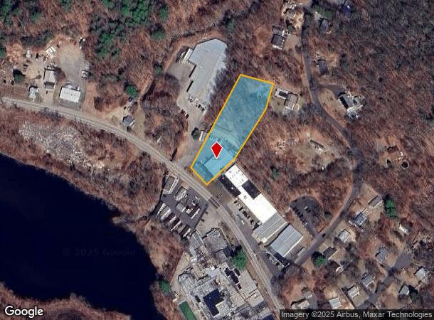
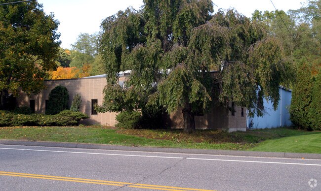
Property Record
1401 Waterbury Rd, Thomaston, CT 06787

NEARBY LISTINGS FOR SALE OR LEASE
Property Detail
1401 Waterbury Rd
Torrington, CT
Litchfield
THOM-000072-000004-000004
Connecticut
Industrialgeneral
4
2025
1.76 AC
2025
SE Litchfield County
349100
Hartford
DEMOGRAPHICS near 1401 Waterbury Rd
1 Mile
3 Mile
5 Mile
2024 Total Population
168
18,227
87,801
2029 Population
166
18,093
87,420
Pop Growth 2024-2029
(1.19%)
(0.74%)
(0.43%)
Average Age
44
42
40
2024 Total Households
78
7,480
33,871
HH Growth 2024-2029
(1.28%)
(0.75%)
(0.44%)
Median Household Inc
$93,749
$72,623
$69,324
Avg Household Size
2.10
2.40
2.50
2024 Avg HH Vehicles
2.00
2.00
2.00
Median Home Value
$203,571
$242,323
$227,916
Median Year Built
1983
1970
1965
Nearby Places
Map Layers
Map Styles
 Street
 Aerial
- Restaurants
- Banks
- Shops
- Fitness
- Groceries
PUBLIC TRANSPORTATION
COMMUTER RAIL
Waterbury Station (New Haven Line - Metro-North Commuter Railroad Company (Metro-North))
DRIVE
WALK
Distance
Waterbury Station (New Haven Line - Metro-North Commuter Railroad Company (Metro-North))
12 min
6.3 mi
AIRPORT
Tweed/New Haven
DRIVE
WALK
Distance
Tweed/New Haven
53 min
34.1 mi
Bradley International
DRIVE
WALK
Distance
Bradley International
70 min
41.0 mi
Freight Ports
Port of New Haven
DRIVE
WALK
Distance
Port of New Haven
48 min
31.2 mi
Nearby Properties
Address
Land Use
TOTAL SIZE
Lot Size
Zoning
Address
Land Use
TOTAL SIZE
Lot Size
Zoning
276,286 SF
19.50 AC
IG80
Address
Land Use
TOTAL SIZE
Lot Size
Zoning
306,366 SF
84 AC
RS-12
Address
Land Use
TOTAL SIZE
Lot Size
Zoning
201,817 SF
34.84 AC
R125
Address
Land Use
TOTAL SIZE
Lot Size
Zoning
140,700 SF
25.55 AC
R30
Address
Land Use
TOTAL SIZE
Lot Size
Zoning
65,974 SF
20.70 AC
RA15
Address
Land Use
TOTAL SIZE
Lot Size
Zoning
39 AC
RM
Address
Land Use
TOTAL SIZE
Lot Size
Zoning
30.46 AC
RM
Address
Land Use
TOTAL SIZE
Lot Size
Zoning
10 AC
RS-12
Address
Land Use
TOTAL SIZE
Lot Size
Zoning
24.60 AC
RM
Address
Land Use
TOTAL SIZE
Lot Size
Zoning
209.81 AC
R125
Address
Land Use
TOTAL SIZE
Lot Size
Zoning
326,357 SF
53.34 AC
IR200
Address
Land Use
TOTAL SIZE
Lot Size
Zoning
15 AC
M1
Address
Land Use
TOTAL SIZE
Lot Size
Zoning
60,703 SF
6.60 AC
R125
Address
Land Use
TOTAL SIZE
Lot Size
Zoning
216,200 SF
12.43 AC
IG
Address
Land Use
TOTAL SIZE
Lot Size
Zoning
178,860 SF
52.98 AC
IR200
Address
Land Use
TOTAL SIZE
Lot Size
Zoning
1,154 SF
435 AC
R90
Address
Land Use
TOTAL SIZE
Lot Size
Zoning
14.98 AC
IR200
Address
Land Use
TOTAL SIZE
Lot Size
Zoning
182,765 SF
9.08 AC
IG20F
Address
Land Use
TOTAL SIZE
Lot Size
Zoning
128,480 SF
19.91 AC
IR200
Address
Land Use
TOTAL SIZE
Lot Size
Zoning
132,377 SF
11.91 AC
IG20
Address
Land Use
TOTAL SIZE
Lot Size
Zoning
125,770 SF
19 AC
IR200
Address
Land Use
TOTAL SIZE
Lot Size
Zoning
96,721 SF
7.08 AC
IR200
Address
Land Use
TOTAL SIZE
Lot Size
Zoning
31.56 AC
IR8
Address
Land Use
TOTAL SIZE
Lot Size
Zoning
6.94 AC
R30
Address
Land Use
TOTAL SIZE
Lot Size
Zoning
65,041 SF
10 AC
IR8
Address
Land Use
TOTAL SIZE
Lot Size
Zoning
26,757 SF
5.29 AC
R125
Address
Land Use
TOTAL SIZE
Lot Size
Zoning
110,250 SF
31.74 AC
IR200
Address
Land Use
TOTAL SIZE
Lot Size
Zoning
89.72 AC
R125
Address
Land Use
TOTAL SIZE
Lot Size
Zoning
3.99 AC
RA1
Address
Land Use
TOTAL SIZE
Lot Size
Zoning
66,409 SF
13.59 AC
IR8
The World's #1 Commercial Real Estate Marketplace
Connect with us
© 2025 CoStar Group
The information above has been obtained from sources believed reliable. While we do not doubt its accuracy we have not verified it and make no guarantee, warranty or representation about it. It is your responsibility to independently confirm its accuracy and completeness. Any projections, opinions, assumptions, or estimates used are for example only and do not represent the current or future performance of the property. The value of this transaction to you depends on tax and other factors which should be evaluated by your tax, financial, and legal advisors. You and your advisors should conduct a careful, independent investigation of the property to determine to your satisfaction the suitability of the property for your needs.