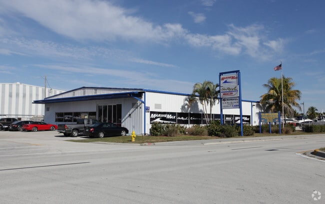
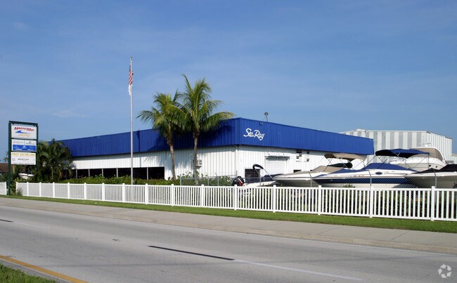
Property Record
14010 Mcgregor Blvd, Fort Myers, FL 33919

NEARBY LISTINGS FOR SALE OR LEASE
Property Detail
14010 Mcgregor Blvd
Cape Coral-Fort Myers, FL
Mcgregor / Summerlin
29-45-24-00-00011.002A
PARL LYING IN S 1/4 OF SEC 20 + N 1/4 OF SEC 29 + 2016000080042 LESS CONDO + LESS OR 3150/2405 + LESS 2016000080043
Transportnec
Lee
AE
Florida
12071C0416G
2a
2024
13.59 AC
2025
S Ft Myers/San Carlos
001802
Southwest Florida
118,605 SF
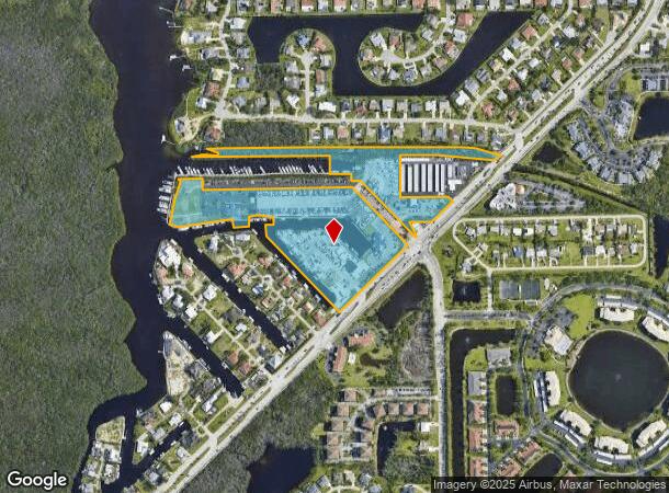
DEMOGRAPHICS near 14010 Mcgregor Blvd
1 Mile
3 Mile
5 Mile
2024 Total Population
8,438
66,084
156,180
2029 Population
10,053
78,879
185,452
Pop Growth 2024-2029
+ 19.14%
+ 19.36%
+ 18.74%
Average Age
57
53
51
2024 Total Households
4,339
33,095
74,723
HH Growth 2024-2029
+ 18.71%
+ 19.06%
+ 18.47%
Median Household Inc
$69,207
$61,051
$60,298
Avg Household Size
1.90
1.90
2.00
2024 Avg HH Vehicles
1.00
1.00
2.00
Median Home Value
$289,410
$277,010
$283,794
Median Year Built
1997
1990
1987
Nearby Places
Map Layers
Map Styles
 Street
 Aerial
- Restaurants
- Banks
- Shops
- Fitness
- Groceries
PUBLIC TRANSPORTATION
AIRPORT
Southwest Florida International
DRIVE
WALK
Distance
Southwest Florida International
23 min
11.8 mi
Punta Gorda
DRIVE
WALK
Distance
Punta Gorda
51 min
31.4 mi
Nearby Properties
Address
Land Use
TOTAL SIZE
Lot Size
Zoning
Address
Land Use
TOTAL SIZE
Lot Size
Zoning
1,116,051 SF
35.44 AC
CPD
Address
Land Use
TOTAL SIZE
Lot Size
Zoning
1,001,577 SF
140.54 AC
AG-2
Address
Land Use
TOTAL SIZE
Lot Size
Zoning
Address
Land Use
TOTAL SIZE
Lot Size
Zoning
539,207 SF
61.09 AC
AG-2
Address
Land Use
TOTAL SIZE
Lot Size
Zoning
562,104 SF
18.98 AC
RPD
Address
Land Use
TOTAL SIZE
Lot Size
Zoning
446,205 SF
28.90 AC
CC
Address
Land Use
TOTAL SIZE
Lot Size
Zoning
564,663 SF
33.53 AC
CPD
Address
Land Use
TOTAL SIZE
Lot Size
Zoning
334,148 SF
48.67 AC
RM-2
Address
Land Use
TOTAL SIZE
Lot Size
Zoning
423,044 SF
37.11 AC
C-1
Address
Land Use
TOTAL SIZE
Lot Size
Zoning
441,655 SF
33.09 AC
RM-2
Address
Land Use
TOTAL SIZE
Lot Size
Zoning
335,660 SF
15.42 AC
MPD
Address
Land Use
TOTAL SIZE
Lot Size
Zoning
209,483 SF
15.03 AC
CF-2
Address
Land Use
TOTAL SIZE
Lot Size
Zoning
381,135 SF
15.07 AC
MPD
Address
Land Use
TOTAL SIZE
Lot Size
Zoning
1,446 SF
9.81 AC
RS-6
Address
Land Use
TOTAL SIZE
Lot Size
Zoning
261,136 SF
11.68 AC
AG-2
Address
Land Use
TOTAL SIZE
Lot Size
Zoning
9,670 SF
9.12 AC
AG-2
Address
Land Use
TOTAL SIZE
Lot Size
Zoning
206,290 SF
31.37 AC
CFPD
Address
Land Use
TOTAL SIZE
Lot Size
Zoning
153,907 SF
22.03 AC
TFC2
Address
Land Use
TOTAL SIZE
Lot Size
Zoning
96,448 SF
3.85 AC
CPD
Address
Land Use
TOTAL SIZE
Lot Size
Zoning
211,588 SF
14.89 AC
MPD
Address
Land Use
TOTAL SIZE
Lot Size
Zoning
74,747 SF
2.76 AC
CPD
Address
Land Use
TOTAL SIZE
Lot Size
Zoning
469,746 SF
89.45 AC
RPD
Address
Land Use
TOTAL SIZE
Lot Size
Zoning
66,486 SF
0.56 AC
C-1A
Address
Land Use
TOTAL SIZE
Lot Size
Zoning
65,051 SF
4.89 AC
CFPD
Address
Land Use
TOTAL SIZE
Lot Size
Zoning
301,212 SF
5.28 AC
Address
Land Use
TOTAL SIZE
Lot Size
Zoning
84,147 SF
10.60 AC
CPD
Address
Land Use
TOTAL SIZE
Lot Size
Zoning
89,321 SF
11.40 AC
CPD
Address
Land Use
TOTAL SIZE
Lot Size
Zoning
85,745 SF
10.22 AC
CPD
Address
Land Use
TOTAL SIZE
Lot Size
Zoning
346,481 SF
11.41 AC
CPD
Address
Land Use
TOTAL SIZE
Lot Size
Zoning
13.65 AC
CPD
The World's #1 Commercial Real Estate Marketplace
Connect with us
© 2025 CoStar Group
The information above has been obtained from sources believed reliable. While we do not doubt its accuracy we have not verified it and make no guarantee, warranty or representation about it. It is your responsibility to independently confirm its accuracy and completeness. Any projections, opinions, assumptions, or estimates used are for example only and do not represent the current or future performance of the property. The value of this transaction to you depends on tax and other factors which should be evaluated by your tax, financial, and legal advisors. You and your advisors should conduct a careful, independent investigation of the property to determine to your satisfaction the suitability of the property for your needs.