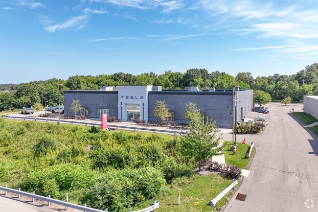
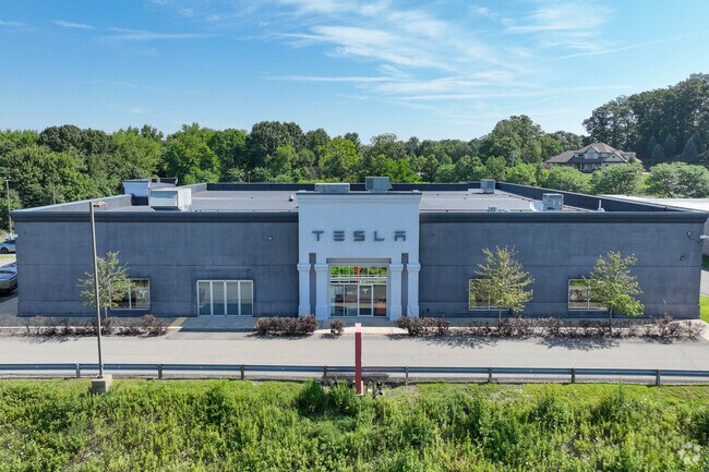
Property Record
14010 Perry Hwy, Wexford, PA 15090
NEARBY LISTINGS FOR SALE OR LEASE
Property Detail
14010 Perry Hwy
Pittsburgh, PA
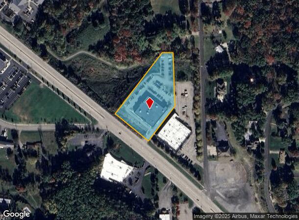
Second Revision To The Tep Plan
1824-C-00015-0000-00
SECOND REVISION TO THE TEP PLAN 102 IRREG LOT = 261.91X468.53X67.15 OR 108,014 SF (2.48 ALD) PERRY HIGHWAY S.R. 19
Vehiclerentalsvehiclesales
Allegheny
X
Pennsylvania
42019C0514D
15
2024
2.48 AC
2025
North Pittsburgh/Rte 19
411002
Pittsburgh
DEMOGRAPHICS near 14010 Perry Hwy
1 Mile
3 Mile
5 Mile
2024 Total Population
3,771
29,745
81,156
2029 Population
3,719
29,473
80,792
Pop Growth 2024-2029
(1.38%)
(0.91%)
(0.45%)
Average Age
40
40
41
2024 Total Households
1,378
11,004
30,489
HH Growth 2024-2029
(1.52%)
(0.75%)
(0.33%)
Median Household Inc
$145,378
$150,461
$130,644
Avg Household Size
2.60
2.60
2.60
2024 Avg HH Vehicles
2.00
2.00
2.00
Median Home Value
$433,668
$422,227
$392,611
Median Year Built
1998
1997
1992
Nearby Places
Map Layers
Map Styles
 Street
 Aerial
- Restaurants
- Banks
- Shops
- Fitness
- Groceries
PUBLIC TRANSPORTATION
AIRPORT
Pittsburgh International
DRIVE
WALK
Distance
Pittsburgh International
37 min
19.4 mi
SALE & LEASE HISTORY
LISTING DATE
SALE/LEASE

Oct 13, 2017
For Sale
Oct 11, 2017
For Sale
Nov 22, 2023
For Sale
Mar 30, 2018
For Sale
Mar 17, 2017
For Sale
Mar 17, 2017
For Sale
Jan 23, 2017
For Sale
Feb 13, 2017
For Sale
Dec 03, 2024
For Sale
Apr 21, 2017
For Sale
Nearby Properties
Address
Land Use
TOTAL SIZE
Lot Size
Zoning
Address
Land Use
TOTAL SIZE
Lot Size
Zoning
1.82 AC
Address
Land Use
TOTAL SIZE
Lot Size
Zoning
80.58 AC
Address
Land Use
TOTAL SIZE
Lot Size
Zoning
30.03 AC
Address
Land Use
TOTAL SIZE
Lot Size
Zoning
48.35 AC
Address
Land Use
TOTAL SIZE
Lot Size
Zoning
101.14 AC
Address
Land Use
TOTAL SIZE
Lot Size
Zoning
2.58 AC
Address
Land Use
TOTAL SIZE
Lot Size
Zoning
18.78 AC
Address
Land Use
TOTAL SIZE
Lot Size
Zoning
23.48 AC
Address
Land Use
TOTAL SIZE
Lot Size
Zoning
10.62 AC
Address
Land Use
TOTAL SIZE
Lot Size
Zoning
1,421 SF
24.62 AC
Address
Land Use
TOTAL SIZE
Lot Size
Zoning
16.90 AC
Address
Land Use
TOTAL SIZE
Lot Size
Zoning
7.80 AC
Address
Land Use
TOTAL SIZE
Lot Size
Zoning
12.73 AC
Address
Land Use
TOTAL SIZE
Lot Size
Zoning
Address
Land Use
TOTAL SIZE
Lot Size
Zoning
14.80 AC
Address
Land Use
TOTAL SIZE
Lot Size
Zoning
Address
Land Use
TOTAL SIZE
Lot Size
Zoning
7.21 AC
Address
Land Use
TOTAL SIZE
Lot Size
Zoning
10.62 AC
Address
Land Use
TOTAL SIZE
Lot Size
Zoning
9.20 AC
Address
Land Use
TOTAL SIZE
Lot Size
Zoning
39.82 AC
Address
Land Use
TOTAL SIZE
Lot Size
Zoning
12.44 AC
Address
Land Use
TOTAL SIZE
Lot Size
Zoning
Address
Land Use
TOTAL SIZE
Lot Size
Zoning
9.04 AC
Address
Land Use
TOTAL SIZE
Lot Size
Zoning
7.58 AC
Address
Land Use
TOTAL SIZE
Lot Size
Zoning
1.59 AC
Address
Land Use
TOTAL SIZE
Lot Size
Zoning
11.95 AC
Address
Land Use
TOTAL SIZE
Lot Size
Zoning
20.84 AC
Address
Land Use
TOTAL SIZE
Lot Size
Zoning
13.59 AC
Address
Land Use
TOTAL SIZE
Lot Size
Zoning
2.35 AC
Address
Land Use
TOTAL SIZE
Lot Size
Zoning
814 SF
10.79 AC
The World's #1 Commercial Real Estate Marketplace
Connect with us
© 2026 CoStar Group
The information above has been obtained from sources believed reliable. While we do not doubt its accuracy we have not verified it and make no guarantee, warranty or representation about it. It is your responsibility to independently confirm its accuracy and completeness. Any projections, opinions, assumptions, or estimates used are for example only and do not represent the current or future performance of the property. The value of this transaction to you depends on tax and other factors which should be evaluated by your tax, financial, and legal advisors. You and your advisors should conduct a careful, independent investigation of the property to determine to your satisfaction the suitability of the property for your needs.