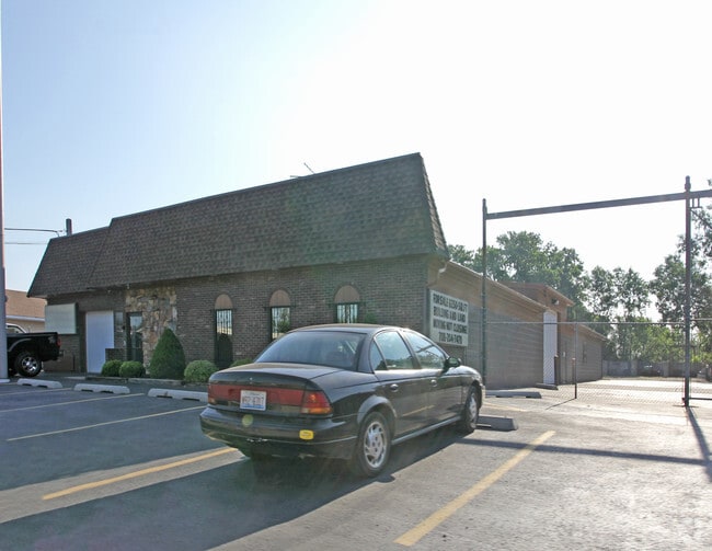
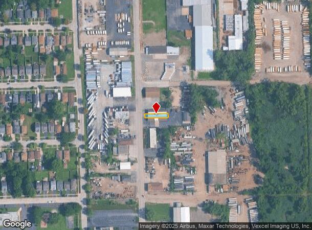
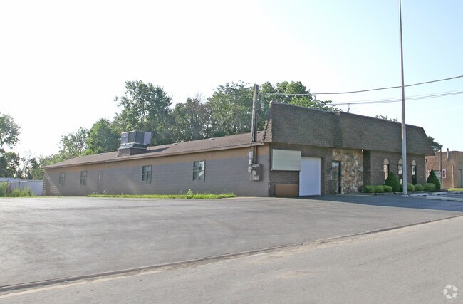
Property Record
14013 S Harrison Ave, Posen, IL 60469
NEARBY LISTINGS FOR SALE OR LEASE
Property Detail
14013 S Harrison Ave
Chicago-Naperville-Elgin, IL-IN-WI
Bass Add
28-01-405-004-0000
(BASS) ADD SUB OF LT 3 IN FORSYTHES SUB IN WH SE SEC 01-36-13
Taxexempt
Cook
X
Illinois
17031C0643J
3
0
0.76 AC
2024
Near South Cook
824800
Chicago
DEMOGRAPHICS near 14013 S Harrison Ave
1 Mile
3 Mile
5 Mile
2024 Total Population
12,828
108,213
313,583
2029 Population
12,748
107,191
308,162
Pop Growth 2024-2029
(0.62%)
(0.94%)
(1.73%)
Average Age
38
40
40
2024 Total Households
4,278
39,782
116,290
HH Growth 2024-2029
(0.61%)
(1.23%)
(2.00%)
Median Household Inc
$50,193
$48,325
$57,657
Avg Household Size
2.90
2.60
2.60
2024 Avg HH Vehicles
2.00
2.00
2.00
Median Home Value
$133,962
$144,492
$173,944
Median Year Built
1967
1964
1962
Nearby Places
Map Layers
Map Styles
 Street
 Aerial
- Restaurants
- Banks
- Shops
- Fitness
- Groceries
PUBLIC TRANSPORTATION
COMMUTER RAIL
Robbins Station (Rock Island District Line - Northeast Illinois Regional Commuter Railroad (Metra))
DRIVE
WALK
Distance
Robbins Station (Rock Island District Line - Northeast Illinois Regional Commuter Railroad (Metra))
2 min
9 min
0.5 mi
Blue Island - Vermont Street Station (Metra Electric Line - Northeast Illinois Regional Commuter Railroad (Metra), Rock Island District Line - Northeast Illinois Regional Commuter Railroad (Metra))
DRIVE
WALK
Distance
Blue Island - Vermont Street Station (Metra Electric Line - Northeast Illinois Regional Commuter Railroad (Metra), Rock Island District Line - Northeast Illinois Regional Commuter Railroad (Metra))
5 min
1.9 mi
AIRPORT
Chicago Midway International
DRIVE
WALK
Distance
Chicago Midway International
25 min
14.5 mi
Chicago O'Hare International
DRIVE
WALK
Distance
Chicago O'Hare International
50 min
36.2 mi
Freight Ports
Port Milwaukee
DRIVE
WALK
Distance
Port Milwaukee
131 min
108.0 mi
Nearby Properties
Address
Land Use
TOTAL SIZE
Lot Size
Zoning
Address
Land Use
TOTAL SIZE
Lot Size
Zoning
Address
Land Use
TOTAL SIZE
Lot Size
Zoning
83,005 SF
3.11 AC
Address
Land Use
TOTAL SIZE
Lot Size
Zoning
380,924 SF
19.13 AC
Address
Land Use
TOTAL SIZE
Lot Size
Zoning
421,052 SF
26.15 AC
Address
Land Use
TOTAL SIZE
Lot Size
Zoning
152,306 SF
13.40 AC
Address
Land Use
TOTAL SIZE
Lot Size
Zoning
185,748 SF
15.30 AC
Address
Land Use
TOTAL SIZE
Lot Size
Zoning
405,045 SF
14.49 AC
Address
Land Use
TOTAL SIZE
Lot Size
Zoning
Address
Land Use
TOTAL SIZE
Lot Size
Zoning
Address
Land Use
TOTAL SIZE
Lot Size
Zoning
162,379 SF
10.59 AC
Address
Land Use
TOTAL SIZE
Lot Size
Zoning
Address
Land Use
TOTAL SIZE
Lot Size
Zoning
8,800 SF
8.83 AC
Address
Land Use
TOTAL SIZE
Lot Size
Zoning
9.38 AC
Address
Land Use
TOTAL SIZE
Lot Size
Zoning
451,400 SF
26.59 AC
M3-3
Address
Land Use
TOTAL SIZE
Lot Size
Zoning
1.91 AC
Address
Land Use
TOTAL SIZE
Lot Size
Zoning
121,968 SF
13.31 AC
Address
Land Use
TOTAL SIZE
Lot Size
Zoning
49,229 SF
1.31 AC
Address
Land Use
TOTAL SIZE
Lot Size
Zoning
0.98 AC
Address
Land Use
TOTAL SIZE
Lot Size
Zoning
132,322 SF
2 AC
Address
Land Use
TOTAL SIZE
Lot Size
Zoning
63,255 SF
6.03 AC
Address
Land Use
TOTAL SIZE
Lot Size
Zoning
186,880 SF
15 AC
Address
Land Use
TOTAL SIZE
Lot Size
Zoning
Address
Land Use
TOTAL SIZE
Lot Size
Zoning
80,161 SF
2.09 AC
Address
Land Use
TOTAL SIZE
Lot Size
Zoning
370,258 SF
5.12 AC
Address
Land Use
TOTAL SIZE
Lot Size
Zoning
13,327 SF
64.93 AC
Address
Land Use
TOTAL SIZE
Lot Size
Zoning
90,890 SF
2.35 AC
Address
Land Use
TOTAL SIZE
Lot Size
Zoning
513,843 SF
23.76 AC
Address
Land Use
TOTAL SIZE
Lot Size
Zoning
20,579 SF
1.14 AC
Address
Land Use
TOTAL SIZE
Lot Size
Zoning
59,497 SF
5.10 AC
The World's #1 Commercial Real Estate Marketplace
Connect with us
© 2025 CoStar Group
The information above has been obtained from sources believed reliable. While we do not doubt its accuracy we have not verified it and make no guarantee, warranty or representation about it. It is your responsibility to independently confirm its accuracy and completeness. Any projections, opinions, assumptions, or estimates used are for example only and do not represent the current or future performance of the property. The value of this transaction to you depends on tax and other factors which should be evaluated by your tax, financial, and legal advisors. You and your advisors should conduct a careful, independent investigation of the property to determine to your satisfaction the suitability of the property for your needs.