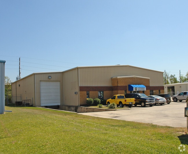
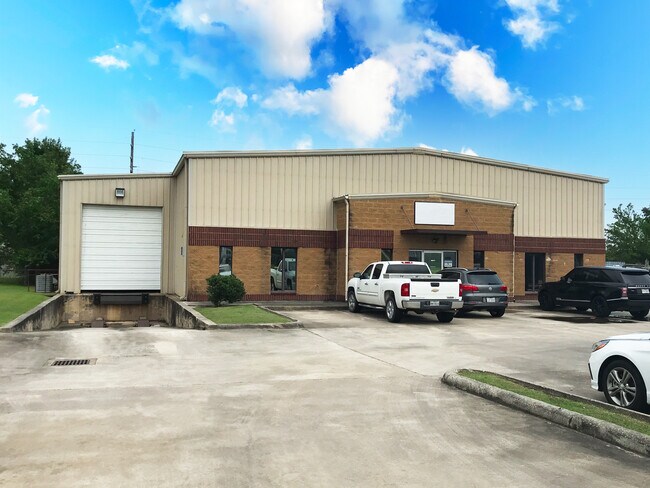
Property Record
14014 Interdrive E, Houston, TX 77032

NEARBY LISTINGS FOR SALE OR LEASE
Property Detail
14014 Interdrive E
1162020000040
Interbeltnorth Business Ctr
Warehouse
RES E1 INTERBELT NORTH BUSINESS CTR
AE
Harris
48201C0490L
Texas
2024
0.64 AC
2025
North Outer Loop
223100
Houston
10,102 SF
Houston-The Woodlands-Sugar Land, TX
DEMOGRAPHICS near 14014 Interdrive E
1 Mile
3 Mile
5 Mile
2024 Total Population
3,501
57,628
191,553
2029 Population
3,512
58,541
194,382
Pop Growth 2024-2029
+ 0.31%
+ 1.58%
+ 1.48%
Average Age
35
33
34
2024 Total Households
946
16,541
57,917
HH Growth 2024-2029
+ 0.21%
+ 1.56%
+ 1.49%
Median Household Inc
$39,963
$37,064
$38,901
Avg Household Size
3.50
3.30
3.20
2024 Avg HH Vehicles
2.00
2.00
2.00
Median Home Value
$162,112
$124,631
$138,231
Median Year Built
1982
1976
1976
Nearby Places
Map Layers
Map Styles
 Street
 Aerial
- Restaurants
- Banks
- Shops
- Fitness
- Groceries
PUBLIC TRANSPORTATION
AIRPORT
George Bush Intcntl/Houston
DRIVE
WALK
Distance
George Bush Intcntl/Houston
8 min
4.8 mi
William P Hobby
DRIVE
WALK
Distance
William P Hobby
44 min
27.7 mi
Freight Ports
Port of Houston
DRIVE
WALK
Distance
Port of Houston
33 min
21.3 mi
SALE & LEASE HISTORY
LISTING DATE
SALE/LEASE

Sep 21, 2021
For Sale
Jun 23, 2021
For Lease
Jul 10, 2020
For Lease
Jul 10, 2020
For Sale
Jan 30, 2019
For Sale
Feb 19, 2019
For Sale
Nearby Properties
Address
Land Use
TOTAL SIZE
Lot Size
Zoning
Address
Land Use
TOTAL SIZE
Lot Size
Zoning
1,213,044 SF
69.99 AC
Address
Land Use
TOTAL SIZE
Lot Size
Zoning
1,767,053 SF
88.85 AC
Address
Land Use
TOTAL SIZE
Lot Size
Zoning
785,390 SF
66.02 AC
Address
Land Use
TOTAL SIZE
Lot Size
Zoning
621,700 SF
67.57 AC
Address
Land Use
TOTAL SIZE
Lot Size
Zoning
704,105 SF
40.72 AC
Address
Land Use
TOTAL SIZE
Lot Size
Zoning
500,000 SF
24.58 AC
Address
Land Use
TOTAL SIZE
Lot Size
Zoning
523,480 SF
29.22 AC
Address
Land Use
TOTAL SIZE
Lot Size
Zoning
379,570 SF
30.12 AC
Address
Land Use
TOTAL SIZE
Lot Size
Zoning
431,400 SF
30.88 AC
Address
Land Use
TOTAL SIZE
Lot Size
Zoning
368,632 SF
20.06 AC
Address
Land Use
TOTAL SIZE
Lot Size
Zoning
338,700 SF
22.99 AC
Address
Land Use
TOTAL SIZE
Lot Size
Zoning
241,625 SF
11.10 AC
Address
Land Use
TOTAL SIZE
Lot Size
Zoning
353,600 SF
23.45 AC
Address
Land Use
TOTAL SIZE
Lot Size
Zoning
361,919 SF
23.59 AC
Address
Land Use
TOTAL SIZE
Lot Size
Zoning
448,760 SF
8.46 AC
Address
Land Use
TOTAL SIZE
Lot Size
Zoning
207,720 SF
12.33 AC
Address
Land Use
TOTAL SIZE
Lot Size
Zoning
227,400 SF
19.37 AC
Address
Land Use
TOTAL SIZE
Lot Size
Zoning
264,300 SF
15.89 AC
Address
Land Use
TOTAL SIZE
Lot Size
Zoning
170,407 SF
26.31 AC
Address
Land Use
TOTAL SIZE
Lot Size
Zoning
281,252 SF
8 AC
Address
Land Use
TOTAL SIZE
Lot Size
Zoning
215,879 SF
7.30 AC
Address
Land Use
TOTAL SIZE
Lot Size
Zoning
90,033 SF
46.96 AC
Address
Land Use
TOTAL SIZE
Lot Size
Zoning
109,025 SF
6 AC
Address
Land Use
TOTAL SIZE
Lot Size
Zoning
181,200 SF
11.07 AC
Address
Land Use
TOTAL SIZE
Lot Size
Zoning
181,830 SF
15.12 AC
Address
Land Use
TOTAL SIZE
Lot Size
Zoning
314,294 SF
29.50 AC
Address
Land Use
TOTAL SIZE
Lot Size
Zoning
181,720 SF
15.28 AC
Address
Land Use
TOTAL SIZE
Lot Size
Zoning
236,780 SF
35.30 AC
Address
Land Use
TOTAL SIZE
Lot Size
Zoning
159,840 SF
16.13 AC
Address
Land Use
TOTAL SIZE
Lot Size
Zoning
738,939 SF
88.85 AC
The World's #1 Commercial Real Estate Marketplace
Connect with us
© 2025 CoStar Group
The information above has been obtained from sources believed reliable. While we do not doubt its accuracy we have not verified it and make no guarantee, warranty or representation about it. It is your responsibility to independently confirm its accuracy and completeness. Any projections, opinions, assumptions, or estimates used are for example only and do not represent the current or future performance of the property. The value of this transaction to you depends on tax and other factors which should be evaluated by your tax, financial, and legal advisors. You and your advisors should conduct a careful, independent investigation of the property to determine to your satisfaction the suitability of the property for your needs.