Property Record
1402 E Borgfeld Dr, San Antonio, TX 78260
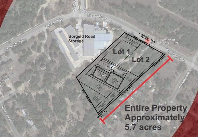


Property Detail
1402 E Borgfeld Dr
San Antonio-New Braunfels, TX
CB 4852 P-3B ABS 263 2022- RSVY PER DEED 20210248835 EXE 9-1-2021. ASGIS04-21-2022.
04852-000-0032
BEXAR
Miscellaneous
Texas
B and X Area of moderate flood hazard, usually the area between the limits of the 100-year and 500-year floods.
3b
2024
5.73 AC
2025
Far North Central
191814
San Antonio
1,568 SF
NEARBY LISTINGS FOR SALE OR LEASE
DEMOGRAPHICS near 1402 E Borgfeld Dr
1 mile
3 mile
5 mile
2025 Total Population
4,966
34,690
90,168
2030 Population
5,384
37,504
97,098
Pop Growth 2025-2030
+ 8.42%
+ 8.11%
+ 7.69%
Average Age
38
39
38
2025 Total Households
1,599
11,724
30,086
HH Growth 2025-2030
+ 8.51%
+ 8.26%
+ 7.95%
Median Household Inc
$134,399
$137,003
$135,963
Avg Household Size
3.10
2.90
3.00
2025 Avg HH Vehicles
2.00
2.00
2.00
Median Home Value
$463,235
$467,467
$474,270
Median Year Built
2010
2008
2008
Nearby Places
Map Layers
Map Styles
 Street
 Aerial
Transit
 Traffic
 Biking
Places
Listings with unknown addresses are not visible on the map
- Restaurants
- Banks
- Shops
- Fitness
- Groceries
PUBLIC TRANSPORTATION
AIRPORT
San Antonio International
Drive
Walk
Distance
San Antonio International
19 min
15.4 mi
Freight Ports
Calhoun Port
Drive
Walk
Distance
Calhoun Port
197 min
164.2 mi
SALE & LEASE HISTORY
LISTING DATE
SALE/LEASE

Sep 13, 2022
For Sale
Jul 27, 2022
For Sale
Feb 11, 2022
For Sale
Aug 28, 2024
For Sale
Aug 13, 2018
For Sale
Apr 13, 2022
For Sale
Nearby Properties
Address
Land Use
TOTAL SIZE
Lot Size
Zoning
Address
Land Use
TOTAL SIZE
Lot Size
Zoning
310,384 SF
14.25 AC
Address
Land Use
TOTAL SIZE
Lot Size
Zoning
123,938 SF
27.21 AC
Address
Land Use
TOTAL SIZE
Lot Size
Zoning
296,413 SF
15 AC
Address
Land Use
TOTAL SIZE
Lot Size
Zoning
137,704 SF
26.31 AC
Address
Land Use
TOTAL SIZE
Lot Size
Zoning
35,888 SF
6.06 AC
Address
Land Use
TOTAL SIZE
Lot Size
Zoning
66,166 SF
85.74 AC
Address
Land Use
TOTAL SIZE
Lot Size
Zoning
54,150 SF
3.47 AC
Address
Land Use
TOTAL SIZE
Lot Size
Zoning
28.60 AC
Address
Land Use
TOTAL SIZE
Lot Size
Zoning
25.20 AC
Address
Land Use
TOTAL SIZE
Lot Size
Zoning
Address
Land Use
TOTAL SIZE
Lot Size
Zoning
22.75 AC
Address
Land Use
TOTAL SIZE
Lot Size
Zoning
20.13 AC
Address
Land Use
TOTAL SIZE
Lot Size
Zoning
19,952 SF
3.32 AC
Address
Land Use
TOTAL SIZE
Lot Size
Zoning
74,320 SF
4.55 AC
Address
Land Use
TOTAL SIZE
Lot Size
Zoning
76,120 SF
3.90 AC
Address
Land Use
TOTAL SIZE
Lot Size
Zoning
20.95 AC
Address
Land Use
TOTAL SIZE
Lot Size
Zoning
Address
Land Use
TOTAL SIZE
Lot Size
Zoning
183.24 AC
Address
Land Use
TOTAL SIZE
Lot Size
Zoning
19.32 AC
Address
Land Use
TOTAL SIZE
Lot Size
Zoning
5,400 SF
3.24 AC
Address
Land Use
TOTAL SIZE
Lot Size
Zoning
8,740 SF
6.36 AC
Address
Land Use
TOTAL SIZE
Lot Size
Zoning
17,000 SF
1.77 AC
Address
Land Use
TOTAL SIZE
Lot Size
Zoning
134.81 AC
Address
Land Use
TOTAL SIZE
Lot Size
Zoning
71,743 SF
6.87 AC
Address
Land Use
TOTAL SIZE
Lot Size
Zoning
6,590 SF
211.63 AC
Address
Land Use
TOTAL SIZE
Lot Size
Zoning
9,280 SF
3.93 AC
Address
Land Use
TOTAL SIZE
Lot Size
Zoning
2,021 SF
18.28 AC
Address
Land Use
TOTAL SIZE
Lot Size
Zoning
15,966 SF
1.72 AC
Address
Land Use
TOTAL SIZE
Lot Size
Zoning
1,070 SF
303.68 AC
Address
Land Use
TOTAL SIZE
Lot Size
Zoning
23.12 AC
The World's #1 Commercial Real Estate Marketplace
Connect with us
© 2026 CoStar Group
The information above has been obtained from sources believed reliable. While we do not doubt its accuracy we have not verified it and make no guarantee, warranty or representation about it. It is your responsibility to independently confirm its accuracy and completeness. Any projections, opinions, assumptions, or estimates used are for example only and do not represent the current or future performance of the property. The value of this transaction to you depends on tax and other factors which should be evaluated by your tax, financial, and legal advisors. You and your advisors should conduct a careful, independent investigation of the property to determine to your satisfaction the suitability of the property for your needs.