Property Record
1402 Mays Landing Rd, Hammonton, NJ 08037
NEARBY LISTINGS FOR SALE OR LEASE
-
-
View all Hammonton listings for sale on LoopNet.com
Property Detail
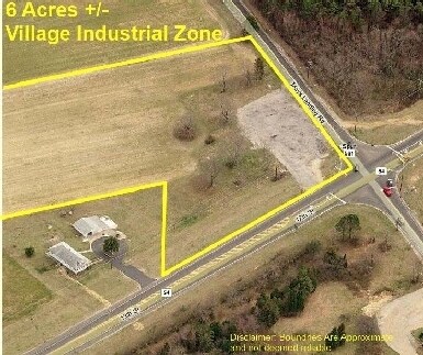
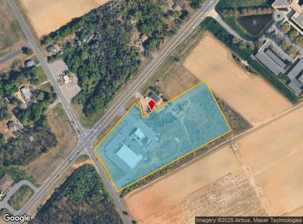
1402 Mays Landing Rd
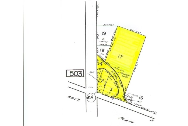
10-00502-0000-00017-01
State Highway Development
Storebuilding
Atlantic
X
New Jersey
34001C0102F
17.1
2024
6.37 AC
2025
Atlantic City/Hammonton
011201
Philadelphia
10,746 SF
Atlantic City-Hammonton, NJ
DEMOGRAPHICS near 1402 Mays Landing Rd
1 Mile
3 Mile
5 Mile
2024 Total Population
341
7,396
19,633
2029 Population
330
7,217
19,178
Pop Growth 2024-2029
(3.23%)
(2.42%)
(2.32%)
Average Age
42
40
41
2024 Total Households
116
2,585
7,124
HH Growth 2024-2029
(3.45%)
(3.06%)
(2.91%)
Median Household Inc
$107,954
$81,767
$75,605
Avg Household Size
2.80
2.70
2.60
2024 Avg HH Vehicles
2.00
2.00
2.00
Median Home Value
$243,750
$227,015
$245,773
Median Year Built
1972
1965
1969
Nearby Places
Map Layers
Map Styles
 Street
 Aerial
- Restaurants
- Banks
- Shops
- Fitness
- Groceries
PUBLIC TRANSPORTATION
COMMUTER RAIL
Hammonton (Atlantic City Line - NJ Transit Commuter Rail (NJ Transit))
DRIVE
WALK
Distance
Hammonton (Atlantic City Line - NJ Transit Commuter Rail (NJ Transit))
5 min
3.4 mi
AIRPORT
Atlantic City International
DRIVE
WALK
Distance
Atlantic City International
47 min
23.0 mi
Philadelphia International
DRIVE
WALK
Distance
Philadelphia International
53 min
37.8 mi
Freight Ports
Broadway Terminal - Pier 5
DRIVE
WALK
Distance
Broadway Terminal - Pier 5
38 min
29.3 mi
Nearby Properties
Address
Land Use
TOTAL SIZE
Lot Size
Zoning
Address
Land Use
TOTAL SIZE
Lot Size
Zoning
55.80 AC
Address
Land Use
TOTAL SIZE
Lot Size
Zoning
35.12 AC
Address
Land Use
TOTAL SIZE
Lot Size
Zoning
106.44 AC
2011
Address
Land Use
TOTAL SIZE
Lot Size
Zoning
10.91 AC
Address
Land Use
TOTAL SIZE
Lot Size
Zoning
25.03 AC
VR
Address
Land Use
TOTAL SIZE
Lot Size
Zoning
1,336 SF
12.36 AC
Address
Land Use
TOTAL SIZE
Lot Size
Zoning
19.63 AC
RDR1
Address
Land Use
TOTAL SIZE
Lot Size
Zoning
19.51 AC
RD
Address
Land Use
TOTAL SIZE
Lot Size
Zoning
2,046 SF
7.12 AC
Address
Land Use
TOTAL SIZE
Lot Size
Zoning
Address
Land Use
TOTAL SIZE
Lot Size
Zoning
16,731 SF
0.71 AC
Address
Land Use
TOTAL SIZE
Lot Size
Zoning
22.07 AC
Address
Land Use
TOTAL SIZE
Lot Size
Zoning
162.42 AC
PR1
Address
Land Use
TOTAL SIZE
Lot Size
Zoning
50,225 SF
6.46 AC
AP
Address
Land Use
TOTAL SIZE
Lot Size
Zoning
31.77 AC
VR
Address
Land Use
TOTAL SIZE
Lot Size
Zoning
13,024 SF
22.83 AC
AP
Address
Land Use
TOTAL SIZE
Lot Size
Zoning
20,102 SF
3.84 AC
Address
Land Use
TOTAL SIZE
Lot Size
Zoning
12.17 AC
PI3
Address
Land Use
TOTAL SIZE
Lot Size
Zoning
19.64 AC
Address
Land Use
TOTAL SIZE
Lot Size
Zoning
72,124 SF
2.24 AC
Address
Land Use
TOTAL SIZE
Lot Size
Zoning
7.40 AC
AG
Address
Land Use
TOTAL SIZE
Lot Size
Zoning
7.15 AC
RD
Address
Land Use
TOTAL SIZE
Lot Size
Zoning
14.71 AC
VR
Address
Land Use
TOTAL SIZE
Lot Size
Zoning
1 AC
AP
Address
Land Use
TOTAL SIZE
Lot Size
Zoning
12.65 AC
Address
Land Use
TOTAL SIZE
Lot Size
Zoning
14.02 AC
VR
Address
Land Use
TOTAL SIZE
Lot Size
Zoning
3.07 AC
Address
Land Use
TOTAL SIZE
Lot Size
Zoning
Address
Land Use
TOTAL SIZE
Lot Size
Zoning
7,720 SF
1.41 AC
The World's #1 Commercial Real Estate Marketplace
Connect with us
© 2026 CoStar Group
The information above has been obtained from sources believed reliable. While we do not doubt its accuracy we have not verified it and make no guarantee, warranty or representation about it. It is your responsibility to independently confirm its accuracy and completeness. Any projections, opinions, assumptions, or estimates used are for example only and do not represent the current or future performance of the property. The value of this transaction to you depends on tax and other factors which should be evaluated by your tax, financial, and legal advisors. You and your advisors should conduct a careful, independent investigation of the property to determine to your satisfaction the suitability of the property for your needs.