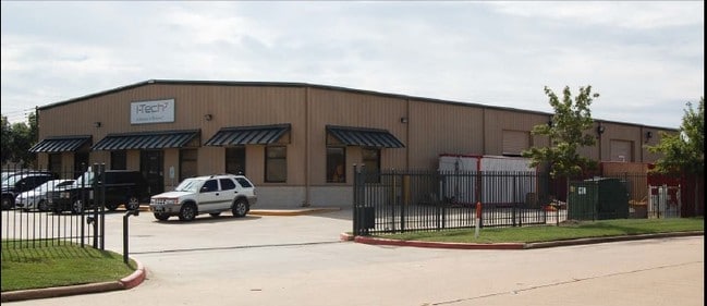
Property Record
1402 Vanderwilt Ln, Katy, TX 77449
NEARBY LISTINGS FOR SALE OR LEASE
Property Detail
1402 Vanderwilt Ln
1261250010001
Westgreen Business Center
Warehouse
RES A BLK 1 WESTGREEN BUSINESS CENTER
X
Harris
48201C0615M
Texas
2024
6.59 AC
2025
Northwest Outliers
542402
Houston
88,500 SF
Houston-Pasadena-The Woodlands, TX
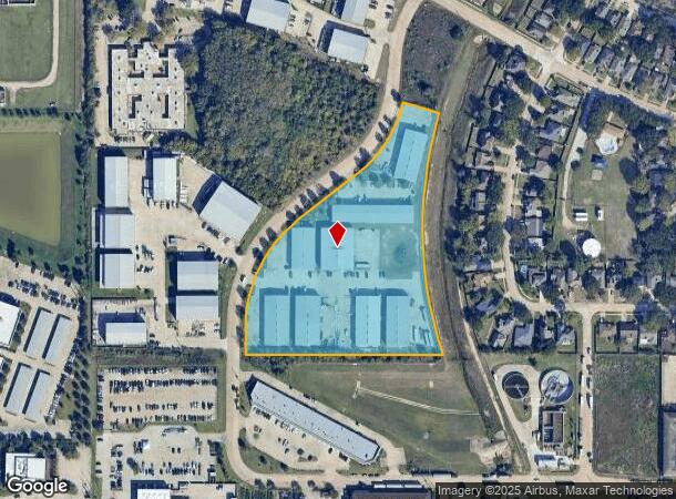
DEMOGRAPHICS near 1402 Vanderwilt Ln
1 Mile
3 Mile
5 Mile
2024 Total Population
14,340
135,114
285,200
2029 Population
14,474
137,887
300,147
Pop Growth 2024-2029
+ 0.93%
+ 2.05%
+ 5.24%
Average Age
35
37
36
2024 Total Households
5,059
45,799
93,947
HH Growth 2024-2029
+ 0.81%
+ 2.05%
+ 5.28%
Median Household Inc
$57,352
$83,133
$88,167
Avg Household Size
2.80
2.90
3.00
2024 Avg HH Vehicles
2.00
2.00
2.00
Median Home Value
$195,793
$240,764
$256,468
Median Year Built
1997
1996
2003
Nearby Places
Map Layers
Map Styles
 Street
 Aerial
- Restaurants
- Banks
- Shops
- Fitness
- Groceries
PUBLIC TRANSPORTATION
AIRPORT
William P Hobby
DRIVE
WALK
Distance
William P Hobby
54 min
36.6 mi
George Bush Intcntl/Houston
DRIVE
WALK
Distance
George Bush Intcntl/Houston
48 min
37.9 mi
Nearby Properties
Address
Land Use
TOTAL SIZE
Lot Size
Zoning
Address
Land Use
TOTAL SIZE
Lot Size
Zoning
695,923 SF
6.63 AC
Address
Land Use
TOTAL SIZE
Lot Size
Zoning
765,465 SF
63.65 AC
Address
Land Use
TOTAL SIZE
Lot Size
Zoning
681,561 SF
7.98 AC
Address
Land Use
TOTAL SIZE
Lot Size
Zoning
614,847 SF
42 AC
Address
Land Use
TOTAL SIZE
Lot Size
Zoning
329,918 SF
19.18 AC
Address
Land Use
TOTAL SIZE
Lot Size
Zoning
439,347 SF
13.50 AC
Address
Land Use
TOTAL SIZE
Lot Size
Zoning
380,278 SF
12.61 AC
Address
Land Use
TOTAL SIZE
Lot Size
Zoning
417,092 SF
17.58 AC
Address
Land Use
TOTAL SIZE
Lot Size
Zoning
891,129 SF
44.39 AC
Address
Land Use
TOTAL SIZE
Lot Size
Zoning
346,736 SF
14.28 AC
Address
Land Use
TOTAL SIZE
Lot Size
Zoning
352,733 SF
13.66 AC
Address
Land Use
TOTAL SIZE
Lot Size
Zoning
455,592 SF
20.95 AC
Address
Land Use
TOTAL SIZE
Lot Size
Zoning
339,835 SF
12.09 AC
Address
Land Use
TOTAL SIZE
Lot Size
Zoning
278,212 SF
8.15 AC
Address
Land Use
TOTAL SIZE
Lot Size
Zoning
361,382 SF
14.60 AC
Address
Land Use
TOTAL SIZE
Lot Size
Zoning
375,757 SF
18.37 AC
Address
Land Use
TOTAL SIZE
Lot Size
Zoning
375,486 SF
12.36 AC
Address
Land Use
TOTAL SIZE
Lot Size
Zoning
297,040 SF
11.64 AC
Address
Land Use
TOTAL SIZE
Lot Size
Zoning
343,605 SF
11.90 AC
Address
Land Use
TOTAL SIZE
Lot Size
Zoning
348,199 SF
16.69 AC
Address
Land Use
TOTAL SIZE
Lot Size
Zoning
319,717 SF
10.45 AC
Address
Land Use
TOTAL SIZE
Lot Size
Zoning
319,341 SF
14.88 AC
Address
Land Use
TOTAL SIZE
Lot Size
Zoning
324,201 SF
12.39 AC
Address
Land Use
TOTAL SIZE
Lot Size
Zoning
290,973 SF
15 AC
Address
Land Use
TOTAL SIZE
Lot Size
Zoning
492,836 SF
30.20 AC
Address
Land Use
TOTAL SIZE
Lot Size
Zoning
272,033 SF
12.74 AC
Address
Land Use
TOTAL SIZE
Lot Size
Zoning
278,684 SF
13 AC
Address
Land Use
TOTAL SIZE
Lot Size
Zoning
395,495 SF
13.83 AC
Address
Land Use
TOTAL SIZE
Lot Size
Zoning
327,793 SF
10.86 AC
Address
Land Use
TOTAL SIZE
Lot Size
Zoning
384,260 SF
18 AC
The World's #1 Commercial Real Estate Marketplace
Connect with us
© 2026 CoStar Group
The information above has been obtained from sources believed reliable. While we do not doubt its accuracy we have not verified it and make no guarantee, warranty or representation about it. It is your responsibility to independently confirm its accuracy and completeness. Any projections, opinions, assumptions, or estimates used are for example only and do not represent the current or future performance of the property. The value of this transaction to you depends on tax and other factors which should be evaluated by your tax, financial, and legal advisors. You and your advisors should conduct a careful, independent investigation of the property to determine to your satisfaction the suitability of the property for your needs.