Property Record
14020 Augustine Herman Hwy, Galena, MD 21635
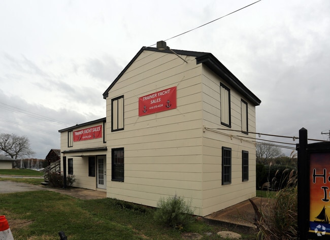

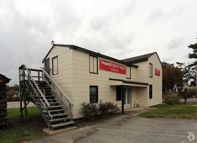
Property Detail
14020 Augustine Herman Hwy
Storebuilding
LOT 14.276 AC 14020 AUGUSTINE HERMAN GEORGETOWN
LM
KENT
AE The base floodplain where base flood elevations are provided. AE Zones are now used on new format FIRMs instead of A1-A30 Zones.
Maryland
2025
14.27 AC
2025
Kent County
950100
Baltimore
3,157 SF
01-006606
NEARBY LISTINGS FOR SALE OR LEASE
-
-
View all Galena listings for sale on LoopNet.com
DEMOGRAPHICS near 14020 Augustine Herman Hwy
1 mile
3 mile
5 mile
2025 Total Population
469
2,239
4,285
2030 Population
474
2,282
4,406
Pop Growth 2025-2030
+ 1.07%
+ 1.92%
+ 2.82%
Average Age
47
45
44
2025 Total Households
209
929
1,722
HH Growth 2025-2030
+ 1.44%
+ 1.83%
+ 2.73%
Median Household Inc
$137,142
$127,312
$115,624
Avg Household Size
2.20
2.40
2.40
2025 Avg HH Vehicles
2.00
2.00
2.00
Median Home Value
$394,230
$383,333
$366,502
Median Year Built
1985
1983
1981
Nearby Places
Map Layers
Map Styles
 Street
 Aerial
Layers
 Traffic
 Biking
Places
Listings with unknown addresses are not visible on the map
- Restaurants
- Banks
- Shops
- Fitness
- Groceries
Nearby Properties
Address
Land Use
TOTAL SIZE
Lot Size
Zoning
Address
Land Use
TOTAL SIZE
Lot Size
Zoning
6.59 AC
RCA
Address
Land Use
TOTAL SIZE
Lot Size
Zoning
58,880 SF
8.30 AC
Address
Land Use
TOTAL SIZE
Lot Size
Zoning
15.69 AC
MB
Address
Land Use
TOTAL SIZE
Lot Size
Zoning
3.01 AC
MB
Address
Land Use
TOTAL SIZE
Lot Size
Zoning
4,500 SF
3.08 AC
C
Address
Land Use
TOTAL SIZE
Lot Size
Zoning
2.16 AC
MB
Address
Land Use
TOTAL SIZE
Lot Size
Zoning
4,560 SF
134.54 AC
AZD
Address
Land Use
TOTAL SIZE
Lot Size
Zoning
7.88 AC
MB
Address
Land Use
TOTAL SIZE
Lot Size
Zoning
840 SF
1.15 AC
HC
Address
Land Use
TOTAL SIZE
Lot Size
Zoning
12,480 SF
1.73 AC
HC
Address
Land Use
TOTAL SIZE
Lot Size
Zoning
2.05 AC
MB
Address
Land Use
TOTAL SIZE
Lot Size
Zoning
605.04 AC
RCDRR
Address
Land Use
TOTAL SIZE
Lot Size
Zoning
5,016 SF
5.67 AC
RR
Address
Land Use
TOTAL SIZE
Lot Size
Zoning
12,677 SF
1.98 AC
CM
Address
Land Use
TOTAL SIZE
Lot Size
Zoning
18,000 SF
10.19 AC
RR
Address
Land Use
TOTAL SIZE
Lot Size
Zoning
1,923 SF
31.80 AC
SAR
Address
Land Use
TOTAL SIZE
Lot Size
Zoning
9,840 SF
6 AC
LM
Address
Land Use
TOTAL SIZE
Lot Size
Zoning
4,964 SF
13.14 AC
RR
Address
Land Use
TOTAL SIZE
Lot Size
Zoning
2,547 SF
1.87 AC
HC
Address
Land Use
TOTAL SIZE
Lot Size
Zoning
11,780 SF
1.46 AC
R1
Address
Land Use
TOTAL SIZE
Lot Size
Zoning
8,007 SF
1.40 AC
Address
Land Use
TOTAL SIZE
Lot Size
Zoning
2,016 SF
3.42 AC
CAR
Address
Land Use
TOTAL SIZE
Lot Size
Zoning
24,240 SF
2.91 AC
R-2
Address
Land Use
TOTAL SIZE
Lot Size
Zoning
10,640 SF
1.65 AC
Address
Land Use
TOTAL SIZE
Lot Size
Zoning
3,270 SF
126.40 AC
MH
Address
Land Use
TOTAL SIZE
Lot Size
Zoning
5.36 AC
SAR
Address
Land Use
TOTAL SIZE
Lot Size
Zoning
4.34 AC
RR
Address
Land Use
TOTAL SIZE
Lot Size
Zoning
3,200 SF
8.65 AC
V
Address
Land Use
TOTAL SIZE
Lot Size
Zoning
4,536 SF
0.78 AC
C-1
The World's #1 Commercial Real Estate Marketplace
Connect with us
© 2026 CoStar Group
The information above has been obtained from sources believed reliable. While we do not doubt its accuracy we have not verified it and make no guarantee, warranty or representation about it. It is your responsibility to independently confirm its accuracy and completeness. Any projections, opinions, assumptions, or estimates used are for example only and do not represent the current or future performance of the property. The value of this transaction to you depends on tax and other factors which should be evaluated by your tax, financial, and legal advisors. You and your advisors should conduct a careful, independent investigation of the property to determine to your satisfaction the suitability of the property for your needs.