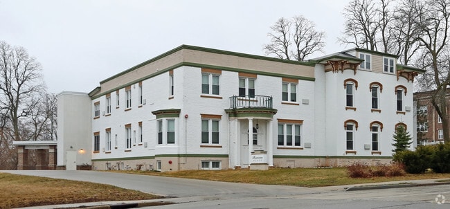
Property Record
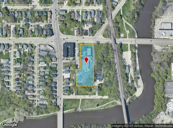
1403 W 6Th St, Racine, WI 53404

NEARBY LISTINGS FOR SALE OR LEASE
Property Detail
1403 W 6Th St
276-000007323000
Nissen And Freemans Subdivision
Commercialnec
NE 1/4 SECTION 17-3-23 PT DESC AS PCL I VOL 2499 RECS PGS 412-417, N OF RIVERVIEW TERR, S OF W SIXTH ST, E OF N MEMORIAL DR +
X
Racine
55101C0231E
Wisconsin
2024
1.45 AC
2024
Downtown Racine
000500
Milwaukee/Madison
28,201 SF
Racine, WI
DEMOGRAPHICS near 1403 W 6Th St
1 Mile
3 Mile
5 Mile
2024 Total Population
18,469
82,170
118,535
2029 Population
18,448
81,541
117,585
Pop Growth 2024-2029
(0.11%)
(0.77%)
(0.80%)
Average Age
35
38
40
2024 Total Households
7,177
33,370
48,559
HH Growth 2024-2029
(0.15%)
(0.83%)
(0.85%)
Median Household Inc
$35,356
$51,977
$59,916
Avg Household Size
2.40
2.40
2.30
2024 Avg HH Vehicles
1.00
2.00
2.00
Median Home Value
$108,134
$151,841
$179,302
Median Year Built
1947
1953
1961
Nearby Places
Map Layers
Map Styles
 Street
 Aerial
- Restaurants
- Banks
- Shops
- Fitness
- Groceries
PUBLIC TRANSPORTATION
COMMUTER RAIL
Sturtevant Amtrak Station (Hiawatha Service - Amtrak)
DRIVE
WALK
Distance
Sturtevant Amtrak Station (Hiawatha Service - Amtrak)
13 min
6.6 mi
AIRPORT
General Mitchell International
DRIVE
WALK
Distance
General Mitchell International
35 min
19.6 mi
Freight Ports
Port Milwaukee
DRIVE
WALK
Distance
Port Milwaukee
40 min
25.6 mi
Nearby Properties
Address
Land Use
TOTAL SIZE
Lot Size
Zoning
Address
Land Use
TOTAL SIZE
Lot Size
Zoning
61,744 SF
42.23 AC
OI
Address
Land Use
TOTAL SIZE
Lot Size
Zoning
14.11 AC
I2
Address
Land Use
TOTAL SIZE
Lot Size
Zoning
180,831 SF
1.49 AC
B4
Address
Land Use
TOTAL SIZE
Lot Size
Zoning
9,982 SF
0.39 AC
B4
Address
Land Use
TOTAL SIZE
Lot Size
Zoning
33.40 AC
I2
Address
Land Use
TOTAL SIZE
Lot Size
Zoning
98.81 AC
Address
Land Use
TOTAL SIZE
Lot Size
Zoning
Address
Land Use
TOTAL SIZE
Lot Size
Zoning
3.54 AC
B4
Address
Land Use
TOTAL SIZE
Lot Size
Zoning
Address
Land Use
TOTAL SIZE
Lot Size
Zoning
22.72 AC
Address
Land Use
TOTAL SIZE
Lot Size
Zoning
58,485 SF
19.71 AC
I2
Address
Land Use
TOTAL SIZE
Lot Size
Zoning
Address
Land Use
TOTAL SIZE
Lot Size
Zoning
Address
Land Use
TOTAL SIZE
Lot Size
Zoning
Address
Land Use
TOTAL SIZE
Lot Size
Zoning
23.15 AC
I2
Address
Land Use
TOTAL SIZE
Lot Size
Zoning
102,312 SF
9.92 AC
B2
Address
Land Use
TOTAL SIZE
Lot Size
Zoning
105,550 SF
13.43 AC
Address
Land Use
TOTAL SIZE
Lot Size
Zoning
Address
Land Use
TOTAL SIZE
Lot Size
Zoning
44,439 SF
1.75 AC
B4
Address
Land Use
TOTAL SIZE
Lot Size
Zoning
8.08 AC
Address
Land Use
TOTAL SIZE
Lot Size
Zoning
5.04 AC
B-3
Address
Land Use
TOTAL SIZE
Lot Size
Zoning
71,184 SF
1.05 AC
B4
Address
Land Use
TOTAL SIZE
Lot Size
Zoning
12.10 AC
I2
Address
Land Use
TOTAL SIZE
Lot Size
Zoning
78,748 SF
0.88 AC
I2
Address
Land Use
TOTAL SIZE
Lot Size
Zoning
Address
Land Use
TOTAL SIZE
Lot Size
Zoning
6.77 AC
I2IP
Address
Land Use
TOTAL SIZE
Lot Size
Zoning
209,664 SF
2.82 AC
B5
Address
Land Use
TOTAL SIZE
Lot Size
Zoning
Address
Land Use
TOTAL SIZE
Lot Size
Zoning
10.12 AC
Address
Land Use
TOTAL SIZE
Lot Size
Zoning
21.66 AC
I2
The World's #1 Commercial Real Estate Marketplace
Connect with us
© 2025 CoStar Group
The information above has been obtained from sources believed reliable. While we do not doubt its accuracy we have not verified it and make no guarantee, warranty or representation about it. It is your responsibility to independently confirm its accuracy and completeness. Any projections, opinions, assumptions, or estimates used are for example only and do not represent the current or future performance of the property. The value of this transaction to you depends on tax and other factors which should be evaluated by your tax, financial, and legal advisors. You and your advisors should conduct a careful, independent investigation of the property to determine to your satisfaction the suitability of the property for your needs.