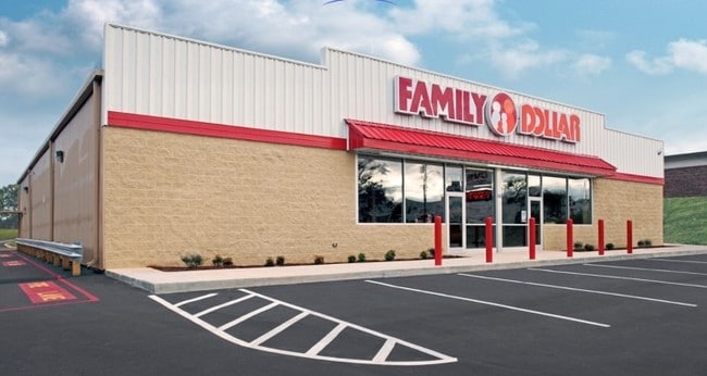
Property Record
1403 Wurst Rd, Ocoee, FL 34761

Property Detail
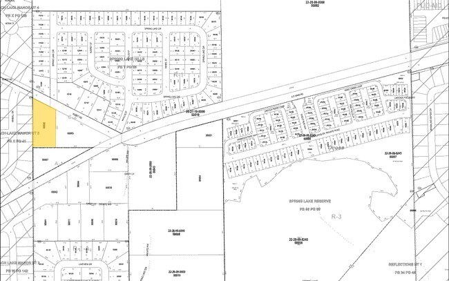
1403 Wurst Rd
09-2228-0000-00-020
PART OF NW1/4 OF SW1/4 SW OF RD & NWLY OF RR (LESS E 400 FT THEREOF) IN SEC 09-22-28
Storebuilding
Orange
C-2
Florida
B and X Area of moderate flood hazard, usually the area between the limits of the 100-year and 500-year floods.
20
2025
1.17 AC
2025
West Colonial
015003
Orlando
8,656 SF
Orlando-Kissimmee-Sanford, FL
NEARBY LISTINGS FOR SALE OR LEASE
DEMOGRAPHICS near 1403 Wurst Rd
1 mile
3 mile
5 mile
2025 Total Population
13,514
80,606
211,253
2030 Population
14,736
87,556
229,463
Pop Growth 2025-2030
+ 9.04%
+ 8.62%
+ 8.62%
Average Age
39
39
39
2025 Total Households
4,303
26,944
71,310
HH Growth 2025-2030
+ 9.41%
+ 9.01%
+ 9.04%
Median Household Inc
$86,636
$83,994
$74,663
Avg Household Size
3.10
2.90
2.90
2025 Avg HH Vehicles
2.00
2.00
2.00
Median Home Value
$326,539
$367,221
$367,122
Median Year Built
1987
1993
1991
Nearby Places
Map Layers
Map Styles
 Street
 Aerial
Transit
 Traffic
 Biking
Places
Listings with unknown addresses are not visible on the map
- Restaurants
- Banks
- Shops
- Fitness
- Groceries
PUBLIC TRANSPORTATION
AIRPORT
Orlando International
Drive
Walk
Distance
Orlando International
39 min
24.5 mi
Orlando Sanford International
Drive
Walk
Distance
Orlando Sanford International
49 min
29.9 mi
Nearby Properties
Address
Land Use
TOTAL SIZE
Lot Size
Zoning
Address
Land Use
TOTAL SIZE
Lot Size
Zoning
840,260 SF
65.85 AC
C-2
Address
Land Use
TOTAL SIZE
Lot Size
Zoning
481,795 SF
16.56 AC
I-1
Address
Land Use
TOTAL SIZE
Lot Size
Zoning
669,041 SF
43.79 AC
I-1
Address
Land Use
TOTAL SIZE
Lot Size
Zoning
321,759 SF
PUD-HD
Address
Land Use
TOTAL SIZE
Lot Size
Zoning
668,180 SF
52.21 AC
PUD-PU
Address
Land Use
TOTAL SIZE
Lot Size
Zoning
368,910 SF
14.02 AC
CAPUD
Address
Land Use
TOTAL SIZE
Lot Size
Zoning
347,605 SF
9.10 AC
C-2
Address
Land Use
TOTAL SIZE
Lot Size
Zoning
446,425 SF
25.15 AC
PUD-IND
Address
Land Use
TOTAL SIZE
Lot Size
Zoning
359,382 SF
16.38 AC
PUD
Address
Land Use
TOTAL SIZE
Lot Size
Zoning
169,070 SF
12 AC
F-OCO-PUD-
Address
Land Use
TOTAL SIZE
Lot Size
Zoning
167,285 SF
164.77 AC
C-3
Address
Land Use
TOTAL SIZE
Lot Size
Zoning
314,643 SF
38.04 AC
PUD
Address
Land Use
TOTAL SIZE
Lot Size
Zoning
263,067 SF
41.46 AC
P-D
Address
Land Use
TOTAL SIZE
Lot Size
Zoning
265,223 SF
1.89 AC
R-3
Address
Land Use
TOTAL SIZE
Lot Size
Zoning
196,924 SF
2.53 AC
P-S
Address
Land Use
TOTAL SIZE
Lot Size
Zoning
493,556 SF
28.89 AC
I-2
Address
Land Use
TOTAL SIZE
Lot Size
Zoning
238,004 SF
13.11 AC
R-3
Address
Land Use
TOTAL SIZE
Lot Size
Zoning
221,959 SF
10.82 AC
P-D
Address
Land Use
TOTAL SIZE
Lot Size
Zoning
352,671 SF
25.54 AC
P-D
Address
Land Use
TOTAL SIZE
Lot Size
Zoning
179,371 SF
21.52 AC
A-1
Address
Land Use
TOTAL SIZE
Lot Size
Zoning
261,608 SF
21.73 AC
C-2
Address
Land Use
TOTAL SIZE
Lot Size
Zoning
183,582 SF
16.82 AC
C-2
Address
Land Use
TOTAL SIZE
Lot Size
Zoning
271,821 SF
20.05 AC
R-3
Address
Land Use
TOTAL SIZE
Lot Size
Zoning
149,795 SF
41.80 AC
A-1
Address
Land Use
TOTAL SIZE
Lot Size
Zoning
169,734 SF
2.46 AC
R-3
Address
Land Use
TOTAL SIZE
Lot Size
Zoning
137,419 SF
20.08 AC
A-1
Address
Land Use
TOTAL SIZE
Lot Size
Zoning
323,369 SF
5.75 AC
R-3
Address
Land Use
TOTAL SIZE
Lot Size
Zoning
117,421 SF
19.23 AC
R-1A
Address
Land Use
TOTAL SIZE
Lot Size
Zoning
95,903 SF
15.98 AC
PUD-LD
Address
Land Use
TOTAL SIZE
Lot Size
Zoning
157,634 SF
16.29 AC
A-1
The World's #1 Commercial Real Estate Marketplace
Connect with us
© 2026 CoStar Group
The information above has been obtained from sources believed reliable. While we do not doubt its accuracy we have not verified it and make no guarantee, warranty or representation about it. It is your responsibility to independently confirm its accuracy and completeness. Any projections, opinions, assumptions, or estimates used are for example only and do not represent the current or future performance of the property. The value of this transaction to you depends on tax and other factors which should be evaluated by your tax, financial, and legal advisors. You and your advisors should conduct a careful, independent investigation of the property to determine to your satisfaction the suitability of the property for your needs.