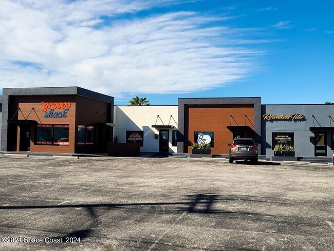
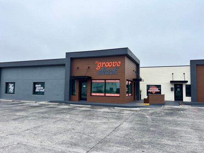
Property Record
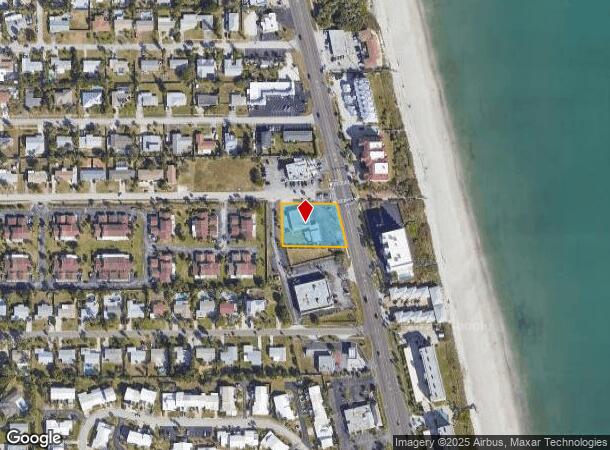
1404 Highway A1a, Satellite Beach, FL 32937
NEARBY LISTINGS FOR SALE OR LEASE
-
-
View all Satellite Beach listings for sale on LoopNet.com
Property Detail
1404 Highway A1a
27-37-01-00-00266.0-0000.00
PART OF NW 1/4 OF NW 1/4 AS DES IN ORB 659 PG 687
Officebuilding
Brevard
X
Florida
12009C0537H
1
2024
0.69 AC
2025
Brevard County
066600
Orlando
6,556 SF
Palm Bay-Melbourne-Titusville, FL
DEMOGRAPHICS near 1404 Highway A1a
1 Mile
3 Mile
5 Mile
2024 Total Population
8,480
31,410
70,245
2029 Population
9,218
34,343
76,490
Pop Growth 2024-2029
+ 8.70%
+ 9.34%
+ 8.89%
Average Age
44
46
45
2024 Total Households
3,490
13,704
30,978
HH Growth 2024-2029
+ 8.48%
+ 9.14%
+ 8.66%
Median Household Inc
$98,494
$84,091
$73,336
Avg Household Size
2.40
2.30
2.20
2024 Avg HH Vehicles
2.00
2.00
2.00
Median Home Value
$358,290
$368,081
$317,340
Median Year Built
1972
1976
1980
Nearby Places
Map Layers
Map Styles
 Street
 Aerial
- Restaurants
- Banks
- Shops
- Fitness
- Groceries
PUBLIC TRANSPORTATION
AIRPORT
Melbourne Orlando International
DRIVE
WALK
Distance
Melbourne Orlando International
23 min
10.2 mi
Freight Ports
Port Canaveral
DRIVE
WALK
Distance
Port Canaveral
33 min
16.8 mi
SALE & LEASE HISTORY
LISTING DATE
SALE/LEASE

Sep 18, 2019
For Sale
Jan 17, 2025
For Sale
Dec 18, 2019
For Lease
Nearby Properties
Address
Land Use
TOTAL SIZE
Lot Size
Zoning
Address
Land Use
TOTAL SIZE
Lot Size
Zoning
511,907 SF
75.60 AC
ITU
Address
Land Use
TOTAL SIZE
Lot Size
Zoning
289,263 SF
13.96 AC
R2
Address
Land Use
TOTAL SIZE
Lot Size
Zoning
225,168 SF
7.06 AC
R3
Address
Land Use
TOTAL SIZE
Lot Size
Zoning
173,965 SF
4.28 AC
C1
Address
Land Use
TOTAL SIZE
Lot Size
Zoning
169,387 SF
28.25 AC
INL
Address
Land Use
TOTAL SIZE
Lot Size
Zoning
252,942 SF
29.76 AC
R3
Address
Land Use
TOTAL SIZE
Lot Size
Zoning
192,888 SF
5.66 AC
Address
Land Use
TOTAL SIZE
Lot Size
Zoning
162,759 SF
8.49 AC
RU230
Address
Land Use
TOTAL SIZE
Lot Size
Zoning
182,969 SF
14.64 AC
B1
Address
Land Use
TOTAL SIZE
Lot Size
Zoning
94,097 SF
3.21 AC
R2
Address
Land Use
TOTAL SIZE
Lot Size
Zoning
118,607 SF
9.67 AC
CP
Address
Land Use
TOTAL SIZE
Lot Size
Zoning
106,333 SF
2.52 AC
B1
Address
Land Use
TOTAL SIZE
Lot Size
Zoning
7.02 AC
ITU
Address
Land Use
TOTAL SIZE
Lot Size
Zoning
75,076 SF
3.67 AC
RU215
Address
Land Use
TOTAL SIZE
Lot Size
Zoning
152,762 SF
13.70 AC
C
Address
Land Use
TOTAL SIZE
Lot Size
Zoning
2,792 SF
6.36 AC
ITU
Address
Land Use
TOTAL SIZE
Lot Size
Zoning
144,052 SF
13.28 AC
B1
Address
Land Use
TOTAL SIZE
Lot Size
Zoning
742 SF
2.04 AC
GML
Address
Land Use
TOTAL SIZE
Lot Size
Zoning
52,325 SF
2.40 AC
C1
Address
Land Use
TOTAL SIZE
Lot Size
Zoning
55,552 SF
1.50 AC
Address
Land Use
TOTAL SIZE
Lot Size
Zoning
72,781 SF
9.54 AC
IN(L)
Address
Land Use
TOTAL SIZE
Lot Size
Zoning
99,628 SF
9.97 AC
CP
Address
Land Use
TOTAL SIZE
Lot Size
Zoning
108,296 SF
3.52 AC
Address
Land Use
TOTAL SIZE
Lot Size
Zoning
33,556 SF
1.04 AC
R3
Address
Land Use
TOTAL SIZE
Lot Size
Zoning
1,043 SF
5.73 AC
GML
Address
Land Use
TOTAL SIZE
Lot Size
Zoning
78,050 SF
6.26 AC
CP
Address
Land Use
TOTAL SIZE
Lot Size
Zoning
56,927 SF
6.87 AC
CP
Address
Land Use
TOTAL SIZE
Lot Size
Zoning
66,611 SF
14 AC
P2
Address
Land Use
TOTAL SIZE
Lot Size
Zoning
27,825 SF
5.70 AC
B1
Address
Land Use
TOTAL SIZE
Lot Size
Zoning
63,316 SF
4.03 AC
R210
The World's #1 Commercial Real Estate Marketplace
Connect with us
© 2025 CoStar Group
The information above has been obtained from sources believed reliable. While we do not doubt its accuracy we have not verified it and make no guarantee, warranty or representation about it. It is your responsibility to independently confirm its accuracy and completeness. Any projections, opinions, assumptions, or estimates used are for example only and do not represent the current or future performance of the property. The value of this transaction to you depends on tax and other factors which should be evaluated by your tax, financial, and legal advisors. You and your advisors should conduct a careful, independent investigation of the property to determine to your satisfaction the suitability of the property for your needs.