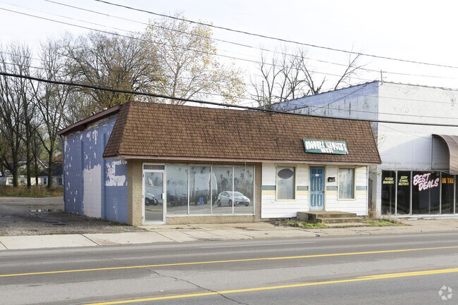
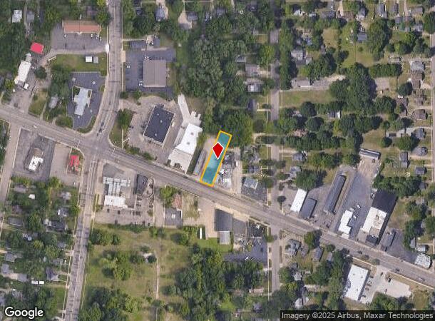
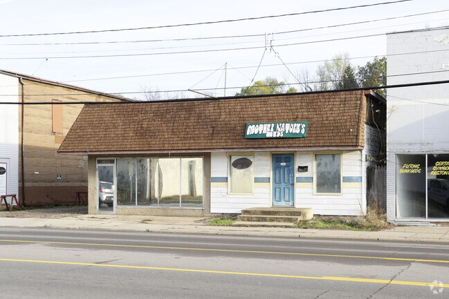
Property Record
1404 Michigan Ave W, Battle Creek, MI 49037
NEARBY LISTINGS FOR SALE OR LEASE
Property Detail
1404 Michigan Ave W
Battle Creek, MI
Urbandale
8610-00-009-0
PLAT OF URBANDALE SELY 51 FT OF LOT 5
Storebuilding
Calhoun
X
Michigan
26025C0176C
5
0
0.25 AC
2025
Battle Crk/W Calhoun Cnty
001100
West Michigan
1,654 SF
DEMOGRAPHICS near 1404 Michigan Ave W
1 Mile
3 Mile
5 Mile
2024 Total Population
4,661
33,503
66,636
2029 Population
4,593
33,295
66,047
Pop Growth 2024-2029
(1.46%)
(0.62%)
(0.88%)
Average Age
40
39
39
2024 Total Households
2,132
13,882
27,035
HH Growth 2024-2029
(1.45%)
(0.71%)
(0.93%)
Median Household Inc
$42,226
$41,795
$47,766
Avg Household Size
2.20
2.30
2.30
2024 Avg HH Vehicles
1.00
1.00
2.00
Median Home Value
$80,087
$83,140
$108,657
Median Year Built
1960
1956
1956
Nearby Places
Map Layers
Map Styles
 Street
 Aerial
- Restaurants
- Banks
- Shops
- Fitness
- Groceries
PUBLIC TRANSPORTATION
COMMUTER RAIL
Battle Creek (Blue Water - Amtrak, Wolverine - Amtrak)
DRIVE
WALK
Distance
Battle Creek (Blue Water - Amtrak, Wolverine - Amtrak)
4 min
3.0 mi
AIRPORT
Kalamazoo/Battle Creek International
DRIVE
WALK
Distance
Kalamazoo/Battle Creek International
34 min
23.3 mi
Freight Ports
Port of Toledo
DRIVE
WALK
Distance
Port of Toledo
154 min
125.7 mi
Nearby Properties
Address
Land Use
TOTAL SIZE
Lot Size
Zoning
Address
Land Use
TOTAL SIZE
Lot Size
Zoning
337,297 SF
18.85 AC
T4
Address
Land Use
TOTAL SIZE
Lot Size
Zoning
1,279,617 SF
86.82 AC
I2
Address
Land Use
TOTAL SIZE
Lot Size
Zoning
291,206 SF
18.98 AC
T4
Address
Land Use
TOTAL SIZE
Lot Size
Zoning
183,198 SF
17.72 AC
RM-1
Address
Land Use
TOTAL SIZE
Lot Size
Zoning
174,064 SF
T4
Address
Land Use
TOTAL SIZE
Lot Size
Zoning
52,764 SF
3.52 AC
AG
Address
Land Use
TOTAL SIZE
Lot Size
Zoning
123,060 SF
10.53 AC
I2
Address
Land Use
TOTAL SIZE
Lot Size
Zoning
308,111 SF
50.82 AC
I2
Address
Land Use
TOTAL SIZE
Lot Size
Zoning
188,711 SF
44.81 AC
I2
Address
Land Use
TOTAL SIZE
Lot Size
Zoning
150,018 SF
13.12 AC
MFR
Address
Land Use
TOTAL SIZE
Lot Size
Zoning
129,598 SF
0.62 AC
T5
Address
Land Use
TOTAL SIZE
Lot Size
Zoning
113,070 SF
6.35 AC
MFR
Address
Land Use
TOTAL SIZE
Lot Size
Zoning
191,099 SF
29.08 AC
I2
Address
Land Use
TOTAL SIZE
Lot Size
Zoning
199,664 SF
24.70 AC
I2
Address
Land Use
TOTAL SIZE
Lot Size
Zoning
34,452 SF
1.12 AC
T4
Address
Land Use
TOTAL SIZE
Lot Size
Zoning
96,142 SF
13.73 AC
MFR
Address
Land Use
TOTAL SIZE
Lot Size
Zoning
161,104 SF
38.28 AC
I2
Address
Land Use
TOTAL SIZE
Lot Size
Zoning
196,225 SF
17.73 AC
I2
Address
Land Use
TOTAL SIZE
Lot Size
Zoning
49,412 SF
Address
Land Use
TOTAL SIZE
Lot Size
Zoning
43,780 SF
I2
Address
Land Use
TOTAL SIZE
Lot Size
Zoning
127,365 SF
9 AC
I2
Address
Land Use
TOTAL SIZE
Lot Size
Zoning
111,744 SF
9.75 AC
RM-1
Address
Land Use
TOTAL SIZE
Lot Size
Zoning
99,816 SF
22.44 AC
I2
Address
Land Use
TOTAL SIZE
Lot Size
Zoning
239,876 SF
30.39 AC
I2
Address
Land Use
TOTAL SIZE
Lot Size
Zoning
123,544 SF
17.11 AC
I2
Address
Land Use
TOTAL SIZE
Lot Size
Zoning
53,501 SF
7.34 AC
B1
Address
Land Use
TOTAL SIZE
Lot Size
Zoning
98,360 SF
0.31 AC
T5
Address
Land Use
TOTAL SIZE
Lot Size
Zoning
4,036 SF
69.30 AC
RB MED
Address
Land Use
TOTAL SIZE
Lot Size
Zoning
85,800 SF
Address
Land Use
TOTAL SIZE
Lot Size
Zoning
50,000 SF
8.48 AC
R-2
The World's #1 Commercial Real Estate Marketplace
Connect with us
© 2025 CoStar Group
The information above has been obtained from sources believed reliable. While we do not doubt its accuracy we have not verified it and make no guarantee, warranty or representation about it. It is your responsibility to independently confirm its accuracy and completeness. Any projections, opinions, assumptions, or estimates used are for example only and do not represent the current or future performance of the property. The value of this transaction to you depends on tax and other factors which should be evaluated by your tax, financial, and legal advisors. You and your advisors should conduct a careful, independent investigation of the property to determine to your satisfaction the suitability of the property for your needs.