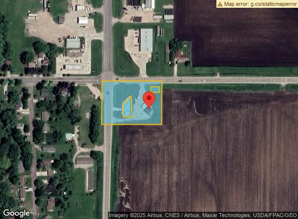
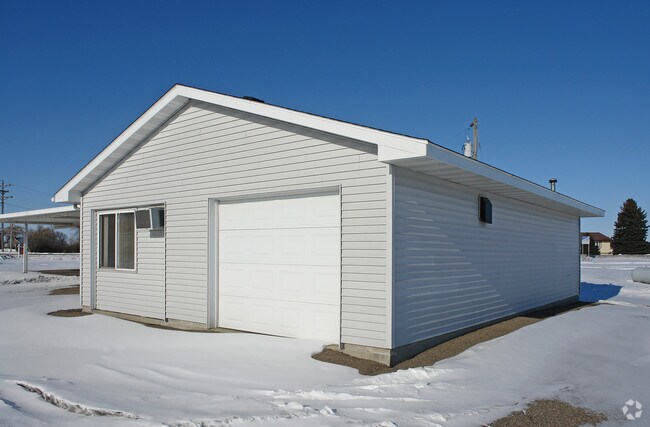
Property Record
14040 State Highway 30, New Richland, MN 56072

NEARBY LISTINGS FOR SALE OR LEASE
-
-
View all New Richland listings for sale on LoopNet.com
Property Detail
14040 State Highway 30
Commercialnec
SECT-21 TWP-105 RANGE-022 N250.75 FT OF W347.40 FT OF NW1/4 OF NW1/4 EX .175AC
X
Waseca
27161C0300C
Minnesota
2025
0.18 AC
2024
Minnesota South Area
790200
Other Market Areas
936 SF
07.021.0600
DEMOGRAPHICS near 14040 State Highway 30
1 Mile
3 Mile
5 Mile
2024 Total Population
1,245
1,446
1,895
2029 Population
1,237
1,434
1,874
Pop Growth 2024-2029
(0.64%)
(0.83%)
(1.11%)
Average Age
42
42
43
2024 Total Households
473
556
740
HH Growth 2024-2029
(0.63%)
(0.72%)
(1.08%)
Median Household Inc
$51,389
$57,999
$63,956
Avg Household Size
2.50
2.50
2.50
2024 Avg HH Vehicles
2.00
2.00
2.00
Median Home Value
$134,104
$147,644
$168,722
Median Year Built
1955
1955
1955
Nearby Places
Map Layers
Map Styles
 Street
 Aerial
- Restaurants
- Banks
- Shops
- Fitness
- Groceries
Nearby Properties
Address
Land Use
TOTAL SIZE
Lot Size
Zoning
Address
Land Use
TOTAL SIZE
Lot Size
Zoning
1,232 SF
308.56 AC
Address
Land Use
TOTAL SIZE
Lot Size
Zoning
157.98 AC
Address
Land Use
TOTAL SIZE
Lot Size
Zoning
149.78 AC
Address
Land Use
TOTAL SIZE
Lot Size
Zoning
884 SF
146.07 AC
Address
Land Use
TOTAL SIZE
Lot Size
Zoning
1,872 SF
60 AC
Address
Land Use
TOTAL SIZE
Lot Size
Zoning
2,597 SF
136.09 AC
Address
Land Use
TOTAL SIZE
Lot Size
Zoning
140.84 AC
Address
Land Use
TOTAL SIZE
Lot Size
Zoning
1,926 SF
131.98 AC
Address
Land Use
TOTAL SIZE
Lot Size
Zoning
16.80 AC
Address
Land Use
TOTAL SIZE
Lot Size
Zoning
112.35 AC
Address
Land Use
TOTAL SIZE
Lot Size
Zoning
928 SF
108.30 AC
Address
Land Use
TOTAL SIZE
Lot Size
Zoning
52,166 SF
15.30 AC
Address
Land Use
TOTAL SIZE
Lot Size
Zoning
2.55 AC
Address
Land Use
TOTAL SIZE
Lot Size
Zoning
1,040 SF
73.37 AC
Address
Land Use
TOTAL SIZE
Lot Size
Zoning
Address
Land Use
TOTAL SIZE
Lot Size
Zoning
74.38 AC
Address
Land Use
TOTAL SIZE
Lot Size
Zoning
832 SF
80 AC
Address
Land Use
TOTAL SIZE
Lot Size
Zoning
1,376 SF
73.63 AC
Address
Land Use
TOTAL SIZE
Lot Size
Zoning
Address
Land Use
TOTAL SIZE
Lot Size
Zoning
5,704 SF
0.52 AC
Address
Land Use
TOTAL SIZE
Lot Size
Zoning
1,248 SF
67.13 AC
Address
Land Use
TOTAL SIZE
Lot Size
Zoning
45.89 AC
Address
Land Use
TOTAL SIZE
Lot Size
Zoning
Address
Land Use
TOTAL SIZE
Lot Size
Zoning
1.20 AC
Address
Land Use
TOTAL SIZE
Lot Size
Zoning
3,535 SF
0.34 AC
Address
Land Use
TOTAL SIZE
Lot Size
Zoning
Address
Land Use
TOTAL SIZE
Lot Size
Zoning
9,354 SF
2.71 AC
Address
Land Use
TOTAL SIZE
Lot Size
Zoning
768 SF
37.50 AC
The World's #1 Commercial Real Estate Marketplace
Connect with us
© 2025 CoStar Group
The information above has been obtained from sources believed reliable. While we do not doubt its accuracy we have not verified it and make no guarantee, warranty or representation about it. It is your responsibility to independently confirm its accuracy and completeness. Any projections, opinions, assumptions, or estimates used are for example only and do not represent the current or future performance of the property. The value of this transaction to you depends on tax and other factors which should be evaluated by your tax, financial, and legal advisors. You and your advisors should conduct a careful, independent investigation of the property to determine to your satisfaction the suitability of the property for your needs.