Property Record
1405 4Th St, Charleston, IL 61920
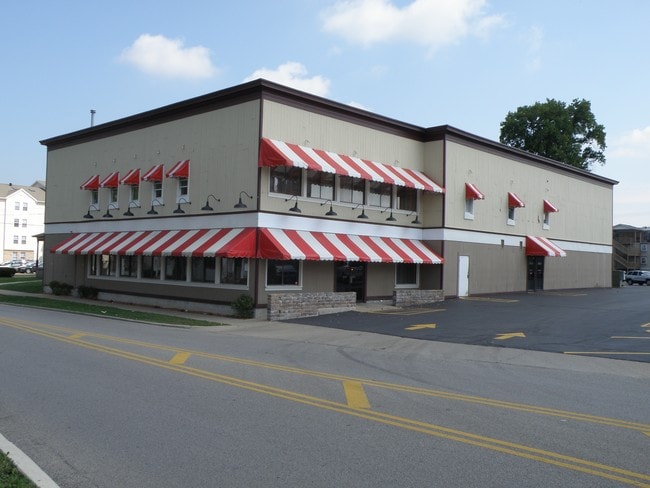


Property Detail
1405 4Th St
Charleston-Mattoon, IL
A R BAILS ADD BLK 1 LOTS 9 & 10 115 FT W END LOT 9 NW 1/4 SEC 14 T12N R09E KRACKERS
02-1-04843-000
Coles
Commercialnec
Illinois
B and X Area of moderate flood hazard, usually the area between the limits of the 100-year and 500-year floods.
9,10
2024
0.46 AC
2024
Effingham/Central Illinois Area
000702
Other Market Areas
14,644 SF
NEARBY LISTINGS FOR SALE OR LEASE
-
-
View all Charleston listings for lease on LoopNet.com
DEMOGRAPHICS near 1405 4Th St
1 mile
3 mile
5 mile
2025 Total Population
12,288
18,921
20,073
2030 Population
12,227
18,741
19,874
Pop Growth 2025-2030
(0.50%)
(0.95%)
(0.99%)
Average Age
35
37
38
2025 Total Households
4,805
7,547
8,042
HH Growth 2025-2030
(0.87%)
(1.27%)
(1.31%)
Median Household Inc
$47,609
$51,334
$53,413
Avg Household Size
2.10
2.10
2.10
2025 Avg HH Vehicles
2.00
2.00
2.00
Median Home Value
$134,473
$143,426
$145,691
Median Year Built
1977
1977
1978
Nearby Places
Map Layers
Map Styles
 Street
 Aerial
Layers
 Traffic
 Biking
Places
Listings with unknown addresses are not visible on the map
- Restaurants
- Banks
- Shops
- Fitness
- Groceries
SALE & LEASE HISTORY
LISTING DATE
SALE/LEASE

Sep 25, 2016
For Lease
Sep 24, 2016
For Sale
Nearby Properties
Address
Land Use
TOTAL SIZE
Lot Size
Zoning
Address
Land Use
TOTAL SIZE
Lot Size
Zoning
151,533 SF
14.62 AC
Address
Land Use
TOTAL SIZE
Lot Size
Zoning
2.11 AC
Address
Land Use
TOTAL SIZE
Lot Size
Zoning
24,687 SF
15.30 AC
Address
Land Use
TOTAL SIZE
Lot Size
Zoning
2,280 SF
36.19 AC
Address
Land Use
TOTAL SIZE
Lot Size
Zoning
51,294 SF
2 AC
Address
Land Use
TOTAL SIZE
Lot Size
Zoning
12,918 SF
1.21 AC
Address
Land Use
TOTAL SIZE
Lot Size
Zoning
29,370 SF
1.05 AC
Address
Land Use
TOTAL SIZE
Lot Size
Zoning
3.09 AC
Address
Land Use
TOTAL SIZE
Lot Size
Zoning
12,000 SF
6.95 AC
Address
Land Use
TOTAL SIZE
Lot Size
Zoning
2,920 SF
8.92 AC
Address
Land Use
TOTAL SIZE
Lot Size
Zoning
11,211 SF
40 AC
Address
Land Use
TOTAL SIZE
Lot Size
Zoning
23,366 SF
5.88 AC
Address
Land Use
TOTAL SIZE
Lot Size
Zoning
1,972 SF
7.15 AC
Address
Land Use
TOTAL SIZE
Lot Size
Zoning
34.03 AC
Address
Land Use
TOTAL SIZE
Lot Size
Zoning
32,747 SF
2.33 AC
Address
Land Use
TOTAL SIZE
Lot Size
Zoning
5,692 SF
1.17 AC
Address
Land Use
TOTAL SIZE
Lot Size
Zoning
94,968 SF
20 AC
Address
Land Use
TOTAL SIZE
Lot Size
Zoning
Address
Land Use
TOTAL SIZE
Lot Size
Zoning
6,528 SF
3.15 AC
Address
Land Use
TOTAL SIZE
Lot Size
Zoning
84,602 SF
1.28 AC
Address
Land Use
TOTAL SIZE
Lot Size
Zoning
21,728 SF
1.03 AC
Address
Land Use
TOTAL SIZE
Lot Size
Zoning
14,423 SF
63.19 AC
Address
Land Use
TOTAL SIZE
Lot Size
Zoning
17,212 SF
3.60 AC
Address
Land Use
TOTAL SIZE
Lot Size
Zoning
32,226 SF
0.45 AC
Address
Land Use
TOTAL SIZE
Lot Size
Zoning
5,904 SF
1.97 AC
Address
Land Use
TOTAL SIZE
Lot Size
Zoning
11,805 SF
10.70 AC
Address
Land Use
TOTAL SIZE
Lot Size
Zoning
56,824 SF
5.04 AC
Address
Land Use
TOTAL SIZE
Lot Size
Zoning
7,740 SF
3.12 AC
Address
Land Use
TOTAL SIZE
Lot Size
Zoning
0.98 AC
Address
Land Use
TOTAL SIZE
Lot Size
Zoning
2.06 AC
The World's #1 Commercial Real Estate Marketplace
Connect with us
© 2026 CoStar Group
The information above has been obtained from sources believed reliable. While we do not doubt its accuracy we have not verified it and make no guarantee, warranty or representation about it. It is your responsibility to independently confirm its accuracy and completeness. Any projections, opinions, assumptions, or estimates used are for example only and do not represent the current or future performance of the property. The value of this transaction to you depends on tax and other factors which should be evaluated by your tax, financial, and legal advisors. You and your advisors should conduct a careful, independent investigation of the property to determine to your satisfaction the suitability of the property for your needs.