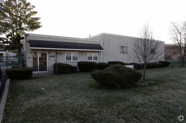
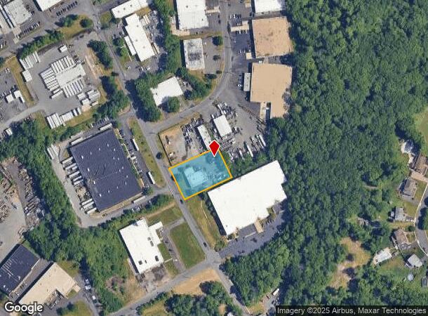
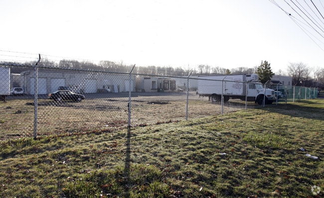
Property Record
1405 Bridgewater Rd, Bensalem, PA 19020

Current Lease Availabilities
NEARBY LISTINGS FOR SALE OR LEASE
Property Detail
1405 Bridgewater Rd
Philadelphia-Camden-Wilmington, PA-NJ-DE-MD
Bridgewater Industrial Park
02-073-174
0.831AC LOT #22 (REV) BRIDGEWATER INDUSTRIAL PARK
Commercialnec
Bucks
X
Pennsylvania
42017C0506J
22
2024
0.83 AC
2025
Bucks
100210
Philadelphia
5,230 SF
DEMOGRAPHICS near 1405 Bridgewater Rd
1 Mile
3 Mile
5 Mile
2024 Total Population
11,801
89,789
259,849
2029 Population
11,722
89,030
257,826
Pop Growth 2024-2029
(0.67%)
(0.85%)
(0.78%)
Average Age
41
42
41
2024 Total Households
4,414
34,308
99,151
HH Growth 2024-2029
(0.77%)
(0.89%)
(0.87%)
Median Household Inc
$77,025
$74,161
$79,332
Avg Household Size
2.60
2.50
2.50
2024 Avg HH Vehicles
2.00
2.00
2.00
Median Home Value
$332,059
$272,995
$267,959
Median Year Built
1975
1970
1966
Nearby Places
Map Layers
Map Styles
 Street
 Aerial
- Restaurants
- Banks
- Shops
- Fitness
- Groceries
PUBLIC TRANSPORTATION
AIRPORT
Philadelphia International
DRIVE
WALK
Distance
Philadelphia International
34 min
28.0 mi
Freight Ports
Port of Philadelphia
DRIVE
WALK
Distance
Port of Philadelphia
1 min
12.1 mi
Nearby Properties
Address
Land Use
TOTAL SIZE
Lot Size
Zoning
Address
Land Use
TOTAL SIZE
Lot Size
Zoning
34,350 SF
336 AC
SPPOA
Address
Land Use
TOTAL SIZE
Lot Size
Zoning
6,290 SF
177.73 AC
RSA4
Address
Land Use
TOTAL SIZE
Lot Size
Zoning
1,615,457 SF
119.41 AC
CA2
Address
Land Use
TOTAL SIZE
Lot Size
Zoning
410.98 AC
R2
Address
Land Use
TOTAL SIZE
Lot Size
Zoning
453,038 SF
34.79 AC
I1
Address
Land Use
TOTAL SIZE
Lot Size
Zoning
300,700 SF
30.41 AC
I1
Address
Land Use
TOTAL SIZE
Lot Size
Zoning
207,500 SF
16.18 AC
I1
Address
Land Use
TOTAL SIZE
Lot Size
Zoning
241,392 SF
24.15 AC
I1
Address
Land Use
TOTAL SIZE
Lot Size
Zoning
179,868 SF
11.70 AC
CA2
Address
Land Use
TOTAL SIZE
Lot Size
Zoning
123,411 SF
12.80 AC
RSD3
Address
Land Use
TOTAL SIZE
Lot Size
Zoning
136,315 SF
11.38 AC
CA1
Address
Land Use
TOTAL SIZE
Lot Size
Zoning
234,965 SF
18.36 AC
CA1
Address
Land Use
TOTAL SIZE
Lot Size
Zoning
229,183 SF
19.61 AC
I1
Address
Land Use
TOTAL SIZE
Lot Size
Zoning
74,878 SF
8.45 AC
CA1
Address
Land Use
TOTAL SIZE
Lot Size
Zoning
2,660 SF
23 AC
SPPOA
Address
Land Use
TOTAL SIZE
Lot Size
Zoning
154,048 SF
15.74 AC
I1
Address
Land Use
TOTAL SIZE
Lot Size
Zoning
160,862 SF
5.93 AC
RM2
Address
Land Use
TOTAL SIZE
Lot Size
Zoning
131,987 SF
10.56 AC
I1
Address
Land Use
TOTAL SIZE
Lot Size
Zoning
13.66 AC
SPPOA
Address
Land Use
TOTAL SIZE
Lot Size
Zoning
72,715 SF
46.60 AC
RSD2
Address
Land Use
TOTAL SIZE
Lot Size
Zoning
63,513 SF
4.61 AC
I1
Address
Land Use
TOTAL SIZE
Lot Size
Zoning
75,280 SF
7.98 AC
CA1
Address
Land Use
TOTAL SIZE
Lot Size
Zoning
155,640 SF
9.62 AC
I1
Address
Land Use
TOTAL SIZE
Lot Size
Zoning
11.06 AC
SPPOA
Address
Land Use
TOTAL SIZE
Lot Size
Zoning
78,110 SF
12.20 AC
RSA4
Address
Land Use
TOTAL SIZE
Lot Size
Zoning
8.96 AC
SPPOA
Address
Land Use
TOTAL SIZE
Lot Size
Zoning
65,900 SF
7.30 AC
I1
Address
Land Use
TOTAL SIZE
Lot Size
Zoning
155,000 SF
10.17 AC
CA1
Address
Land Use
TOTAL SIZE
Lot Size
Zoning
52,855 SF
6.03 AC
I1
Address
Land Use
TOTAL SIZE
Lot Size
Zoning
153,644 SF
10.08 AC
CA1
The World's #1 Commercial Real Estate Marketplace
Connect with us
© 2025 CoStar Group
The information above has been obtained from sources believed reliable. While we do not doubt its accuracy we have not verified it and make no guarantee, warranty or representation about it. It is your responsibility to independently confirm its accuracy and completeness. Any projections, opinions, assumptions, or estimates used are for example only and do not represent the current or future performance of the property. The value of this transaction to you depends on tax and other factors which should be evaluated by your tax, financial, and legal advisors. You and your advisors should conduct a careful, independent investigation of the property to determine to your satisfaction the suitability of the property for your needs.