Property Record
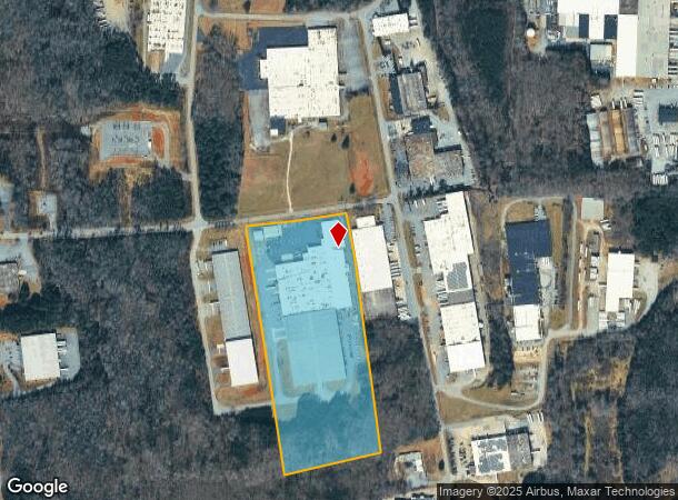
1405 Deborah Herman Rd Sw, Conover, NC 28613
NEARBY LISTINGS FOR SALE OR LEASE
Property Detail
1405 Deborah Herman Rd Sw
Hickory-Lenoir-Morganton, NC
Lfi Wind Down Inc
3732172115740000
LOT 2 PLAT 75-69
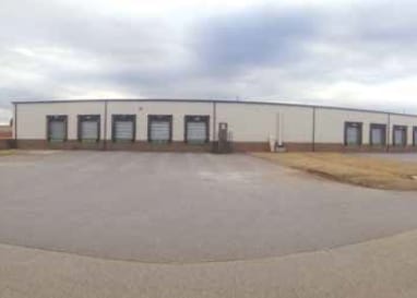
Warehouse
Catawba
X
North Carolina
3710373200J
2
2024
18.64 AC
2025
Catawba County
010204
Charlotte
152,385 SF
DEMOGRAPHICS near 1405 Deborah Herman Rd Sw
1 Mile
3 Mile
5 Mile
2024 Total Population
779
18,638
59,612
2029 Population
828
19,455
62,278
Pop Growth 2024-2029
+ 6.29%
+ 4.38%
+ 4.47%
Average Age
38
40
40
2024 Total Households
281
7,437
24,120
HH Growth 2024-2029
+ 6.05%
+ 4.26%
+ 4.42%
Median Household Inc
$62,979
$52,245
$53,107
Avg Household Size
2.70
2.40
2.40
2024 Avg HH Vehicles
2.00
2.00
2.00
Median Home Value
$177,847
$172,313
$166,508
Median Year Built
1987
1984
1982
Nearby Places
Map Layers
Map Styles
 Street
 Aerial
- Restaurants
- Banks
- Shops
- Fitness
- Groceries
Nearby Properties
Address
Land Use
TOTAL SIZE
Lot Size
Zoning
Address
Land Use
TOTAL SIZE
Lot Size
Zoning
83,982 SF
96.78 AC
OI
Address
Land Use
TOTAL SIZE
Lot Size
Zoning
502,665 SF
53.28 AC
EM-1-CD
Address
Land Use
TOTAL SIZE
Lot Size
Zoning
57.59 AC
OI
Address
Land Use
TOTAL SIZE
Lot Size
Zoning
219,033 SF
32.95 AC
IND-CZ
Address
Land Use
TOTAL SIZE
Lot Size
Zoning
31,111 SF
8.79 AC
PD
Address
Land Use
TOTAL SIZE
Lot Size
Zoning
14,140 SF
15.26 AC
PD
Address
Land Use
TOTAL SIZE
Lot Size
Zoning
7,164 SF
45.82 AC
OI
Address
Land Use
TOTAL SIZE
Lot Size
Zoning
94,152 SF
14.46 AC
IND
Address
Land Use
TOTAL SIZE
Lot Size
Zoning
326,813 SF
37.87 AC
IND
Address
Land Use
TOTAL SIZE
Lot Size
Zoning
353,092 SF
35.72 AC
IND
Address
Land Use
TOTAL SIZE
Lot Size
Zoning
7,684 SF
11.85 AC
R-20-CD
Address
Land Use
TOTAL SIZE
Lot Size
Zoning
300,990 SF
30.42 AC
IND-CZ
Address
Land Use
TOTAL SIZE
Lot Size
Zoning
217,586 SF
28.33 AC
CC-CD
Address
Land Use
TOTAL SIZE
Lot Size
Zoning
123,778 SF
19.99 AC
C-3
Address
Land Use
TOTAL SIZE
Lot Size
Zoning
248,173 SF
53.73 AC
B-4
Address
Land Use
TOTAL SIZE
Lot Size
Zoning
201,590 SF
20.31 AC
C-3
Address
Land Use
TOTAL SIZE
Lot Size
Zoning
31,778 SF
2.53 AC
OI
Address
Land Use
TOTAL SIZE
Lot Size
Zoning
30.63 AC
R-20
Address
Land Use
TOTAL SIZE
Lot Size
Zoning
4,700 SF
34.87 AC
COI
Address
Land Use
TOTAL SIZE
Lot Size
Zoning
103,090 SF
36.13 AC
R-9
Address
Land Use
TOTAL SIZE
Lot Size
Zoning
150,498 SF
11.27 AC
M-1
Address
Land Use
TOTAL SIZE
Lot Size
Zoning
9,064 SF
4.59 AC
B-2-CD
Address
Land Use
TOTAL SIZE
Lot Size
Zoning
8.96 AC
OI
Address
Land Use
TOTAL SIZE
Lot Size
Zoning
135,364 SF
16.32 AC
C-3
Address
Land Use
TOTAL SIZE
Lot Size
Zoning
146,737 SF
16.70 AC
IND-CZ
Address
Land Use
TOTAL SIZE
Lot Size
Zoning
121,170 SF
22.34 AC
IND-CZ
Address
Land Use
TOTAL SIZE
Lot Size
Zoning
99,684 SF
19.22 AC
OI
Address
Land Use
TOTAL SIZE
Lot Size
Zoning
146,574 SF
17.69 AC
C-3
Address
Land Use
TOTAL SIZE
Lot Size
Zoning
4,404 SF
12.31 AC
R-4
Address
Land Use
TOTAL SIZE
Lot Size
Zoning
67,085 SF
15.80 AC
PD-SC-M
The World's #1 Commercial Real Estate Marketplace
Connect with us
© 2025 CoStar Group
The information above has been obtained from sources believed reliable. While we do not doubt its accuracy we have not verified it and make no guarantee, warranty or representation about it. It is your responsibility to independently confirm its accuracy and completeness. Any projections, opinions, assumptions, or estimates used are for example only and do not represent the current or future performance of the property. The value of this transaction to you depends on tax and other factors which should be evaluated by your tax, financial, and legal advisors. You and your advisors should conduct a careful, independent investigation of the property to determine to your satisfaction the suitability of the property for your needs.