Property Record
1405 Dennison Cir, Carlisle, PA 17015
NEARBY LISTINGS FOR SALE OR LEASE
Property Detail
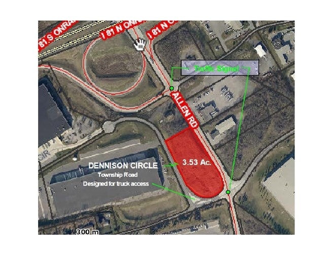
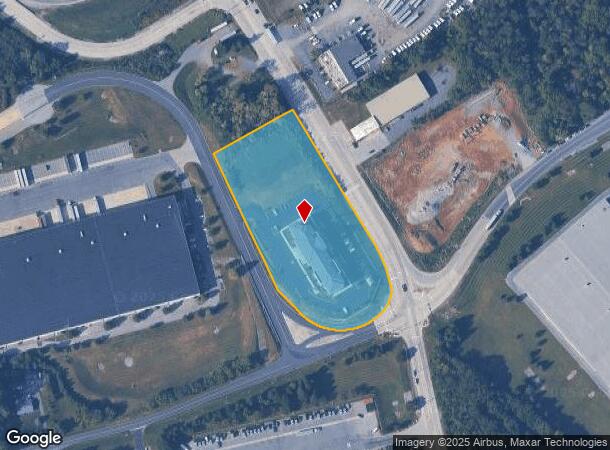
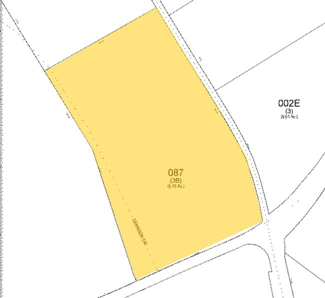
1405 Dennison Cir
40-09-0527-087
PL#202010667
Hotelormotel
Cumberland
X
Pennsylvania
42041C0240F
3.50 AC
2025
Harrisburg Area West
2025
Philadelphia
012501
Harrisburg-Carlisle, PA
DEMOGRAPHICS near 1405 Dennison Cir
1 Mile
3 Mile
5 Mile
2024 Total Population
377
22,356
49,723
2029 Population
392
23,941
53,127
Pop Growth 2024-2029
+ 3.98%
+ 7.09%
+ 6.85%
Average Age
51
41
41
2024 Total Households
177
8,989
20,003
HH Growth 2024-2029
+ 3.95%
+ 7.00%
+ 6.96%
Median Household Inc
$77,885
$69,167
$74,226
Avg Household Size
2.00
2.10
2.30
2024 Avg HH Vehicles
2.00
2.00
2.00
Median Home Value
$251,111
$243,090
$222,907
Median Year Built
1990
1969
1971
Nearby Places
Map Layers
Map Styles
 Street
 Aerial
- Restaurants
- Banks
- Shops
- Fitness
- Groceries
PUBLIC TRANSPORTATION
AIRPORT
Harrisburg International
DRIVE
WALK
Distance
Harrisburg International
49 min
34.5 mi
Hagerstown Regional/Richard A Henson Field
DRIVE
WALK
Distance
Hagerstown Regional/Richard A Henson Field
59 min
47.5 mi
SALE & LEASE HISTORY
LISTING DATE
SALE/LEASE

Jul 24, 2017
For Lease
Jan 09, 2017
For Sale
Feb 08, 2018
For Lease
Nearby Properties
Address
Land Use
TOTAL SIZE
Lot Size
Zoning
Address
Land Use
TOTAL SIZE
Lot Size
Zoning
Address
Land Use
TOTAL SIZE
Lot Size
Zoning
85.35 AC
Address
Land Use
TOTAL SIZE
Lot Size
Zoning
103.91 AC
Address
Land Use
TOTAL SIZE
Lot Size
Zoning
104.05 AC
Address
Land Use
TOTAL SIZE
Lot Size
Zoning
13.47 AC
Address
Land Use
TOTAL SIZE
Lot Size
Zoning
Address
Land Use
TOTAL SIZE
Lot Size
Zoning
34.64 AC
Address
Land Use
TOTAL SIZE
Lot Size
Zoning
Address
Land Use
TOTAL SIZE
Lot Size
Zoning
61.67 AC
Address
Land Use
TOTAL SIZE
Lot Size
Zoning
75.75 AC
Address
Land Use
TOTAL SIZE
Lot Size
Zoning
68.59 AC
Address
Land Use
TOTAL SIZE
Lot Size
Zoning
73.72 AC
Address
Land Use
TOTAL SIZE
Lot Size
Zoning
49.12 AC
Address
Land Use
TOTAL SIZE
Lot Size
Zoning
69.54 AC
Address
Land Use
TOTAL SIZE
Lot Size
Zoning
54.41 AC
Address
Land Use
TOTAL SIZE
Lot Size
Zoning
42.01 AC
Address
Land Use
TOTAL SIZE
Lot Size
Zoning
50.39 AC
Address
Land Use
TOTAL SIZE
Lot Size
Zoning
51.73 AC
Address
Land Use
TOTAL SIZE
Lot Size
Zoning
1.75 AC
Address
Land Use
TOTAL SIZE
Lot Size
Zoning
38.95 AC
Address
Land Use
TOTAL SIZE
Lot Size
Zoning
0.55 AC
Address
Land Use
TOTAL SIZE
Lot Size
Zoning
32.83 AC
Address
Land Use
TOTAL SIZE
Lot Size
Zoning
45.20 AC
Address
Land Use
TOTAL SIZE
Lot Size
Zoning
7.81 AC
Address
Land Use
TOTAL SIZE
Lot Size
Zoning
41.39 AC
Address
Land Use
TOTAL SIZE
Lot Size
Zoning
53.17 AC
Address
Land Use
TOTAL SIZE
Lot Size
Zoning
31.85 AC
Address
Land Use
TOTAL SIZE
Lot Size
Zoning
31.47 AC
Address
Land Use
TOTAL SIZE
Lot Size
Zoning
36.48 AC
Address
Land Use
TOTAL SIZE
Lot Size
Zoning
6.86 AC
The World's #1 Commercial Real Estate Marketplace
Connect with us
© 2026 CoStar Group
The information above has been obtained from sources believed reliable. While we do not doubt its accuracy we have not verified it and make no guarantee, warranty or representation about it. It is your responsibility to independently confirm its accuracy and completeness. Any projections, opinions, assumptions, or estimates used are for example only and do not represent the current or future performance of the property. The value of this transaction to you depends on tax and other factors which should be evaluated by your tax, financial, and legal advisors. You and your advisors should conduct a careful, independent investigation of the property to determine to your satisfaction the suitability of the property for your needs.