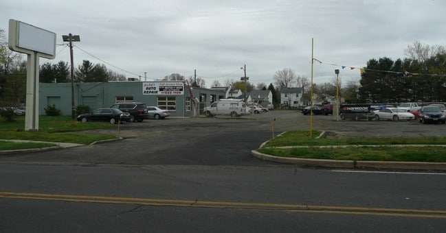
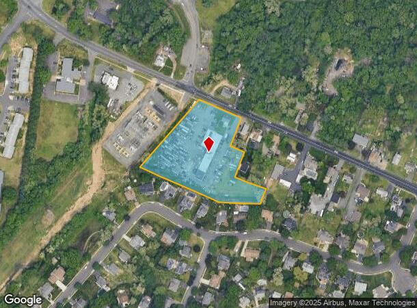
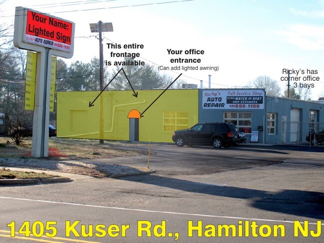
Property Record
1405 Kuser Rd, Trenton, NJ 08619

NEARBY LISTINGS FOR SALE OR LEASE
Property Detail
1405 Kuser Rd
03-02156-0000-00005
11532-
Vacantlandnec
Mercer
X
New Jersey
34021C0229F
5
2024
3.06 AC
2025
Trenton/295
002702
Northern New Jersey
982 SF
Trenton, NJ
DEMOGRAPHICS near 1405 Kuser Rd
1 Mile
3 Mile
5 Mile
2024 Total Population
10,820
124,130
231,366
2029 Population
10,744
121,775
228,727
Pop Growth 2024-2029
(0.70%)
(1.90%)
(1.14%)
Average Age
43
39
40
2024 Total Households
4,680
44,547
85,145
HH Growth 2024-2029
(0.94%)
(1.96%)
(1.19%)
Median Household Inc
$81,127
$72,126
$72,505
Avg Household Size
2.30
2.70
2.60
2024 Avg HH Vehicles
2.00
2.00
2.00
Median Home Value
$257,168
$237,954
$253,783
Median Year Built
1969
1956
1957
Nearby Places
Map Layers
Map Styles
 Street
 Aerial
- Restaurants
- Banks
- Shops
- Fitness
- Groceries
PUBLIC TRANSPORTATION
COMMUTER RAIL
Trenton Transit Center (Njt) (Northeast Corridor Line - NJ Transit Commuter Rail (NJ Transit), R7 - NJ Transit Commuter Rail (NJ Transit), River LINE - NJ Transit Commuter Rail (NJ Transit))
DRIVE
WALK
Distance
Trenton Transit Center (Njt) (Northeast Corridor Line - NJ Transit Commuter Rail (NJ Transit), R7 - NJ Transit Commuter Rail (NJ Transit), River LINE - NJ Transit Commuter Rail (NJ Transit))
9 min
3.5 mi
Trenton Transit Center (Trenton Line - SEPTA)
DRIVE
WALK
Distance
Trenton Transit Center (Trenton Line - SEPTA)
7 min
3.6 mi
AIRPORT
Trenton Mercer
DRIVE
WALK
Distance
Trenton Mercer
19 min
9.2 mi
Freight Ports
Port of Philadelphia
DRIVE
WALK
Distance
Port of Philadelphia
47 min
35.1 mi
SALE & LEASE HISTORY
LISTING DATE
SALE/LEASE

Mar 18, 2019
For Lease
Nearby Properties
Address
Land Use
TOTAL SIZE
Lot Size
Zoning
Address
Land Use
TOTAL SIZE
Lot Size
Zoning
13.73 AC
Address
Land Use
TOTAL SIZE
Lot Size
Zoning
Address
Land Use
TOTAL SIZE
Lot Size
Zoning
23.13 AC
RD
Address
Land Use
TOTAL SIZE
Lot Size
Zoning
35.83 AC
RB
Address
Land Use
TOTAL SIZE
Lot Size
Zoning
30.94 AC
Address
Land Use
TOTAL SIZE
Lot Size
Zoning
60.26 AC
RD
Address
Land Use
TOTAL SIZE
Lot Size
Zoning
44.82 AC
RD
Address
Land Use
TOTAL SIZE
Lot Size
Zoning
2,030 SF
45.57 AC
Address
Land Use
TOTAL SIZE
Lot Size
Zoning
Address
Land Use
TOTAL SIZE
Lot Size
Zoning
18.33 AC
Address
Land Use
TOTAL SIZE
Lot Size
Zoning
17.84 AC
HC
Address
Land Use
TOTAL SIZE
Lot Size
Zoning
4.07 AC
MU
Address
Land Use
TOTAL SIZE
Lot Size
Zoning
1,836 SF
33.91 AC
RD
Address
Land Use
TOTAL SIZE
Lot Size
Zoning
9.63 AC
RD
Address
Land Use
TOTAL SIZE
Lot Size
Zoning
23.53 AC
AT
Address
Land Use
TOTAL SIZE
Lot Size
Zoning
112,840 SF
Address
Land Use
TOTAL SIZE
Lot Size
Zoning
27.50 AC
R7
Address
Land Use
TOTAL SIZE
Lot Size
Zoning
Address
Land Use
TOTAL SIZE
Lot Size
Zoning
6.79 AC
R7
Address
Land Use
TOTAL SIZE
Lot Size
Zoning
15.80 AC
C
Address
Land Use
TOTAL SIZE
Lot Size
Zoning
157,952 SF
0.80 AC
BB
Address
Land Use
TOTAL SIZE
Lot Size
Zoning
173,385 SF
1.78 AC
MU
Address
Land Use
TOTAL SIZE
Lot Size
Zoning
21.62 AC
RD
Address
Land Use
TOTAL SIZE
Lot Size
Zoning
Address
Land Use
TOTAL SIZE
Lot Size
Zoning
156,128 SF
6.33 AC
RB
Address
Land Use
TOTAL SIZE
Lot Size
Zoning
Address
Land Use
TOTAL SIZE
Lot Size
Zoning
17,500 SF
18.14 AC
HC
Address
Land Use
TOTAL SIZE
Lot Size
Zoning
9.31 AC
HC
Address
Land Use
TOTAL SIZE
Lot Size
Zoning
456,860 SF
2.46 AC
BB
Address
Land Use
TOTAL SIZE
Lot Size
Zoning
16.62 AC
The World's #1 Commercial Real Estate Marketplace
Connect with us
© 2025 CoStar Group
The information above has been obtained from sources believed reliable. While we do not doubt its accuracy we have not verified it and make no guarantee, warranty or representation about it. It is your responsibility to independently confirm its accuracy and completeness. Any projections, opinions, assumptions, or estimates used are for example only and do not represent the current or future performance of the property. The value of this transaction to you depends on tax and other factors which should be evaluated by your tax, financial, and legal advisors. You and your advisors should conduct a careful, independent investigation of the property to determine to your satisfaction the suitability of the property for your needs.