Property Record
1405 Lamb Rd, Woodstock, IL 60098
NEARBY LISTINGS FOR SALE OR LEASE
-
-
View all Woodstock listings for lease on LoopNet.com
Property Detail
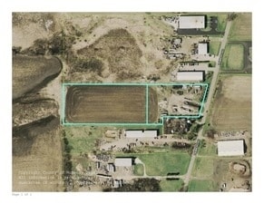
1405 Lamb Rd
Chicago-Naperville-Elgin, IL-IN-WI
DOC 2021R0064427 PT N1/2 GOV LT 2 LYING W OF CEN LAMB RD
08-30-300-023
McHenry
Industrialgeneral
Illinois
X
2
17111C0176J
2.97 AC
2024
Far Northwest
2024
Chicago
870404
DEMOGRAPHICS near 1405 Lamb Rd
1 Mile
3 Mile
5 Mile
2024 Total Population
33
18,148
29,778
2029 Population
33
18,114
29,789
Pop Growth 2024-2029
0.00%
(0.19%)
+ 0.04%
Average Age
45
41
41
2024 Total Households
12
6,826
11,282
HH Growth 2024-2029
0.00%
(0.22%)
+ 0.01%
Median Household Inc
$93,749
$74,372
$77,317
Avg Household Size
2.50
2.50
2.50
2024 Avg HH Vehicles
2.00
2.00
2.00
Median Home Value
$312,500
$187,235
$216,422
Median Year Built
1991
1974
1982
Nearby Places
Map Layers
Map Styles
 Street
 Aerial
- Restaurants
- Banks
- Shops
- Fitness
- Groceries
PUBLIC TRANSPORTATION
COMMUTER RAIL
Woodstock Station (Union Pacific Northwest Line - Northeast Illinois Regional Commuter Railroad (Metra))
DRIVE
WALK
Distance
Woodstock Station (Union Pacific Northwest Line - Northeast Illinois Regional Commuter Railroad (Metra))
7 min
2.7 mi
Freight Ports
Port Milwaukee
DRIVE
WALK
Distance
Port Milwaukee
93 min
66.6 mi
SALE & LEASE HISTORY
LISTING DATE
SALE/LEASE

Sep 24, 2016
For Sale
Oct 02, 2017
For Sale
Feb 23, 2017
For Sale
Aug 10, 2018
For Lease
Nearby Properties
Address
Land Use
TOTAL SIZE
Lot Size
Zoning
Address
Land Use
TOTAL SIZE
Lot Size
Zoning
64,528 SF
9.51 AC
Address
Land Use
TOTAL SIZE
Lot Size
Zoning
96,633 SF
3.97 AC
Address
Land Use
TOTAL SIZE
Lot Size
Zoning
164,167 SF
16.11 AC
Address
Land Use
TOTAL SIZE
Lot Size
Zoning
45,876 SF
5.02 AC
Address
Land Use
TOTAL SIZE
Lot Size
Zoning
12,699 SF
8 AC
Address
Land Use
TOTAL SIZE
Lot Size
Zoning
2.78 AC
Address
Land Use
TOTAL SIZE
Lot Size
Zoning
24,968 SF
0.50 AC
Address
Land Use
TOTAL SIZE
Lot Size
Zoning
32,754 SF
0.11 AC
Address
Land Use
TOTAL SIZE
Lot Size
Zoning
Address
Land Use
TOTAL SIZE
Lot Size
Zoning
Address
Land Use
TOTAL SIZE
Lot Size
Zoning
22,724 SF
3.63 AC
Address
Land Use
TOTAL SIZE
Lot Size
Zoning
24,164 SF
4.99 AC
Address
Land Use
TOTAL SIZE
Lot Size
Zoning
25,650 SF
0.19 AC
Address
Land Use
TOTAL SIZE
Lot Size
Zoning
139,352 SF
29.32 AC
Address
Land Use
TOTAL SIZE
Lot Size
Zoning
Address
Land Use
TOTAL SIZE
Lot Size
Zoning
35,389 SF
4.44 AC
Address
Land Use
TOTAL SIZE
Lot Size
Zoning
Address
Land Use
TOTAL SIZE
Lot Size
Zoning
7,740 SF
1.12 AC
Address
Land Use
TOTAL SIZE
Lot Size
Zoning
39,860 SF
2.10 AC
Address
Land Use
TOTAL SIZE
Lot Size
Zoning
15,000 SF
2.28 AC
Address
Land Use
TOTAL SIZE
Lot Size
Zoning
Address
Land Use
TOTAL SIZE
Lot Size
Zoning
4,978 SF
1.39 AC
Address
Land Use
TOTAL SIZE
Lot Size
Zoning
9,785 SF
2.58 AC
Address
Land Use
TOTAL SIZE
Lot Size
Zoning
78,482 SF
3.63 AC
Address
Land Use
TOTAL SIZE
Lot Size
Zoning
4,038 SF
0.85 AC
Address
Land Use
TOTAL SIZE
Lot Size
Zoning
13,500 SF
1.05 AC
Address
Land Use
TOTAL SIZE
Lot Size
Zoning
Address
Land Use
TOTAL SIZE
Lot Size
Zoning
27,360 SF
3.62 AC
Address
Land Use
TOTAL SIZE
Lot Size
Zoning
24,255 SF
0.25 AC
Address
Land Use
TOTAL SIZE
Lot Size
Zoning
The World's #1 Commercial Real Estate Marketplace
Connect with us
© 2025 CoStar Group
The information above has been obtained from sources believed reliable. While we do not doubt its accuracy we have not verified it and make no guarantee, warranty or representation about it. It is your responsibility to independently confirm its accuracy and completeness. Any projections, opinions, assumptions, or estimates used are for example only and do not represent the current or future performance of the property. The value of this transaction to you depends on tax and other factors which should be evaluated by your tax, financial, and legal advisors. You and your advisors should conduct a careful, independent investigation of the property to determine to your satisfaction the suitability of the property for your needs.