Property Record
1405 Sw Cook Rd, Port Orchard, WA 98367
NEARBY LISTINGS FOR SALE OR LEASE
Property Detail
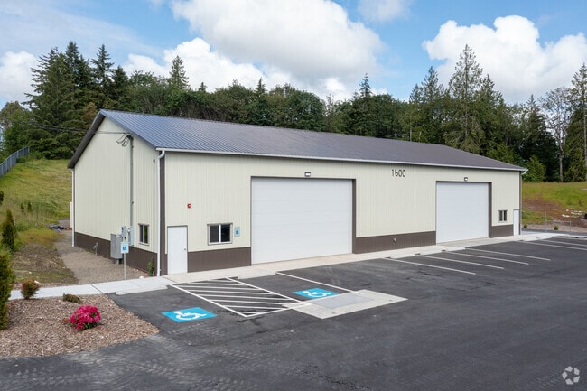
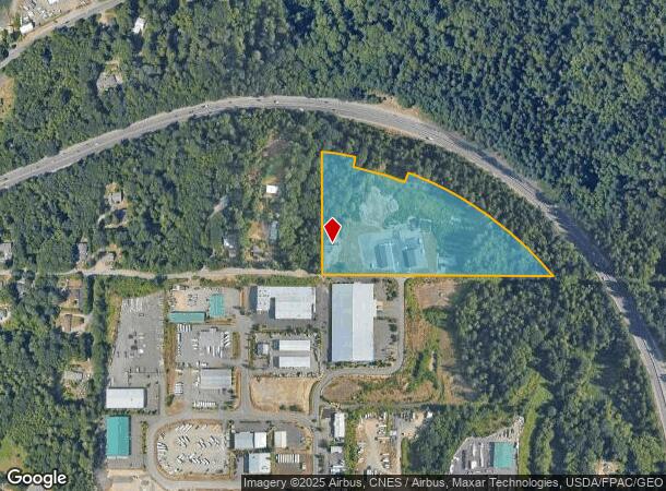
1405 Sw Cook Rd
342401-2-024-2005
THAT PORTION OF THE SOUTHEAST QUARTER OF THE NORTHWEST QUARTER, SECTION 34, TOWNSHIP 24 NORTH, RANGE 1 EAST, W.M., LYING SOUTHWESTERLY OF STATE HIGHWAY; SITUATE IN KITSAP COUNTY, WASHINGTON.
Commercialnec
Kitsap
X
Washington
53035C0368F
24
2025
9.80 AC
2026
South Kitsap County
092902
Bremerton/Silverdale
1,768 SF
Bremerton-Silverdale, WA
DEMOGRAPHICS near 1405 Sw Cook Rd
1 Mile
3 Mile
5 Mile
2024 Total Population
2,358
45,255
97,942
2029 Population
2,399
46,271
99,500
Pop Growth 2024-2029
+ 1.74%
+ 2.25%
+ 1.59%
Average Age
37
39
39
2024 Total Households
902
16,709
37,236
HH Growth 2024-2029
+ 1.77%
+ 2.52%
+ 1.76%
Median Household Inc
$77,557
$69,127
$69,695
Avg Household Size
2.50
2.50
2.40
2024 Avg HH Vehicles
2.00
2.00
2.00
Median Home Value
$360,256
$373,134
$404,015
Median Year Built
1984
1986
1979
Nearby Places
Map Layers
Map Styles
 Street
 Aerial
- Restaurants
- Banks
- Shops
- Fitness
- Groceries
PUBLIC TRANSPORTATION
AIRPORT
Seattle-Tacoma International
DRIVE
WALK
Distance
Seattle-Tacoma International
70 min
48.9 mi
Freight Ports
Port of Seattle
DRIVE
WALK
Distance
Port of Seattle
80 min
59.2 mi
SALE & LEASE HISTORY
LISTING DATE
SALE/LEASE

Nov 12, 2022
For Lease
Nov 09, 2022
For Lease
Dec 15, 2020
For Lease
Nearby Properties
Address
Land Use
TOTAL SIZE
Lot Size
Zoning
Address
Land Use
TOTAL SIZE
Lot Size
Zoning
552 SF
17.39 AC
CITY
Address
Land Use
TOTAL SIZE
Lot Size
Zoning
21,408 SF
8.26 AC
BVSAP
Address
Land Use
TOTAL SIZE
Lot Size
Zoning
143,022 SF
11.24 AC
R4
Address
Land Use
TOTAL SIZE
Lot Size
Zoning
127,853 SF
7.41 AC
R4
Address
Land Use
TOTAL SIZE
Lot Size
Zoning
135,371 SF
6.04 AC
R4
Address
Land Use
TOTAL SIZE
Lot Size
Zoning
112,847 SF
6.80 AC
UM
Address
Land Use
TOTAL SIZE
Lot Size
Zoning
17,592 SF
11.61 AC
UM
Address
Land Use
TOTAL SIZE
Lot Size
Zoning
25,973 SF
8.20 AC
CC
Address
Land Use
TOTAL SIZE
Lot Size
Zoning
110,994 SF
5.35 AC
R4
Address
Land Use
TOTAL SIZE
Lot Size
Zoning
1,092 SF
5.70 AC
CC
Address
Land Use
TOTAL SIZE
Lot Size
Zoning
125,582 SF
4.02 AC
NC
Address
Land Use
TOTAL SIZE
Lot Size
Zoning
110,778 SF
9.24 AC
CC
Address
Land Use
TOTAL SIZE
Lot Size
Zoning
Address
Land Use
TOTAL SIZE
Lot Size
Zoning
158,870 SF
14.62 AC
CC
Address
Land Use
TOTAL SIZE
Lot Size
Zoning
185,893 SF
17.89 AC
CC
Address
Land Use
TOTAL SIZE
Lot Size
Zoning
14,660 SF
6.14 AC
UM
Address
Land Use
TOTAL SIZE
Lot Size
Zoning
14,660 SF
6.07 AC
UM
Address
Land Use
TOTAL SIZE
Lot Size
Zoning
68,079 SF
2.16 AC
BVSAP
Address
Land Use
TOTAL SIZE
Lot Size
Zoning
62,642 SF
4.91 AC
UM
Address
Land Use
TOTAL SIZE
Lot Size
Zoning
73,931 SF
11.72 AC
FC
Address
Land Use
TOTAL SIZE
Lot Size
Zoning
43,944 SF
2.64 AC
FC
Address
Land Use
TOTAL SIZE
Lot Size
Zoning
45,379 SF
6.74 AC
UM
Address
Land Use
TOTAL SIZE
Lot Size
Zoning
2.33 AC
CITY
Address
Land Use
TOTAL SIZE
Lot Size
Zoning
75,225 SF
3.30 AC
R-10
Address
Land Use
TOTAL SIZE
Lot Size
Zoning
55,866 SF
8.48 AC
FC
Address
Land Use
TOTAL SIZE
Lot Size
Zoning
138,087 SF
14.24 AC
CC
Address
Land Use
TOTAL SIZE
Lot Size
Zoning
68,708 SF
7.89 AC
PF
Address
Land Use
TOTAL SIZE
Lot Size
Zoning
520 SF
7.79 AC
C
Address
Land Use
TOTAL SIZE
Lot Size
Zoning
42,665 SF
5.55 AC
FC
Address
Land Use
TOTAL SIZE
Lot Size
Zoning
39,800 SF
4.69 AC
CC
The World's #1 Commercial Real Estate Marketplace
Connect with us
© 2025 CoStar Group
The information above has been obtained from sources believed reliable. While we do not doubt its accuracy we have not verified it and make no guarantee, warranty or representation about it. It is your responsibility to independently confirm its accuracy and completeness. Any projections, opinions, assumptions, or estimates used are for example only and do not represent the current or future performance of the property. The value of this transaction to you depends on tax and other factors which should be evaluated by your tax, financial, and legal advisors. You and your advisors should conduct a careful, independent investigation of the property to determine to your satisfaction the suitability of the property for your needs.