Property Record
1405 W Broad St, Saint Pauls, NC 28384


NEARBY LISTINGS FOR SALE OR LEASE
Property Detail
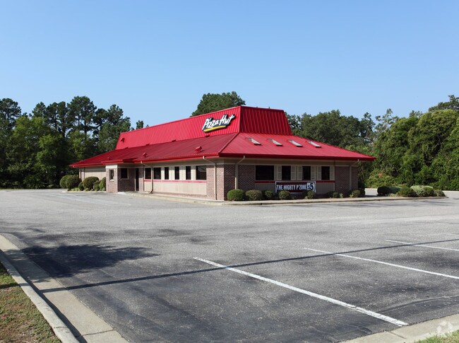
1405 W Broad St
Restaurantdrivein
Survey For Nora D Clark
X
131218316109 BROAD STREET
3720130200J
Bladen
2025
North Carolina
2025
1.20 AC
960102
Other Market Areas
4,427 SF
131218316109
DEMOGRAPHICS near 1405 W Broad St
1 Mile
3 Mile
5 Mile
2024 Total Population
1,362
4,544
6,208
2029 Population
1,351
4,492
6,142
Pop Growth 2024-2029
(0.81%)
(1.14%)
(1.06%)
Average Age
43
43
43
2024 Total Households
575
1,921
2,592
HH Growth 2024-2029
(0.70%)
(1.09%)
(1.04%)
Median Household Inc
$27,613
$24,038
$29,514
Avg Household Size
2.30
2.20
2.30
2024 Avg HH Vehicles
2.00
2.00
2.00
Median Home Value
$167,977
$171,455
$172,702
Median Year Built
1969
1976
1979
Nearby Places
Map Layers
Map Styles
 Street
 Aerial
- Restaurants
- Banks
- Shops
- Fitness
- Groceries
PUBLIC TRANSPORTATION
AIRPORT
Fayetteville Regional/Grannis Field
DRIVE
WALK
Distance
Fayetteville Regional/Grannis Field
56 min
37.2 mi
Freight Ports
Port of Wilmington
DRIVE
WALK
Distance
Port of Wilmington
77 min
52.7 mi
Nearby Properties
Address
Land Use
TOTAL SIZE
Lot Size
Zoning
Address
Land Use
TOTAL SIZE
Lot Size
Zoning
170,001 SF
58.60 AC
Address
Land Use
TOTAL SIZE
Lot Size
Zoning
70,401 SF
9.56 AC
Address
Land Use
TOTAL SIZE
Lot Size
Zoning
32,968 SF
3.58 AC
Address
Land Use
TOTAL SIZE
Lot Size
Zoning
57,966 SF
48.40 AC
Address
Land Use
TOTAL SIZE
Lot Size
Zoning
68,097 SF
1.60 AC
Address
Land Use
TOTAL SIZE
Lot Size
Zoning
164,976 SF
81.06 AC
Address
Land Use
TOTAL SIZE
Lot Size
Zoning
44,153 SF
5.40 AC
Address
Land Use
TOTAL SIZE
Lot Size
Zoning
20,223 SF
2.90 AC
Address
Land Use
TOTAL SIZE
Lot Size
Zoning
50,454 SF
3.68 AC
Address
Land Use
TOTAL SIZE
Lot Size
Zoning
29,367 SF
4.90 AC
Address
Land Use
TOTAL SIZE
Lot Size
Zoning
24,272 SF
5.65 AC
Address
Land Use
TOTAL SIZE
Lot Size
Zoning
45,960 SF
4.61 AC
Address
Land Use
TOTAL SIZE
Lot Size
Zoning
41,600 SF
1.97 AC
Address
Land Use
TOTAL SIZE
Lot Size
Zoning
26,102 SF
2.23 AC
RA
Address
Land Use
TOTAL SIZE
Lot Size
Zoning
18,087 SF
2.29 AC
Address
Land Use
TOTAL SIZE
Lot Size
Zoning
21,344 SF
2.64 AC
Address
Land Use
TOTAL SIZE
Lot Size
Zoning
37,206 SF
5.58 AC
Address
Land Use
TOTAL SIZE
Lot Size
Zoning
23,326 SF
2.53 AC
Address
Land Use
TOTAL SIZE
Lot Size
Zoning
2,520 SF
10.67 AC
Address
Land Use
TOTAL SIZE
Lot Size
Zoning
8,192 SF
1.70 AC
Address
Land Use
TOTAL SIZE
Lot Size
Zoning
20,218 SF
4.90 AC
Address
Land Use
TOTAL SIZE
Lot Size
Zoning
14,400 SF
0.43 AC
Address
Land Use
TOTAL SIZE
Lot Size
Zoning
55,917 SF
3.20 AC
Address
Land Use
TOTAL SIZE
Lot Size
Zoning
6,981 SF
1.40 AC
Address
Land Use
TOTAL SIZE
Lot Size
Zoning
28,000 SF
10.83 AC
Address
Land Use
TOTAL SIZE
Lot Size
Zoning
9,726 SF
17 AC
Address
Land Use
TOTAL SIZE
Lot Size
Zoning
10,872 SF
3.66 AC
Address
Land Use
TOTAL SIZE
Lot Size
Zoning
18,744 SF
35.24 AC
Address
Land Use
TOTAL SIZE
Lot Size
Zoning
58,800 SF
5.82 AC
Address
Land Use
TOTAL SIZE
Lot Size
Zoning
8,120 SF
0.84 AC
The World's #1 Commercial Real Estate Marketplace
Connect with us
© 2025 CoStar Group
The information above has been obtained from sources believed reliable. While we do not doubt its accuracy we have not verified it and make no guarantee, warranty or representation about it. It is your responsibility to independently confirm its accuracy and completeness. Any projections, opinions, assumptions, or estimates used are for example only and do not represent the current or future performance of the property. The value of this transaction to you depends on tax and other factors which should be evaluated by your tax, financial, and legal advisors. You and your advisors should conduct a careful, independent investigation of the property to determine to your satisfaction the suitability of the property for your needs.