Property Record
14055 Cedar Rd, Cleveland, OH 44118

NEARBY LISTINGS FOR SALE OR LEASE
Property Detail
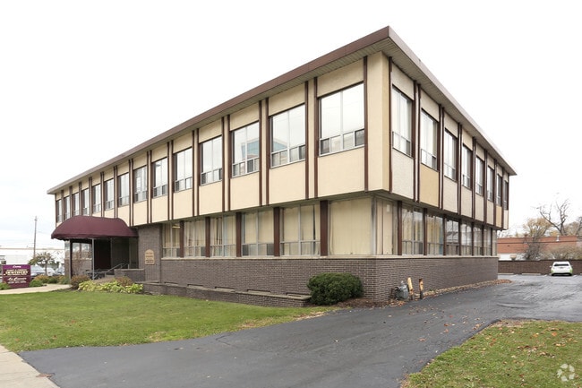
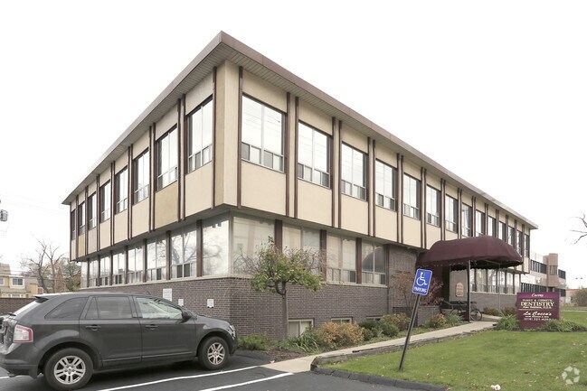
14055 Cedar Rd
704-19-026
Van Deboe-Hager Cos Cedar Cen
Medicalbuilding
70419026
X
Cuyahoga
39035C0093E
Ohio
0
1.33 AC
2024
East
185202
Cleveland
22,983 SF
Cleveland-Elyria, OH
DEMOGRAPHICS near 14055 Cedar Rd
1 Mile
3 Mile
5 Mile
2024 Total Population
20,190
121,994
315,878
2029 Population
19,657
119,004
311,042
Pop Growth 2024-2029
(2.64%)
(2.45%)
(1.53%)
Average Age
37
41
41
2024 Total Households
7,582
51,773
140,059
HH Growth 2024-2029
(2.84%)
(2.60%)
(1.60%)
Median Household Inc
$71,808
$74,218
$48,245
Avg Household Size
2.40
2.20
2.10
2024 Avg HH Vehicles
2.00
2.00
1.00
Median Home Value
$168,651
$186,744
$152,624
Median Year Built
1950
1951
1951
Nearby Places
Map Layers
Map Styles
 Street
 Aerial
- Restaurants
- Banks
- Shops
- Fitness
- Groceries
PUBLIC TRANSPORTATION
COMMUTER RAIL
Cleveland Lakefront Station (Blue Line - Greater Cleveland Regional Transit Authority Rapid Transit (The Rapid), Green Line - Greater Cleveland Regional Transit Authority Rapid Transit (The Rapid))
DRIVE
WALK
Distance
Cleveland Lakefront Station (Blue Line - Greater Cleveland Regional Transit Authority Rapid Transit (The Rapid), Green Line - Greater Cleveland Regional Transit Authority Rapid Transit (The Rapid))
26 min
9.8 mi
AIRPORT
Cleveland-Hopkins International
DRIVE
WALK
Distance
Cleveland-Hopkins International
37 min
20.8 mi
SALE & LEASE HISTORY
LISTING DATE
SALE/LEASE

Sep 25, 2016
For Lease
Nearby Properties
Address
Land Use
TOTAL SIZE
Lot Size
Zoning
Address
Land Use
TOTAL SIZE
Lot Size
Zoning
964,082 SF
40.67 AC
Address
Land Use
TOTAL SIZE
Lot Size
Zoning
1,066,853 SF
42.18 AC
U-5
Address
Land Use
TOTAL SIZE
Lot Size
Zoning
650,536 SF
19.01 AC
U-3A
Address
Land Use
TOTAL SIZE
Lot Size
Zoning
379,326 SF
43.45 AC
CRG
Address
Land Use
TOTAL SIZE
Lot Size
Zoning
475,904 SF
8.04 AC
U-7A
Address
Land Use
TOTAL SIZE
Lot Size
Zoning
229,833 SF
19.04 AC
U-3
Address
Land Use
TOTAL SIZE
Lot Size
Zoning
302,009 SF
6.62 AC
U-7A
Address
Land Use
TOTAL SIZE
Lot Size
Zoning
257,048 SF
17.93 AC
S1
Address
Land Use
TOTAL SIZE
Lot Size
Zoning
246,578 SF
28.60 AC
U-5
Address
Land Use
TOTAL SIZE
Lot Size
Zoning
421,649 SF
23.15 AC
U-5
Address
Land Use
TOTAL SIZE
Lot Size
Zoning
485,482 SF
9.60 AC
U-8A
Address
Land Use
TOTAL SIZE
Lot Size
Zoning
413,626 SF
21.95 AC
S2
Address
Land Use
TOTAL SIZE
Lot Size
Zoning
294,215 SF
4.70 AC
U-3A
Address
Land Use
TOTAL SIZE
Lot Size
Zoning
346,762 SF
4.57 AC
U-3A
Address
Land Use
TOTAL SIZE
Lot Size
Zoning
119,418 SF
42.99 AC
U-5
Address
Land Use
TOTAL SIZE
Lot Size
Zoning
91,540 SF
14.35 AC
CRG
Address
Land Use
TOTAL SIZE
Lot Size
Zoning
4,414 SF
112.92 AC
U-10
Address
Land Use
TOTAL SIZE
Lot Size
Zoning
297,799 SF
4.18 AC
U-3
Address
Land Use
TOTAL SIZE
Lot Size
Zoning
108,198 SF
25.45 AC
U-5
Address
Land Use
TOTAL SIZE
Lot Size
Zoning
189,444 SF
9.71 AC
U-5
Address
Land Use
TOTAL SIZE
Lot Size
Zoning
96,262 SF
10 AC
U-5
Address
Land Use
TOTAL SIZE
Lot Size
Zoning
18,898 SF
3.57 AC
U-3
Address
Land Use
TOTAL SIZE
Lot Size
Zoning
82,834 SF
21.10 AC
U-5
Address
Land Use
TOTAL SIZE
Lot Size
Zoning
59,308 SF
5.84 AC
U-1A-2
Address
Land Use
TOTAL SIZE
Lot Size
Zoning
131,846 SF
5.94 AC
U-9
Address
Land Use
TOTAL SIZE
Lot Size
Zoning
222,800 SF
2.32 AC
U-3
Address
Land Use
TOTAL SIZE
Lot Size
Zoning
100,469 SF
25.96 AC
AA
Address
Land Use
TOTAL SIZE
Lot Size
Zoning
249,712 SF
22.69 AC
I
Address
Land Use
TOTAL SIZE
Lot Size
Zoning
255,964 SF
39.41 AC
R-75
Address
Land Use
TOTAL SIZE
Lot Size
Zoning
110,000 SF
0.85 AC
The World's #1 Commercial Real Estate Marketplace
Connect with us
© 2025 CoStar Group
The information above has been obtained from sources believed reliable. While we do not doubt its accuracy we have not verified it and make no guarantee, warranty or representation about it. It is your responsibility to independently confirm its accuracy and completeness. Any projections, opinions, assumptions, or estimates used are for example only and do not represent the current or future performance of the property. The value of this transaction to you depends on tax and other factors which should be evaluated by your tax, financial, and legal advisors. You and your advisors should conduct a careful, independent investigation of the property to determine to your satisfaction the suitability of the property for your needs.