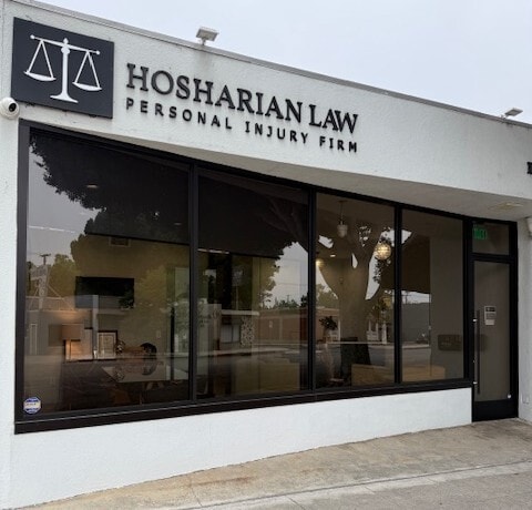
Property Record
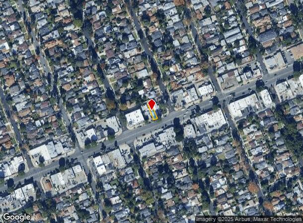
1407 W Magnolia Blvd, Burbank, CA 91506

Current Lease Availabilities
NEARBY LISTINGS FOR SALE OR LEASE
Property Detail
1407 W Magnolia Blvd
Los Angeles-Long Beach-Glendale, CA
9428
2449-025-013
TRACT # 9428 LOT 114
Loftbuilding
Los Angeles
X
California
06037C1337F
114
2024
0.06 AC
2025
Burbank
310900
Los Angeles
1,750 SF
DEMOGRAPHICS near 1407 W Magnolia Blvd
1 Mile
3 Mile
5 Mile
2024 Total Population
22,520
178,640
466,225
2029 Population
21,821
172,950
452,571
Pop Growth 2024-2029
(3.10%)
(3.19%)
(2.93%)
Average Age
42
41
41
2024 Total Households
8,908
72,697
190,497
HH Growth 2024-2029
(3.40%)
(3.39%)
(3.10%)
Median Household Inc
$89,413
$77,817
$76,659
Avg Household Size
2.50
2.40
2.40
2024 Avg HH Vehicles
2.00
2.00
2.00
Median Home Value
$853,627
$871,836
$918,174
Median Year Built
1952
1962
1964
Nearby Places
Map Layers
Map Styles
 Street
 Aerial
- Restaurants
- Banks
- Shops
- Fitness
- Groceries
PUBLIC TRANSPORTATION
COMMUTER RAIL
Downtown Burbank (Antelope Valley Line - Southern California Regional Rail Authority (Metrolink), Ventura County Line - Southern California Regional Rail Authority (Metrolink))
DRIVE
WALK
Distance
Downtown Burbank (Antelope Valley Line - Southern California Regional Rail Authority (Metrolink), Ventura County Line - Southern California Regional Rail Authority (Metrolink))
3 min
18 min
1.0 mi
Burbank-Bob Hope Airport (Ventura County Line - Southern California Regional Rail Authority (Metrolink))
DRIVE
WALK
Distance
Burbank-Bob Hope Airport (Ventura County Line - Southern California Regional Rail Authority (Metrolink))
7 min
3.0 mi
AIRPORT
Bob Hope
DRIVE
WALK
Distance
Bob Hope
11 min
5.0 mi
Los Angeles International
DRIVE
WALK
Distance
Los Angeles International
39 min
27.8 mi
Long Beach (Daugherty Field)
DRIVE
WALK
Distance
Long Beach (Daugherty Field)
46 min
34.0 mi
Freight Ports
Port of Long Beach
DRIVE
WALK
Distance
Port of Long Beach
49 min
35.9 mi
Nearby Properties
Address
Land Use
TOTAL SIZE
Lot Size
Zoning
Address
Land Use
TOTAL SIZE
Lot Size
Zoning
152,217 SF
70.95 AC
BUM1*
Address
Land Use
TOTAL SIZE
Lot Size
Zoning
735,900 SF
34.87 AC
BUPD*
Address
Land Use
TOTAL SIZE
Lot Size
Zoning
207,766 SF
42.81 AC
BUM1*
Address
Land Use
TOTAL SIZE
Lot Size
Zoning
12,827 SF
130.37 AC
LAM11/2*
Address
Land Use
TOTAL SIZE
Lot Size
Zoning
849,801 SF
59.25 AC
BUM2
Address
Land Use
TOTAL SIZE
Lot Size
Zoning
616,662 SF
19.66 AC
BUM1*
Address
Land Use
TOTAL SIZE
Lot Size
Zoning
986,983 SF
105.50 AC
LARE40
Address
Land Use
TOTAL SIZE
Lot Size
Zoning
359,197 SF
13.49 AC
GLENDALE M
Address
Land Use
TOTAL SIZE
Lot Size
Zoning
397,477 SF
2.75 AC
BUR4
Address
Land Use
TOTAL SIZE
Lot Size
Zoning
979,623 SF
13.36 AC
GLM2
Address
Land Use
TOTAL SIZE
Lot Size
Zoning
690,600 SF
6.57 AC
LACM
Address
Land Use
TOTAL SIZE
Lot Size
Zoning
475,433 SF
19.35 AC
BUM1*
Address
Land Use
TOTAL SIZE
Lot Size
Zoning
489,466 SF
2.90 AC
BUM1
Address
Land Use
TOTAL SIZE
Lot Size
Zoning
452,048 SF
21.58 AC
BCCM
Address
Land Use
TOTAL SIZE
Lot Size
Zoning
696,128 SF
2.42 AC
BUC3*
Address
Land Use
TOTAL SIZE
Lot Size
Zoning
43,558 SF
30.11 AC
BUMI-C2*
Address
Land Use
TOTAL SIZE
Lot Size
Zoning
1,328,547 SF
39.36 AC
BUPD
Address
Land Use
TOTAL SIZE
Lot Size
Zoning
432,232 SF
7.17 AC
BUM2
Address
Land Use
TOTAL SIZE
Lot Size
Zoning
219,607 SF
1.51 AC
BUR4
Address
Land Use
TOTAL SIZE
Lot Size
Zoning
380,017 SF
Address
Land Use
TOTAL SIZE
Lot Size
Zoning
440,774 SF
2.20 AC
BUR4*
Address
Land Use
TOTAL SIZE
Lot Size
Zoning
462,896 SF
1.38 AC
BUR4*
Address
Land Use
TOTAL SIZE
Lot Size
Zoning
362,863 SF
1.82 AC
BUMZ
Address
Land Use
TOTAL SIZE
Lot Size
Zoning
346,186 SF
11.72 AC
BUM2*
Address
Land Use
TOTAL SIZE
Lot Size
Zoning
232,965 SF
3.78 AC
LAC4
Address
Land Use
TOTAL SIZE
Lot Size
Zoning
558,532 SF
5.20 AC
BUC4*
Address
Land Use
TOTAL SIZE
Lot Size
Zoning
660,463 SF
6.88 AC
BUR4*
Address
Land Use
TOTAL SIZE
Lot Size
Zoning
612,976 SF
3.53 AC
BUC2*
Address
Land Use
TOTAL SIZE
Lot Size
Zoning
227,746 SF
4.03 AC
LAC4
Address
Land Use
TOTAL SIZE
Lot Size
Zoning
151,704 SF
1 AC
BUC4*
The World's #1 Commercial Real Estate Marketplace
Connect with us
© 2025 CoStar Group
The information above has been obtained from sources believed reliable. While we do not doubt its accuracy we have not verified it and make no guarantee, warranty or representation about it. It is your responsibility to independently confirm its accuracy and completeness. Any projections, opinions, assumptions, or estimates used are for example only and do not represent the current or future performance of the property. The value of this transaction to you depends on tax and other factors which should be evaluated by your tax, financial, and legal advisors. You and your advisors should conduct a careful, independent investigation of the property to determine to your satisfaction the suitability of the property for your needs.