Property Record
14073 S Us Highway 27, Dewitt, MI 48820
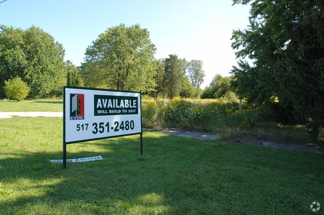
This Property Is For Sale
NEARBY LISTINGS FOR SALE OR LEASE
Property Detail
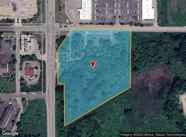
14073 S Us Highway 27
Lansing-East Lansing, MI
Pob Sub
050-022-200-005-00
BEG 1000 FT S OF NW COR OF SEC 22 T5NR2W TH S 320 FT E 1520 FT S 1320 FT E 800FT N 730 FT E 330 FT N 440 FT W 330 FT N 145 FT
Commercialacreage
Clinton
AE
Michigan
26065C0020D
11.20 AC
0
Outlying Clinton County
2025
West Michigan
010201
DEMOGRAPHICS near 14073 S Us Highway 27
1 Mile
3 Mile
5 Mile
2024 Total Population
3,140
18,135
66,592
2029 Population
3,254
18,636
67,254
Pop Growth 2024-2029
+ 3.63%
+ 2.76%
+ 0.99%
Average Age
41
42
39
2024 Total Households
1,204
7,286
28,161
HH Growth 2024-2029
+ 3.57%
+ 2.76%
+ 0.87%
Median Household Inc
$83,270
$78,162
$61,476
Avg Household Size
2.50
2.40
2.30
2024 Avg HH Vehicles
2.00
2.00
2.00
Median Home Value
$261,990
$238,636
$186,133
Median Year Built
1992
1984
1973
Nearby Places
Map Layers
Map Styles
 Street
 Aerial
- Restaurants
- Banks
- Shops
- Fitness
- Groceries
PUBLIC TRANSPORTATION
COMMUTER RAIL
East Lansing Amtrak Station (Blue Water - Amtrak)
DRIVE
WALK
Distance
East Lansing Amtrak Station (Blue Water - Amtrak)
13 min
9.1 mi
AIRPORT
Capital Region International
DRIVE
WALK
Distance
Capital Region International
13 min
6.2 mi
Freight Ports
Port of Toledo
DRIVE
WALK
Distance
Port of Toledo
152 min
120.2 mi
Nearby Properties
Address
Land Use
TOTAL SIZE
Lot Size
Zoning
Address
Land Use
TOTAL SIZE
Lot Size
Zoning
142,152 SF
47.56 AC
B4
Address
Land Use
TOTAL SIZE
Lot Size
Zoning
4,312 SF
30.47 AC
M3
Address
Land Use
TOTAL SIZE
Lot Size
Zoning
5,180 SF
16.94 AC
M2
Address
Land Use
TOTAL SIZE
Lot Size
Zoning
3,252 SF
10.16 AC
M3
Address
Land Use
TOTAL SIZE
Lot Size
Zoning
2,092 SF
152.25 AC
MHP
Address
Land Use
TOTAL SIZE
Lot Size
Zoning
4,976 SF
6.23 AC
MF-N
Address
Land Use
TOTAL SIZE
Lot Size
Zoning
8,270 SF
13.15 AC
M3
Address
Land Use
TOTAL SIZE
Lot Size
Zoning
20,000 SF
25.53 AC
BC
Address
Land Use
TOTAL SIZE
Lot Size
Zoning
4,590 SF
69.64 AC
MHP
Address
Land Use
TOTAL SIZE
Lot Size
Zoning
16,600 SF
19.22 AC
IL
Address
Land Use
TOTAL SIZE
Lot Size
Zoning
14,276 SF
6.42 AC
M3
Address
Land Use
TOTAL SIZE
Lot Size
Zoning
207,565 SF
11.50 AC
BC
Address
Land Use
TOTAL SIZE
Lot Size
Zoning
10,992 SF
10.43 AC
M3
Address
Land Use
TOTAL SIZE
Lot Size
Zoning
56,579 SF
8.48 AC
BSC
Address
Land Use
TOTAL SIZE
Lot Size
Zoning
4,464 SF
8.29 AC
MF
Address
Land Use
TOTAL SIZE
Lot Size
Zoning
86,211 SF
32.56 AC
BC
Address
Land Use
TOTAL SIZE
Lot Size
Zoning
58.89 AC
B4
Address
Land Use
TOTAL SIZE
Lot Size
Zoning
39,372 SF
5.86 AC
BSC
Address
Land Use
TOTAL SIZE
Lot Size
Zoning
19,000 SF
CB
Address
Land Use
TOTAL SIZE
Lot Size
Zoning
6,041 SF
A
Address
Land Use
TOTAL SIZE
Lot Size
Zoning
21,453 SF
3.10 AC
B4
Address
Land Use
TOTAL SIZE
Lot Size
Zoning
49,500 SF
4.38 AC
IL
Address
Land Use
TOTAL SIZE
Lot Size
Zoning
40.83 AC
IL
Address
Land Use
TOTAL SIZE
Lot Size
Zoning
15,000 SF
44.67 AC
A/BC
Address
Land Use
TOTAL SIZE
Lot Size
Zoning
1,868 SF
13.80 AC
MHP
Address
Land Use
TOTAL SIZE
Lot Size
Zoning
1,000 SF
236.70 AC
A
Address
Land Use
TOTAL SIZE
Lot Size
Zoning
15,576 SF
5.75 AC
M3
Address
Land Use
TOTAL SIZE
Lot Size
Zoning
17,490 SF
3.48 AC
BC
Address
Land Use
TOTAL SIZE
Lot Size
Zoning
22,413 SF
3.32 AC
M4
Address
Land Use
TOTAL SIZE
Lot Size
Zoning
5,536 SF
95.10 AC
PQ
The World's #1 Commercial Real Estate Marketplace
Connect with us
© 2025 CoStar Group
The information above has been obtained from sources believed reliable. While we do not doubt its accuracy we have not verified it and make no guarantee, warranty or representation about it. It is your responsibility to independently confirm its accuracy and completeness. Any projections, opinions, assumptions, or estimates used are for example only and do not represent the current or future performance of the property. The value of this transaction to you depends on tax and other factors which should be evaluated by your tax, financial, and legal advisors. You and your advisors should conduct a careful, independent investigation of the property to determine to your satisfaction the suitability of the property for your needs.