Property Record
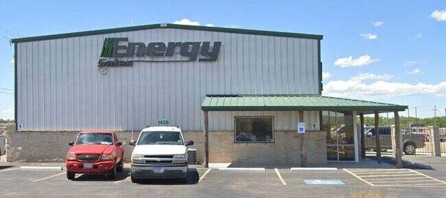
1408 W Interstate 20, Odessa, TX 79763


Property Detail
1408 W Interstate 20
36550-00270-00000
WINDCREST INDUSTRIAL BLOCK 4 LOT 3
Commercialnec
Ector
EB7
Texas
AE The base floodplain where base flood elevations are provided. AE Zones are now used on new format FIRMs instead of A1-A30 Zones.
3
2025
4.56 AC
2025
Midland & Odessa
002000
Other Market Areas
2,000 SF
Odessa, TX
NEARBY LISTINGS FOR SALE OR LEASE
DEMOGRAPHICS near 1408 W Interstate 20
1 mile
3 mile
5 mile
2025 Total Population
3,841
37,764
87,082
2030 Population
4,050
40,302
92,453
Pop Growth 2025-2030
+ 5.44%
+ 6.72%
+ 6.17%
Average Age
37
36
35
2025 Total Households
1,375
13,031
30,452
HH Growth 2025-2030
+ 6.40%
+ 7.85%
+ 7.32%
Median Household Inc
$48,204
$54,220
$63,710
Avg Household Size
2.80
2.80
2.70
2025 Avg HH Vehicles
2.00
2.00
2.00
Median Home Value
$64,455
$125,575
$157,273
Median Year Built
1971
1971
1970
Nearby Places
Map Layers
Map Styles
 Street
 Aerial
Layers
 Traffic
 Biking
Places
Listings with unknown addresses are not visible on the map
- Restaurants
- Banks
- Shops
- Fitness
- Groceries
PUBLIC TRANSPORTATION
AIRPORT
Midland International Air And Space Port
Drive
Walk
Distance
Midland International Air And Space Port
21 min
14.5 mi
Nearby Properties
Address
Land Use
TOTAL SIZE
Lot Size
Zoning
Address
Land Use
TOTAL SIZE
Lot Size
Zoning
170,241 SF
16.56 AC
EB6
Address
Land Use
TOTAL SIZE
Lot Size
Zoning
Address
Land Use
TOTAL SIZE
Lot Size
Zoning
159,239 SF
6.64 AC
EE1
Address
Land Use
TOTAL SIZE
Lot Size
Zoning
57,566 SF
Address
Land Use
TOTAL SIZE
Lot Size
Zoning
117,725 SF
19.23 AC
EE5
Address
Land Use
TOTAL SIZE
Lot Size
Zoning
30,600 SF
4.51 AC
EB6
Address
Land Use
TOTAL SIZE
Lot Size
Zoning
232,969 SF
19.81 AC
EB7
Address
Land Use
TOTAL SIZE
Lot Size
Zoning
22,470 SF
2.07 AC
EB6
Address
Land Use
TOTAL SIZE
Lot Size
Zoning
10,644 SF
57.53 AC
Address
Land Use
TOTAL SIZE
Lot Size
Zoning
111,278 SF
28.53 AC
EB6
Address
Land Use
TOTAL SIZE
Lot Size
Zoning
99,244 SF
4.66 AC
EE1
Address
Land Use
TOTAL SIZE
Lot Size
Zoning
214,832 SF
10.42 AC
EB5
Address
Land Use
TOTAL SIZE
Lot Size
Zoning
Address
Land Use
TOTAL SIZE
Lot Size
Zoning
68,377 SF
9.69 AC
ES2
Address
Land Use
TOTAL SIZE
Lot Size
Zoning
65,175 SF
4.68 AC
EE1
Address
Land Use
TOTAL SIZE
Lot Size
Zoning
36,648 SF
86.41 AC
ES1
Address
Land Use
TOTAL SIZE
Lot Size
Zoning
25,560 SF
1.52 AC
EB6
Address
Land Use
TOTAL SIZE
Lot Size
Zoning
11,600 SF
28.47 AC
ES1
Address
Land Use
TOTAL SIZE
Lot Size
Zoning
40,557 SF
2.12 AC
EE1
Address
Land Use
TOTAL SIZE
Lot Size
Zoning
112,000 SF
19.10 AC
ES2
Address
Land Use
TOTAL SIZE
Lot Size
Zoning
57,566 SF
3.94 AC
EE1
Address
Land Use
TOTAL SIZE
Lot Size
Zoning
4,836 SF
4.68 AC
EE1
Address
Land Use
TOTAL SIZE
Lot Size
Zoning
72,624 SF
2.28 AC
ES1
Address
Land Use
TOTAL SIZE
Lot Size
Zoning
78,447 SF
10.93 AC
EE1
Address
Land Use
TOTAL SIZE
Lot Size
Zoning
153,754 SF
9.57 AC
EE5
Address
Land Use
TOTAL SIZE
Lot Size
Zoning
119,772 SF
9.62 AC
EB4
Address
Land Use
TOTAL SIZE
Lot Size
Zoning
5,826 SF
32.11 AC
ES1
Address
Land Use
TOTAL SIZE
Lot Size
Zoning
40,896 SF
Address
Land Use
TOTAL SIZE
Lot Size
Zoning
61,570 SF
6.44 AC
ES1
Address
Land Use
TOTAL SIZE
Lot Size
Zoning
138,064 SF
8.50 AC
EE5
The World's #1 Commercial Real Estate Marketplace
Connect with us
© 2026 CoStar Group
The information above has been obtained from sources believed reliable. While we do not doubt its accuracy we have not verified it and make no guarantee, warranty or representation about it. It is your responsibility to independently confirm its accuracy and completeness. Any projections, opinions, assumptions, or estimates used are for example only and do not represent the current or future performance of the property. The value of this transaction to you depends on tax and other factors which should be evaluated by your tax, financial, and legal advisors. You and your advisors should conduct a careful, independent investigation of the property to determine to your satisfaction the suitability of the property for your needs.