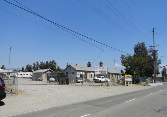
Property Record
14080 Jurupa Ave, Fontana, CA 92337

NEARBY LISTINGS FOR SALE OR LEASE
-
-
-
-
-
-
-
-
-
-
-
10513-10567 San Sevaine Way
Jurupa Valley, CA 91752
$3,222,139 - $3,427,861
10,212 - 10,864 SF
Industrial
-
-
-
-
-
-
-
View all Fontana listings for sale on LoopNet.com
Property Detail
14080 Jurupa Ave
Riverside-San Bernardino-Ontario, CA
Semi-Tropic Land & Water Co
0236-161-14
San Bernardino
Sfr
California
X
1.86 AC
06065C0036G
Airport Area
726 SF
Inland Empire (California)
DEMOGRAPHICS near 14080 Jurupa Ave
1 Mile
3 Mile
5 Mile
2024 Total Population
12,856
51,920
211,671
2029 Population
12,986
52,664
216,266
Pop Growth 2024-2029
+ 1.01%
+ 1.43%
+ 2.17%
Average Age
35
36
35
2024 Total Households
3,518
13,762
56,833
HH Growth 2024-2029
+ 1.02%
+ 1.32%
+ 2.13%
Median Household Inc
$81,228
$84,484
$83,794
Avg Household Size
3.70
3.70
3.60
2024 Avg HH Vehicles
3.00
3.00
2.00
Median Home Value
$412,823
$414,351
$465,315
Median Year Built
1985
1984
1985
Nearby Places
Map Layers
Map Styles
 Street
 Aerial
- Restaurants
- Banks
- Shops
- Fitness
- Groceries
PUBLIC TRANSPORTATION
COMMUTER RAIL
East Ontario (Riverside Line - Southern California Regional Rail Authority (Metrolink))
DRIVE
WALK
Distance
East Ontario (Riverside Line - Southern California Regional Rail Authority (Metrolink))
10 min
5.4 mi
Fontana (San Bernardino Line - Southern California Regional Rail Authority (Metrolink))
DRIVE
WALK
Distance
Fontana (San Bernardino Line - Southern California Regional Rail Authority (Metrolink))
12 min
6.3 mi
AIRPORT
Ontario International
DRIVE
WALK
Distance
Ontario International
13 min
7.2 mi
John Wayne/Orange County
DRIVE
WALK
Distance
John Wayne/Orange County
54 min
43.1 mi
Nearby Properties
Address
Land Use
TOTAL SIZE
Lot Size
Zoning
Address
Land Use
TOTAL SIZE
Lot Size
Zoning
362.37 AC
Address
Land Use
TOTAL SIZE
Lot Size
Zoning
425.43 AC
SDCOM
Address
Land Use
TOTAL SIZE
Lot Size
Zoning
1,379,287 SF
62.56 AC
Address
Land Use
TOTAL SIZE
Lot Size
Zoning
1,613,290 SF
59.42 AC
Address
Land Use
TOTAL SIZE
Lot Size
Zoning
817,750 SF
35.82 AC
Address
Land Use
TOTAL SIZE
Lot Size
Zoning
760,915 SF
30.34 AC
Address
Land Use
TOTAL SIZE
Lot Size
Zoning
912 SF
370.60 AC
IR
Address
Land Use
TOTAL SIZE
Lot Size
Zoning
1,286,569 SF
53.96 AC
Address
Land Use
TOTAL SIZE
Lot Size
Zoning
459,431 SF
23.10 AC
Address
Land Use
TOTAL SIZE
Lot Size
Zoning
34.80 AC
Address
Land Use
TOTAL SIZE
Lot Size
Zoning
444,668 SF
20.74 AC
Address
Land Use
TOTAL SIZE
Lot Size
Zoning
489,989 SF
24.49 AC
Address
Land Use
TOTAL SIZE
Lot Size
Zoning
560,025 SF
25.85 AC
Address
Land Use
TOTAL SIZE
Lot Size
Zoning
319,375 SF
14.66 AC
Address
Land Use
TOTAL SIZE
Lot Size
Zoning
1,003,567 SF
42.97 AC
Address
Land Use
TOTAL SIZE
Lot Size
Zoning
210,615 SF
9.42 AC
MM
Address
Land Use
TOTAL SIZE
Lot Size
Zoning
300,205 SF
12.63 AC
Address
Land Use
TOTAL SIZE
Lot Size
Zoning
76.50 AC
Address
Land Use
TOTAL SIZE
Lot Size
Zoning
19,440 SF
20.95 AC
M2
Address
Land Use
TOTAL SIZE
Lot Size
Zoning
849,900 SF
39.25 AC
KCSP
Address
Land Use
TOTAL SIZE
Lot Size
Zoning
282,224 SF
11.91 AC
Address
Land Use
TOTAL SIZE
Lot Size
Zoning
291,742 SF
12.10 AC
Address
Land Use
TOTAL SIZE
Lot Size
Zoning
263,188 SF
12.63 AC
Address
Land Use
TOTAL SIZE
Lot Size
Zoning
970,747 SF
19.56 AC
Address
Land Use
TOTAL SIZE
Lot Size
Zoning
194,595 SF
8.61 AC
Address
Land Use
TOTAL SIZE
Lot Size
Zoning
214,495 SF
9.89 AC
SDCOM
Address
Land Use
TOTAL SIZE
Lot Size
Zoning
784,500 SF
44.37 AC
MM
Address
Land Use
TOTAL SIZE
Lot Size
Zoning
330,048 SF
13.37 AC
Address
Land Use
TOTAL SIZE
Lot Size
Zoning
671,557 SF
30.78 AC
Address
Land Use
TOTAL SIZE
Lot Size
Zoning
42.45 AC
The World's #1 Commercial Real Estate Marketplace
Connect with us
© 2025 CoStar Group
The information above has been obtained from sources believed reliable. While we do not doubt its accuracy we have not verified it and make no guarantee, warranty or representation about it. It is your responsibility to independently confirm its accuracy and completeness. Any projections, opinions, assumptions, or estimates used are for example only and do not represent the current or future performance of the property. The value of this transaction to you depends on tax and other factors which should be evaluated by your tax, financial, and legal advisors. You and your advisors should conduct a careful, independent investigation of the property to determine to your satisfaction the suitability of the property for your needs.