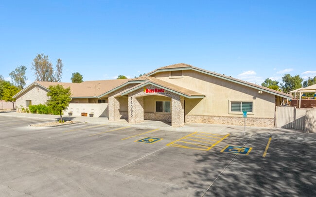
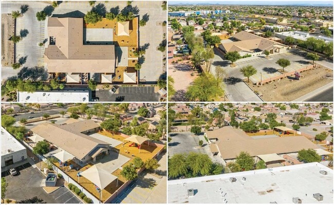
Property Record
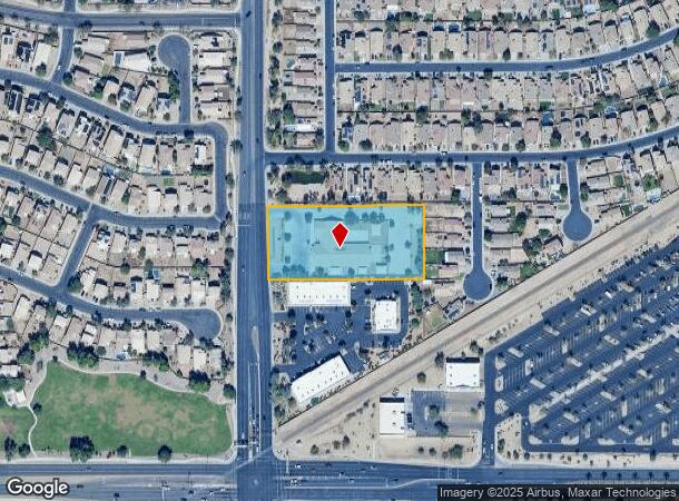
14085 N Dysart Rd, El Mirage, AZ 85335
NEARBY LISTINGS FOR SALE OR LEASE
Property Detail
14085 N Dysart Rd
501-33-011S
TH PT W2 SW4 SEC 11 DAF N 215F OF FOL DES PROP COM NW COR SW4 TH S 1826.99F TO POB TH CON S 693.72F TH N 58D 59M E 568.25F ALG NLY LN OF CALIFORNIA ARIZONA AND SANTA FE RAILWAY CO PROP TH N 406.82F TH W 490.50F TO POB EX W 33F RD TH/OF
Daycare
Maricopa
X
Arizona
04013C1680L
2.26 AC
2025
Sun City
2025
Phoenix
060901
Phoenix-Mesa-Scottsdale, AZ
13,533 SF
DEMOGRAPHICS near 14085 N Dysart Rd
1 Mile
3 Mile
5 Mile
2024 Total Population
19,723
105,590
221,906
2029 Population
20,982
113,658
239,455
Pop Growth 2024-2029
+ 6.38%
+ 7.64%
+ 7.91%
Average Age
35
41
49
2024 Total Households
5,941
37,525
93,554
HH Growth 2024-2029
+ 6.24%
+ 7.79%
+ 8.12%
Median Household Inc
$73,336
$67,971
$64,379
Avg Household Size
3.30
2.70
2.30
2024 Avg HH Vehicles
2.00
2.00
2.00
Median Home Value
$288,578
$292,518
$299,037
Median Year Built
2004
2001
1994
Nearby Places
Map Layers
Map Styles
 Street
 Aerial
- Restaurants
- Banks
- Shops
- Fitness
- Groceries
PUBLIC TRANSPORTATION
AIRPORT
Phoenix Sky Harbor International
DRIVE
WALK
Distance
Phoenix Sky Harbor International
44 min
32.0 mi
SALE & LEASE HISTORY
LISTING DATE
SALE/LEASE

Jan 08, 2025
For Sale
Feb 03, 2025
For Sale
Nearby Properties
Address
Land Use
TOTAL SIZE
Lot Size
Zoning
Address
Land Use
TOTAL SIZE
Lot Size
Zoning
290,294 SF
61.52 AC
PAD
Address
Land Use
TOTAL SIZE
Lot Size
Zoning
35.74 AC
Address
Land Use
TOTAL SIZE
Lot Size
Zoning
53.02 AC
Address
Land Use
TOTAL SIZE
Lot Size
Zoning
16,341 SF
174.45 AC
R-43
Address
Land Use
TOTAL SIZE
Lot Size
Zoning
575,121 SF
73.01 AC
PAD
Address
Land Use
TOTAL SIZE
Lot Size
Zoning
197,699 SF
40.78 AC
PAD
Address
Land Use
TOTAL SIZE
Lot Size
Zoning
294,360 SF
21.69 AC
EI
Address
Land Use
TOTAL SIZE
Lot Size
Zoning
225,457 SF
70.07 AC
PAD
Address
Land Use
TOTAL SIZE
Lot Size
Zoning
20,948 SF
2.39 AC
R-6
Address
Land Use
TOTAL SIZE
Lot Size
Zoning
67,417 SF
12.16 AC
PAD
Address
Land Use
TOTAL SIZE
Lot Size
Zoning
418,305 SF
24.06 AC
PAD
Address
Land Use
TOTAL SIZE
Lot Size
Zoning
333,066 SF
16.33 AC
PAD
Address
Land Use
TOTAL SIZE
Lot Size
Zoning
38,400 SF
4.97 AC
I-2
Address
Land Use
TOTAL SIZE
Lot Size
Zoning
247,178 SF
33.92 AC
PAD
Address
Land Use
TOTAL SIZE
Lot Size
Zoning
106,356 SF
14.16 AC
PAD
Address
Land Use
TOTAL SIZE
Lot Size
Zoning
90,636 SF
13.27 AC
PAD
Address
Land Use
TOTAL SIZE
Lot Size
Zoning
106,244 SF
13.55 AC
PAD
Address
Land Use
TOTAL SIZE
Lot Size
Zoning
236,026 SF
6.66 AC
PAD
Address
Land Use
TOTAL SIZE
Lot Size
Zoning
77,400 SF
20.34 AC
PAD
Address
Land Use
TOTAL SIZE
Lot Size
Zoning
145,491 SF
37.61 AC
PAD
Address
Land Use
TOTAL SIZE
Lot Size
Zoning
104,619 SF
11.45 AC
PAD
Address
Land Use
TOTAL SIZE
Lot Size
Zoning
707,380 SF
46.26 AC
I-2
Address
Land Use
TOTAL SIZE
Lot Size
Zoning
67,932 SF
14.90 AC
PAD
Address
Land Use
TOTAL SIZE
Lot Size
Zoning
199,390 SF
24.59 AC
C-C
Address
Land Use
TOTAL SIZE
Lot Size
Zoning
89,601 SF
19.92 AC
PAD
Address
Land Use
TOTAL SIZE
Lot Size
Zoning
65,749 SF
14.58 AC
PAD
Address
Land Use
TOTAL SIZE
Lot Size
Zoning
270,000 SF
16.26 AC
PAD
Address
Land Use
TOTAL SIZE
Lot Size
Zoning
65,711 SF
8.62 AC
PAD
Address
Land Use
TOTAL SIZE
Lot Size
Zoning
153,525 SF
14.48 AC
PAD
Address
Land Use
TOTAL SIZE
Lot Size
Zoning
112,957 SF
17.40 AC
PAD
The World's #1 Commercial Real Estate Marketplace
Connect with us
© 2025 CoStar Group
The information above has been obtained from sources believed reliable. While we do not doubt its accuracy we have not verified it and make no guarantee, warranty or representation about it. It is your responsibility to independently confirm its accuracy and completeness. Any projections, opinions, assumptions, or estimates used are for example only and do not represent the current or future performance of the property. The value of this transaction to you depends on tax and other factors which should be evaluated by your tax, financial, and legal advisors. You and your advisors should conduct a careful, independent investigation of the property to determine to your satisfaction the suitability of the property for your needs.