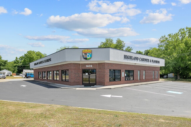
Property Record
1409 Clinton Rd, Fayetteville, NC 28312


Current Lease Availabilities
NEARBY LISTINGS FOR SALE OR LEASE
Property Detail
1409 Clinton Rd
Fayetteville, NC
Nc53/Nc24 To N/H 8021 Line
0447-41-5704
GARY L STRICKLAND LO:1 SE:01 PL:0128-0103
Storebuilding
Cumberland
AE
North Carolina
3720044700K
1
2025
1.07 AC
2024
East Fayetteville
001402
Fayetteville
5,165 SF
DEMOGRAPHICS near 1409 Clinton Rd
1 Mile
3 Mile
5 Mile
2024 Total Population
2,443
17,002
60,102
2029 Population
2,502
17,352
60,500
Pop Growth 2024-2029
+ 2.42%
+ 2.06%
+ 0.66%
Average Age
36
39
39
2024 Total Households
995
7,089
25,224
HH Growth 2024-2029
+ 2.51%
+ 2.14%
+ 0.64%
Median Household Inc
$28,008
$35,143
$44,363
Avg Household Size
2.40
2.20
2.20
2024 Avg HH Vehicles
1.00
1.00
2.00
Median Home Value
$113,303
$150,335
$166,950
Median Year Built
1987
1978
1975
Nearby Places
- Restaurants
- Banks
- Shops
- Fitness
- Groceries
PUBLIC TRANSPORTATION
COMMUTER RAIL
Fayetteville Amtrak Station (Palmetto - Amtrak, Silver Meteor - Amtrak)
DRIVE
WALK
Distance
Fayetteville Amtrak Station (Palmetto - Amtrak, Silver Meteor - Amtrak)
4 min
2.1 mi
AIRPORT
Fayetteville Regional/Grannis Field
DRIVE
WALK
Distance
Fayetteville Regional/Grannis Field
10 min
6.0 mi
Freight Ports
Port of Wilmington
DRIVE
WALK
Distance
Port of Wilmington
125 min
87.4 mi
Nearby Properties
Address
Land Use
TOTAL SIZE
Lot Size
Zoning
Address
Land Use
TOTAL SIZE
Lot Size
Zoning
46,110 SF
25.72 AC
OI
Address
Land Use
TOTAL SIZE
Lot Size
Zoning
91,620 SF
9.67 AC
CC
Address
Land Use
TOTAL SIZE
Lot Size
Zoning
37,786 SF
9.55 AC
CC
Address
Land Use
TOTAL SIZE
Lot Size
Zoning
11,894 SF
8.39 AC
DTCZ
Address
Land Use
TOTAL SIZE
Lot Size
Zoning
28,107 SF
34.33 AC
HI
Address
Land Use
TOTAL SIZE
Lot Size
Zoning
1 AC
DTCZ
Address
Land Use
TOTAL SIZE
Lot Size
Zoning
27,825 SF
1.67 AC
DT
Address
Land Use
TOTAL SIZE
Lot Size
Zoning
4,602 SF
29.92 AC
MR5
Address
Land Use
TOTAL SIZE
Lot Size
Zoning
1.64 AC
DTCZ-DOWNT
Address
Land Use
TOTAL SIZE
Lot Size
Zoning
4,690 SF
11.13 AC
MR5
Address
Land Use
TOTAL SIZE
Lot Size
Zoning
26,818 SF
OI-OFFICE
Address
Land Use
TOTAL SIZE
Lot Size
Zoning
4,141 SF
11.72 AC
MR5
Address
Land Use
TOTAL SIZE
Lot Size
Zoning
40,786 SF
3.80 AC
DT
Address
Land Use
TOTAL SIZE
Lot Size
Zoning
26,818 SF
10.76 AC
OI
Address
Land Use
TOTAL SIZE
Lot Size
Zoning
94,791 SF
18.04 AC
HI
Address
Land Use
TOTAL SIZE
Lot Size
Zoning
7,210 SF
1.81 AC
DT
Address
Land Use
TOTAL SIZE
Lot Size
Zoning
2,582 SF
5.32 AC
MR5
Address
Land Use
TOTAL SIZE
Lot Size
Zoning
33,266 SF
4.15 AC
CC
Address
Land Use
TOTAL SIZE
Lot Size
Zoning
10,550 SF
2.56 AC
DT
Address
Land Use
TOTAL SIZE
Lot Size
Zoning
17,622 SF
17 AC
SF10
Address
Land Use
TOTAL SIZE
Lot Size
Zoning
24,350 SF
4.30 AC
OI
Address
Land Use
TOTAL SIZE
Lot Size
Zoning
5,675 SF
29 AC
HI
Address
Land Use
TOTAL SIZE
Lot Size
Zoning
17,640 SF
0.72 AC
DTCZ
Address
Land Use
TOTAL SIZE
Lot Size
Zoning
74,169 SF
3.90 AC
DT
Address
Land Use
TOTAL SIZE
Lot Size
Zoning
28,734 SF
2.32 AC
DT
Address
Land Use
TOTAL SIZE
Lot Size
Zoning
3.59 AC
CC
Address
Land Use
TOTAL SIZE
Lot Size
Zoning
8,427 SF
6.07 AC
MUC
Address
Land Use
TOTAL SIZE
Lot Size
Zoning
15,542 SF
2.17 AC
MR5
Address
Land Use
TOTAL SIZE
Lot Size
Zoning
13,231 SF
59.66 AC
MP
Address
Land Use
TOTAL SIZE
Lot Size
Zoning
2,582 SF
6.33 AC
MR5
The World's #1 Commercial Real Estate Marketplace
Connect with us
© 2025 CoStar Group
The information above has been obtained from sources believed reliable. While we do not doubt its accuracy we have not verified it and make no guarantee, warranty or representation about it. It is your responsibility to independently confirm its accuracy and completeness. Any projections, opinions, assumptions, or estimates used are for example only and do not represent the current or future performance of the property. The value of this transaction to you depends on tax and other factors which should be evaluated by your tax, financial, and legal advisors. You and your advisors should conduct a careful, independent investigation of the property to determine to your satisfaction the suitability of the property for your needs.