Property Record
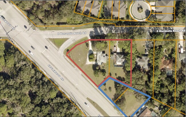
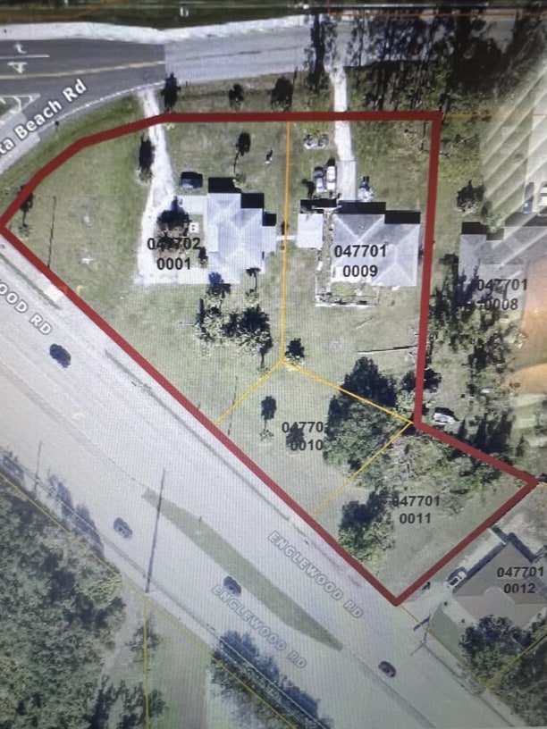
1409 E Manasota Beach Rd, Englewood, FL 34223
This Property Is For Sale
NEARBY LISTINGS FOR SALE OR LEASE
Property Detail
1409 E Manasota Beach Rd
North Port-Sarasota-Bradenton, FL
Manasota Acres
0477-01-0009
LOT 15 BLK A LESS R/W FOR SR 776 IN OR 2749/2269 MANASOTA ACRES
Sfr
Sarasota
X
Florida
12115C0344G
15
2024
0.42 AC
2025
Sarasota Outlying
002604
Tampa/St Petersburg
1,403 SF
DEMOGRAPHICS near 1409 E Manasota Beach Rd
1 Mile
3 Mile
5 Mile
2024 Total Population
3,835
31,801
71,301
2029 Population
4,440
36,857
82,652
Pop Growth 2024-2029
+ 15.78%
+ 15.90%
+ 15.92%
Average Age
57
58
58
2024 Total Households
1,852
15,660
34,912
HH Growth 2024-2029
+ 15.87%
+ 15.96%
+ 15.96%
Median Household Inc
$72,145
$73,810
$74,252
Avg Household Size
2.00
2.00
2.00
2024 Avg HH Vehicles
2.00
2.00
2.00
Median Home Value
$325,270
$329,945
$328,409
Median Year Built
1995
1993
1992
Nearby Places
Map Layers
Map Styles
 Street
 Aerial
- Restaurants
- Banks
- Shops
- Fitness
- Groceries
PUBLIC TRANSPORTATION
AIRPORT
Sarasota/Bradenton International
DRIVE
WALK
Distance
Sarasota/Bradenton International
49 min
35.7 mi
Punta Gorda
DRIVE
WALK
Distance
Punta Gorda
50 min
39.5 mi
Freight Ports
Port Manatee
DRIVE
WALK
Distance
Port Manatee
62 min
48.3 mi
Nearby Properties
Address
Land Use
TOTAL SIZE
Lot Size
Zoning
Address
Land Use
TOTAL SIZE
Lot Size
Zoning
251,872 SF
25.01 AC
RMF2
Address
Land Use
TOTAL SIZE
Lot Size
Zoning
173,966 SF
17 AC
CG
Address
Land Use
TOTAL SIZE
Lot Size
Zoning
149,834 SF
36.95 AC
GU
Address
Land Use
TOTAL SIZE
Lot Size
Zoning
219.10 AC
V
Address
Land Use
TOTAL SIZE
Lot Size
Zoning
159,759 SF
12.60 AC
RMF3
Address
Land Use
TOTAL SIZE
Lot Size
Zoning
201,992 SF
22.45 AC
CG
Address
Land Use
TOTAL SIZE
Lot Size
Zoning
85,177 SF
68.01 AC
RE1
Address
Land Use
TOTAL SIZE
Lot Size
Zoning
101,496 SF
19.08 AC
CG
Address
Land Use
TOTAL SIZE
Lot Size
Zoning
119,222 SF
12.47 AC
CG
Address
Land Use
TOTAL SIZE
Lot Size
Zoning
94,453 SF
10.11 AC
CG
Address
Land Use
TOTAL SIZE
Lot Size
Zoning
79,048 SF
6.92 AC
CI
Address
Land Use
TOTAL SIZE
Lot Size
Zoning
121,850 SF
8.98 AC
CG
Address
Land Use
TOTAL SIZE
Lot Size
Zoning
90,484 SF
4.35 AC
CG
Address
Land Use
TOTAL SIZE
Lot Size
Zoning
136.72 AC
OUC
Address
Land Use
TOTAL SIZE
Lot Size
Zoning
82,874 SF
7.08 AC
CG
Address
Land Use
TOTAL SIZE
Lot Size
Zoning
43,592 SF
173.68 AC
RE1
Address
Land Use
TOTAL SIZE
Lot Size
Zoning
77,851 SF
1.11 AC
RMF2
Address
Land Use
TOTAL SIZE
Lot Size
Zoning
4,401 SF
19.27 AC
RMH
Address
Land Use
TOTAL SIZE
Lot Size
Zoning
34,401 SF
76.70 AC
GU
Address
Land Use
TOTAL SIZE
Lot Size
Zoning
30,476 SF
3.82 AC
CI
Address
Land Use
TOTAL SIZE
Lot Size
Zoning
77,801 SF
3.16 AC
CG
Address
Land Use
TOTAL SIZE
Lot Size
Zoning
9,519 SF
1.13 AC
RE2
Address
Land Use
TOTAL SIZE
Lot Size
Zoning
4,990 SF
11.86 AC
OUE1
Address
Land Use
TOTAL SIZE
Lot Size
Zoning
18,980 SF
2.71 AC
CI
Address
Land Use
TOTAL SIZE
Lot Size
Zoning
18,800 SF
3.45 AC
CI
Address
Land Use
TOTAL SIZE
Lot Size
Zoning
19,568 SF
1.68 AC
RMF2
Address
Land Use
TOTAL SIZE
Lot Size
Zoning
59,857 SF
2.67 AC
CI
Address
Land Use
TOTAL SIZE
Lot Size
Zoning
20,756 SF
2.91 AC
CI
Address
Land Use
TOTAL SIZE
Lot Size
Zoning
6,059 SF
2.15 AC
CI
Address
Land Use
TOTAL SIZE
Lot Size
Zoning
8,448 SF
1.46 AC
RE2
The World's #1 Commercial Real Estate Marketplace
Connect with us
© 2025 CoStar Group
The information above has been obtained from sources believed reliable. While we do not doubt its accuracy we have not verified it and make no guarantee, warranty or representation about it. It is your responsibility to independently confirm its accuracy and completeness. Any projections, opinions, assumptions, or estimates used are for example only and do not represent the current or future performance of the property. The value of this transaction to you depends on tax and other factors which should be evaluated by your tax, financial, and legal advisors. You and your advisors should conduct a careful, independent investigation of the property to determine to your satisfaction the suitability of the property for your needs.