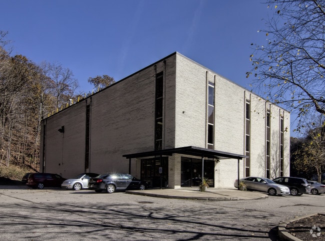
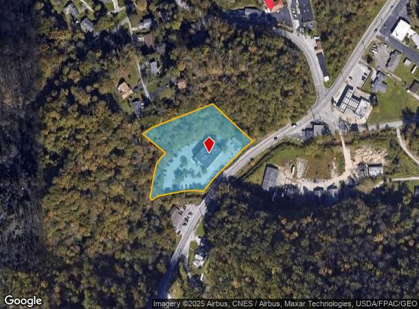
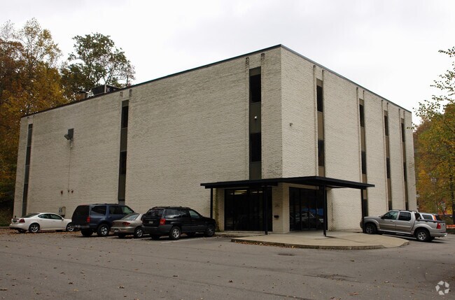
Property Record
1409 Greenbrier St, Charleston, WV 25311
NEARBY LISTINGS FOR SALE OR LEASE
Property Detail
1409 Greenbrier St
Charleston, WV
2-44/100AC M/L SURF LT B CABELL
10-59-00280000
Kanawha
Officebuilding
West Virginia
AE
b
54039C0427E
2.44 AC
0
Outlying Kanawha County
2025
Charleston WV
011301
DEMOGRAPHICS near 1409 Greenbrier St
1 Mile
3 Mile
5 Mile
2024 Total Population
729
21,501
55,111
2029 Population
700
20,986
53,785
Pop Growth 2024-2029
(3.98%)
(2.40%)
(2.41%)
Average Age
45
44
43
2024 Total Households
318
10,234
25,415
HH Growth 2024-2029
(4.09%)
(2.37%)
(2.40%)
Median Household Inc
$79,167
$51,176
$56,357
Avg Household Size
2.20
1.90
2.10
2024 Avg HH Vehicles
2.00
1.00
1.00
Median Home Value
$325,333
$172,209
$162,139
Median Year Built
1977
1957
1958
Nearby Places
Map Layers
Map Styles
 Street
 Aerial
- Restaurants
- Banks
- Shops
- Fitness
- Groceries
PUBLIC TRANSPORTATION
COMMUTER RAIL
DRIVE
WALK
Distance
8 min
4.4 mi
AIRPORT
West Virginia International Yeager
DRIVE
WALK
Distance
West Virginia International Yeager
6 min
1.5 mi
Nearby Properties
Address
Land Use
TOTAL SIZE
Lot Size
Zoning
Address
Land Use
TOTAL SIZE
Lot Size
Zoning
4.27 AC
Address
Land Use
TOTAL SIZE
Lot Size
Zoning
Address
Land Use
TOTAL SIZE
Lot Size
Zoning
14.32 AC
Address
Land Use
TOTAL SIZE
Lot Size
Zoning
Address
Land Use
TOTAL SIZE
Lot Size
Zoning
Address
Land Use
TOTAL SIZE
Lot Size
Zoning
Address
Land Use
TOTAL SIZE
Lot Size
Zoning
2.27 AC
Address
Land Use
TOTAL SIZE
Lot Size
Zoning
Address
Land Use
TOTAL SIZE
Lot Size
Zoning
Address
Land Use
TOTAL SIZE
Lot Size
Zoning
121.80 AC
Address
Land Use
TOTAL SIZE
Lot Size
Zoning
0.39 AC
Address
Land Use
TOTAL SIZE
Lot Size
Zoning
36.08 AC
Address
Land Use
TOTAL SIZE
Lot Size
Zoning
24.42 AC
Address
Land Use
TOTAL SIZE
Lot Size
Zoning
Address
Land Use
TOTAL SIZE
Lot Size
Zoning
Address
Land Use
TOTAL SIZE
Lot Size
Zoning
1.99 AC
Address
Land Use
TOTAL SIZE
Lot Size
Zoning
0.56 AC
Address
Land Use
TOTAL SIZE
Lot Size
Zoning
0.86 AC
Address
Land Use
TOTAL SIZE
Lot Size
Zoning
Address
Land Use
TOTAL SIZE
Lot Size
Zoning
2.71 AC
Address
Land Use
TOTAL SIZE
Lot Size
Zoning
0.42 AC
Address
Land Use
TOTAL SIZE
Lot Size
Zoning
Address
Land Use
TOTAL SIZE
Lot Size
Zoning
2.71 AC
Address
Land Use
TOTAL SIZE
Lot Size
Zoning
11.51 AC
Address
Land Use
TOTAL SIZE
Lot Size
Zoning
Address
Land Use
TOTAL SIZE
Lot Size
Zoning
Address
Land Use
TOTAL SIZE
Lot Size
Zoning
Address
Land Use
TOTAL SIZE
Lot Size
Zoning
0.33 AC
Address
Land Use
TOTAL SIZE
Lot Size
Zoning
161.09 AC
Address
Land Use
TOTAL SIZE
Lot Size
Zoning
1.33 AC
The World's #1 Commercial Real Estate Marketplace
Connect with us
© 2026 CoStar Group
The information above has been obtained from sources believed reliable. While we do not doubt its accuracy we have not verified it and make no guarantee, warranty or representation about it. It is your responsibility to independently confirm its accuracy and completeness. Any projections, opinions, assumptions, or estimates used are for example only and do not represent the current or future performance of the property. The value of this transaction to you depends on tax and other factors which should be evaluated by your tax, financial, and legal advisors. You and your advisors should conduct a careful, independent investigation of the property to determine to your satisfaction the suitability of the property for your needs.