Property Record
14091 Sr 31, Punta Gorda, FL 33982

NEARBY LISTINGS FOR SALE OR LEASE
-
-
View all Punta Gorda listings for sale on LoopNet.com
Property Detail
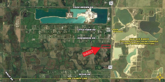
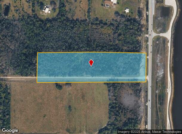
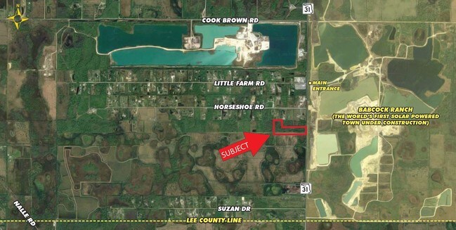
14091 Sr 31
422536200005
Subj To Res
Agriculturalland
36 42 25 P-1-1 10 AC. M/L TH S1/2 OF N1/2 OF NE1/4 OF NE1/4 SUBJ TO RESERVATION OVER S 33FT THEREOF FOR PERPETUAL ROAD PURPOSES 314/262 352/964 942/964 E1791/239 4394/273
D
Charlotte
12015C0475G
Florida
2024
10 AC
2025
Charlotte County
010200
Southwest Florida
960 SF
Punta Gorda, FL
DEMOGRAPHICS near 14091 Sr 31
1 Mile
3 Mile
5 Mile
2024 Total Population
737
5,107
9,848
2029 Population
929
6,370
11,934
Pop Growth 2024-2029
+ 26.05%
+ 24.73%
+ 21.18%
Average Age
46
46
45
2024 Total Households
298
1,995
3,806
HH Growth 2024-2029
+ 26.51%
+ 25.36%
+ 21.47%
Median Household Inc
$90,104
$90,527
$79,876
Avg Household Size
2.40
2.40
2.40
2024 Avg HH Vehicles
2.00
2.00
2.00
Median Home Value
$361,445
$368,345
$339,548
Median Year Built
2010
2010
1991
Nearby Places
Map Layers
Map Styles
 Street
 Aerial
- Restaurants
- Banks
- Shops
- Fitness
- Groceries
PUBLIC TRANSPORTATION
AIRPORT
Southwest Florida International
DRIVE
WALK
Distance
Southwest Florida International
32 min
21.4 mi
Punta Gorda
DRIVE
WALK
Distance
Punta Gorda
36 min
26.8 mi
Freight Ports
Port Manatee
DRIVE
WALK
Distance
Port Manatee
116 min
98.5 mi
SALE & LEASE HISTORY
LISTING DATE
SALE/LEASE

Sep 24, 2016
For Sale
Jan 26, 2017
For Sale
Nearby Properties
Address
Land Use
TOTAL SIZE
Lot Size
Zoning
Address
Land Use
TOTAL SIZE
Lot Size
Zoning
367,053 SF
17 AC
BOZD
Address
Land Use
TOTAL SIZE
Lot Size
Zoning
9,424 SF
6,734.78 AC
BOZD
Address
Land Use
TOTAL SIZE
Lot Size
Zoning
309.30 AC
MPD
Address
Land Use
TOTAL SIZE
Lot Size
Zoning
83,212 SF
12.96 AC
BOZD
Address
Land Use
TOTAL SIZE
Lot Size
Zoning
74,698 SF
8.33 AC
BOZD
Address
Land Use
TOTAL SIZE
Lot Size
Zoning
40,490 SF
1.95 AC
BOZD
Address
Land Use
TOTAL SIZE
Lot Size
Zoning
10,304 SF
141.77 AC
BOZD
Address
Land Use
TOTAL SIZE
Lot Size
Zoning
16.06 AC
BOZD
Address
Land Use
TOTAL SIZE
Lot Size
Zoning
18,224 SF
3.56 AC
BOZD
Address
Land Use
TOTAL SIZE
Lot Size
Zoning
11,223 SF
1.15 AC
BOZD
Address
Land Use
TOTAL SIZE
Lot Size
Zoning
85.73 AC
MPD
Address
Land Use
TOTAL SIZE
Lot Size
Zoning
116,525 SF
10 AC
BOZD
Address
Land Use
TOTAL SIZE
Lot Size
Zoning
49,980 SF
159.94 AC
II
Address
Land Use
TOTAL SIZE
Lot Size
Zoning
9,017 SF
1.86 AC
CR
Address
Land Use
TOTAL SIZE
Lot Size
Zoning
1,600 SF
477 AC
ES
Address
Land Use
TOTAL SIZE
Lot Size
Zoning
10,725 SF
80 AC
AG
Address
Land Use
TOTAL SIZE
Lot Size
Zoning
6,030 SF
0.24 AC
BOZD
Address
Land Use
TOTAL SIZE
Lot Size
Zoning
702 SF
6.42 AC
BOZD
Address
Land Use
TOTAL SIZE
Lot Size
Zoning
5,547 SF
0.30 AC
BOZD
Address
Land Use
TOTAL SIZE
Lot Size
Zoning
185.23 AC
MPD
Address
Land Use
TOTAL SIZE
Lot Size
Zoning
6,936 SF
154.71 AC
BOZD
Address
Land Use
TOTAL SIZE
Lot Size
Zoning
12,524 SF
33.01 AC
BOZD
Address
Land Use
TOTAL SIZE
Lot Size
Zoning
61.85 AC
BOZD
Address
Land Use
TOTAL SIZE
Lot Size
Zoning
10,604 SF
79.30 AC
AG-2
Address
Land Use
TOTAL SIZE
Lot Size
Zoning
1.98 AC
BOZD
Address
Land Use
TOTAL SIZE
Lot Size
Zoning
17,581 SF
5 AC
IG
Address
Land Use
TOTAL SIZE
Lot Size
Zoning
1,260 SF
5 AC
IG
Address
Land Use
TOTAL SIZE
Lot Size
Zoning
5,054 SF
0.23 AC
BOZD
Address
Land Use
TOTAL SIZE
Lot Size
Zoning
1,440 SF
18.76 AC
BOZD
Address
Land Use
TOTAL SIZE
Lot Size
Zoning
3.63 AC
BOZD
The World's #1 Commercial Real Estate Marketplace
Connect with us
© 2026 CoStar Group
The information above has been obtained from sources believed reliable. While we do not doubt its accuracy we have not verified it and make no guarantee, warranty or representation about it. It is your responsibility to independently confirm its accuracy and completeness. Any projections, opinions, assumptions, or estimates used are for example only and do not represent the current or future performance of the property. The value of this transaction to you depends on tax and other factors which should be evaluated by your tax, financial, and legal advisors. You and your advisors should conduct a careful, independent investigation of the property to determine to your satisfaction the suitability of the property for your needs.