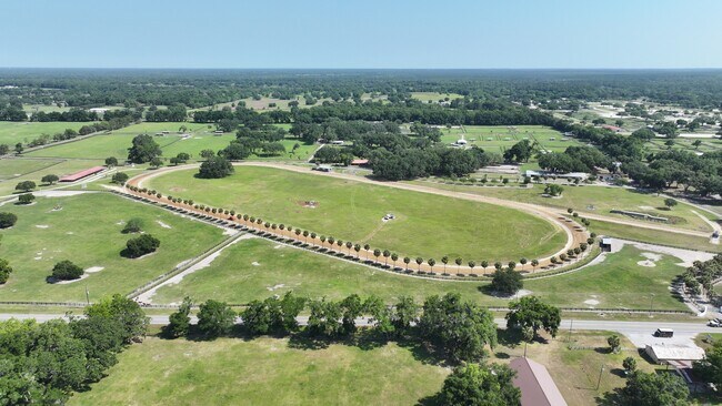
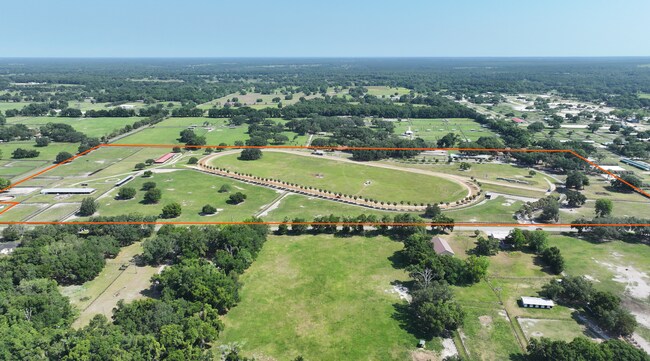
Property Record
14091 W Highway 326, Morriston, FL 32668

NEARBY LISTINGS FOR SALE OR LEASE
-
-
View all Morriston listings for sale on LoopNet.com
Property Detail
14091 W Highway 326
12141-000-00
SEC 12 TWP 14 RGE 19 N 1/2 OF NE 1/4 EXC 1 SQ A IN SW COR EXC THAT PT LYING S OF SR 326
Pasture
Marion
AE
Florida
12083C0286D
78 AC
2025
Outlying Marion County
2025
Ocala
000101
Ocala, FL
4,130 SF
DEMOGRAPHICS near 14091 W Highway 326
1 Mile
3 Mile
5 Mile
2024 Total Population
242
1,416
3,142
2029 Population
276
1,613
3,578
Pop Growth 2024-2029
+ 14.05%
+ 13.91%
+ 13.88%
Average Age
50
49
48
2024 Total Households
113
657
1,391
HH Growth 2024-2029
+ 14.16%
+ 13.85%
+ 13.80%
Median Household Inc
$76,136
$74,540
$61,559
Avg Household Size
2.10
2.10
2.20
2024 Avg HH Vehicles
2.00
2.00
2.00
Median Home Value
$354,545
$352,590
$330,337
Median Year Built
1990
1989
1990
Nearby Places
Map Layers
Map Styles
 Street
 Aerial
- Restaurants
- Banks
- Shops
- Fitness
- Groceries
PUBLIC TRANSPORTATION
AIRPORT
Gainesville Regional
DRIVE
WALK
Distance
Gainesville Regional
59 min
36.8 mi
Freight Ports
Jacksonville Port
DRIVE
WALK
Distance
Jacksonville Port
144 min
106.6 mi
SALE & LEASE HISTORY
LISTING DATE
SALE/LEASE

May 13, 2024
For Sale
Nearby Properties
Address
Land Use
TOTAL SIZE
Lot Size
Zoning
Address
Land Use
TOTAL SIZE
Lot Size
Zoning
23,580 SF
310.73 AC
A1
Address
Land Use
TOTAL SIZE
Lot Size
Zoning
98,724 SF
13.10 AC
A1
Address
Land Use
TOTAL SIZE
Lot Size
Zoning
21,022 SF
453.55 AC
A1
Address
Land Use
TOTAL SIZE
Lot Size
Zoning
11,540 SF
68.67 AC
A1
Address
Land Use
TOTAL SIZE
Lot Size
Zoning
6,855 SF
42.76 AC
A1
Address
Land Use
TOTAL SIZE
Lot Size
Zoning
31,920 SF
11.03 AC
RAC
Address
Land Use
TOTAL SIZE
Lot Size
Zoning
9,776 SF
10.26 AC
A1
Address
Land Use
TOTAL SIZE
Lot Size
Zoning
2,707 SF
39.45 AC
A1
Address
Land Use
TOTAL SIZE
Lot Size
Zoning
11,811 SF
45.65 AC
A1
Address
Land Use
TOTAL SIZE
Lot Size
Zoning
4,668 SF
40.97 AC
A1
Address
Land Use
TOTAL SIZE
Lot Size
Zoning
7,084 SF
113 AC
A1
Address
Land Use
TOTAL SIZE
Lot Size
Zoning
7,368 SF
11.28 AC
A1
Address
Land Use
TOTAL SIZE
Lot Size
Zoning
5,731 SF
9.43 AC
A1
Address
Land Use
TOTAL SIZE
Lot Size
Zoning
7,663 SF
412.91 AC
A1
Address
Land Use
TOTAL SIZE
Lot Size
Zoning
9,100 SF
3.08 AC
RAC
Address
Land Use
TOTAL SIZE
Lot Size
Zoning
5,032 SF
21.84 AC
A1
Address
Land Use
TOTAL SIZE
Lot Size
Zoning
3,996 SF
119.35 AC
A1
Address
Land Use
TOTAL SIZE
Lot Size
Zoning
4,354 SF
66.60 AC
A1
Address
Land Use
TOTAL SIZE
Lot Size
Zoning
6,009 SF
37.28 AC
A1
Address
Land Use
TOTAL SIZE
Lot Size
Zoning
3,793 SF
53.88 AC
A1
Address
Land Use
TOTAL SIZE
Lot Size
Zoning
9,240 SF
13.58 AC
A1
Address
Land Use
TOTAL SIZE
Lot Size
Zoning
4,911 SF
13 AC
A1
Address
Land Use
TOTAL SIZE
Lot Size
Zoning
5,435 SF
61.22 AC
A1
Address
Land Use
TOTAL SIZE
Lot Size
Zoning
3,130 SF
5.30 AC
RAC
Address
Land Use
TOTAL SIZE
Lot Size
Zoning
4,694 SF
16.49 AC
A1
Address
Land Use
TOTAL SIZE
Lot Size
Zoning
4,292 SF
10 AC
6010
Address
Land Use
TOTAL SIZE
Lot Size
Zoning
3,726 SF
4.55 AC
A1
Address
Land Use
TOTAL SIZE
Lot Size
Zoning
2,885 SF
14.73 AC
A1
Address
Land Use
TOTAL SIZE
Lot Size
Zoning
3,970 SF
11.21 AC
A1
Address
Land Use
TOTAL SIZE
Lot Size
Zoning
5,987 SF
10 AC
A1
The World's #1 Commercial Real Estate Marketplace
Connect with us
© 2026 CoStar Group
The information above has been obtained from sources believed reliable. While we do not doubt its accuracy we have not verified it and make no guarantee, warranty or representation about it. It is your responsibility to independently confirm its accuracy and completeness. Any projections, opinions, assumptions, or estimates used are for example only and do not represent the current or future performance of the property. The value of this transaction to you depends on tax and other factors which should be evaluated by your tax, financial, and legal advisors. You and your advisors should conduct a careful, independent investigation of the property to determine to your satisfaction the suitability of the property for your needs.