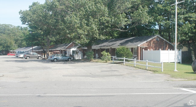
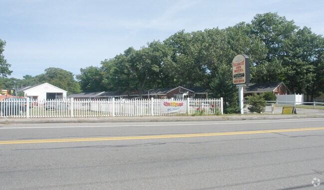
Property Record
141 Beach Rd, Salisbury, MA 01952

Property Detail
141 Beach Rd
Commercialofficeresidentialmixeduse
Essex
C
Massachusetts
AE The base floodplain where base flood elevations are provided. AE Zones are now used on new format FIRMs instead of A1-A30 Zones.
3.90 AC
2025
Andover/Danvers Northeast
2025
Boston
267104
Boston-Cambridge-Newton, MA-NH
20,684 SF
SALI-000025-000000-000025
NEARBY LISTINGS FOR SALE OR LEASE
-
-
View all Salisbury listings for sale on LoopNet.com
DEMOGRAPHICS near 141 Beach Rd
1 mile
3 mile
5 mile
2025 Total Population
2,754
21,416
51,977
2030 Population
2,822
22,187
54,067
Pop Growth 2025-2030
+ 2.47%
+ 3.60%
+ 4.02%
Average Age
50
49
47
2025 Total Households
1,435
10,100
23,214
HH Growth 2025-2030
+ 2.58%
+ 3.68%
+ 4.08%
Median Household Inc
$86,259
$108,155
$105,901
Avg Household Size
1.90
2.10
2.20
2025 Avg HH Vehicles
2.00
2.00
2.00
Median Home Value
$487,646
$713,863
$700,553
Median Year Built
1983
1963
1968
Nearby Places
Map Layers
Map Styles
 Street
 Aerial
Transit
 Traffic
 Biking
Places
Listings with unknown addresses are not visible on the map
- Restaurants
- Banks
- Shops
- Fitness
- Groceries
PUBLIC TRANSPORTATION
COMMUTER RAIL
Newburyport (Newburyport/Rockport Line - Massachusetts Bay Transportation Authority Commuter Rail (Purple Line))
Drive
Walk
Distance
Newburyport (Newburyport/Rockport Line - Massachusetts Bay Transportation Authority Commuter Rail (Purple Line))
12 min
4.8 mi
AIRPORT
Portsmouth International at Pease
Drive
Walk
Distance
Portsmouth International at Pease
31 min
20.5 mi
Freight Ports
Port of Boston
Drive
Walk
Distance
Port of Boston
62 min
44.2 mi
SALE & LEASE HISTORY
LISTING DATE
SALE/LEASE

Aug 30, 2018
For Sale
Nearby Properties
Address
Land Use
TOTAL SIZE
Lot Size
Zoning
Address
Land Use
TOTAL SIZE
Lot Size
Zoning
267,857 SF
13.10 AC
BC
Address
Land Use
TOTAL SIZE
Lot Size
Zoning
441.30 AC
BC
Address
Land Use
TOTAL SIZE
Lot Size
Zoning
112,708 SF
40 AC
50
Address
Land Use
TOTAL SIZE
Lot Size
Zoning
3,820 SF
9.15 AC
40
Address
Land Use
TOTAL SIZE
Lot Size
Zoning
7,768 SF
3.98 AC
Address
Land Use
TOTAL SIZE
Lot Size
Zoning
106,787 SF
22.25 AC
C
Address
Land Use
TOTAL SIZE
Lot Size
Zoning
20,518 SF
6.05 AC
BC
Address
Land Use
TOTAL SIZE
Lot Size
Zoning
95,903 SF
1.64 AC
Address
Land Use
TOTAL SIZE
Lot Size
Zoning
148,744 SF
4.10 AC
Address
Land Use
TOTAL SIZE
Lot Size
Zoning
Address
Land Use
TOTAL SIZE
Lot Size
Zoning
65,124 SF
0.79 AC
Address
Land Use
TOTAL SIZE
Lot Size
Zoning
92,907 SF
5.76 AC
Address
Land Use
TOTAL SIZE
Lot Size
Zoning
52.50 AC
Address
Land Use
TOTAL SIZE
Lot Size
Zoning
39,728 SF
2.25 AC
Address
Land Use
TOTAL SIZE
Lot Size
Zoning
144 SF
9.18 AC
BC
Address
Land Use
TOTAL SIZE
Lot Size
Zoning
36,701 SF
1.10 AC
Address
Land Use
TOTAL SIZE
Lot Size
Zoning
30,270 SF
0.74 AC
Address
Land Use
TOTAL SIZE
Lot Size
Zoning
4.11 AC
Address
Land Use
TOTAL SIZE
Lot Size
Zoning
33,675 SF
27.18 AC
C3
Address
Land Use
TOTAL SIZE
Lot Size
Zoning
11,445 SF
0.75 AC
Address
Land Use
TOTAL SIZE
Lot Size
Zoning
42.20 AC
C1
Address
Land Use
TOTAL SIZE
Lot Size
Zoning
52,767 SF
5.61 AC
C
Address
Land Use
TOTAL SIZE
Lot Size
Zoning
96,232 SF
5.81 AC
I
Address
Land Use
TOTAL SIZE
Lot Size
Zoning
79,908 SF
0.67 AC
Address
Land Use
TOTAL SIZE
Lot Size
Zoning
19,258 SF
0.63 AC
Address
Land Use
TOTAL SIZE
Lot Size
Zoning
17,360 SF
1.08 AC
VC
Address
Land Use
TOTAL SIZE
Lot Size
Zoning
16,184 SF
0.36 AC
Address
Land Use
TOTAL SIZE
Lot Size
Zoning
51,584 SF
0.79 AC
BC
Address
Land Use
TOTAL SIZE
Lot Size
Zoning
13,223 SF
1.57 AC
VC
Address
Land Use
TOTAL SIZE
Lot Size
Zoning
16,432 SF
0.44 AC
The World's #1 Commercial Real Estate Marketplace
Connect with us
© 2026 CoStar Group
The information above has been obtained from sources believed reliable. While we do not doubt its accuracy we have not verified it and make no guarantee, warranty or representation about it. It is your responsibility to independently confirm its accuracy and completeness. Any projections, opinions, assumptions, or estimates used are for example only and do not represent the current or future performance of the property. The value of this transaction to you depends on tax and other factors which should be evaluated by your tax, financial, and legal advisors. You and your advisors should conduct a careful, independent investigation of the property to determine to your satisfaction the suitability of the property for your needs.