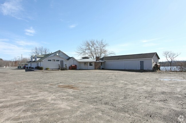
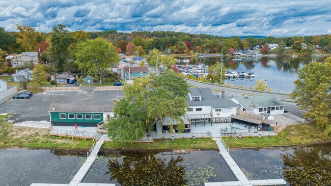
Property Record
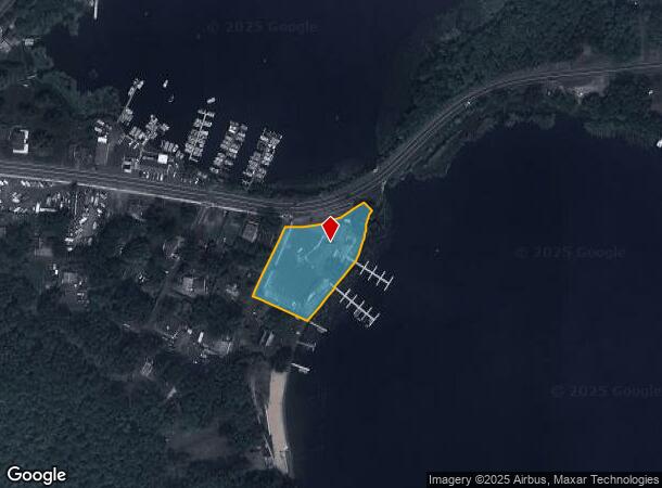
141 Congamond Rd, Southwick, MA 01077
NEARBY LISTINGS FOR SALE OR LEASE
-
-
View all Southwick listings for lease on LoopNet.com
Property Detail
141 Congamond Rd
SWIC-000149-000000-000001
Hampden
Restaurantbuilding
Massachusetts
AE
1
25013C0369E
1.20 AC
2025
Hampden County
2025
Hartford
813101
Springfield, MA
4,747 SF
DEMOGRAPHICS near 141 Congamond Rd
1 Mile
3 Mile
5 Mile
2024 Total Population
2,102
9,389
24,028
2029 Population
2,089
9,307
23,810
Pop Growth 2024-2029
(0.62%)
(0.87%)
(0.91%)
Average Age
44
44
44
2024 Total Households
866
3,839
9,532
HH Growth 2024-2029
(0.69%)
(0.96%)
(1.00%)
Median Household Inc
$105,492
$105,792
$110,646
Avg Household Size
2.40
2.40
2.50
2024 Avg HH Vehicles
2.00
2.00
2.00
Median Home Value
$401,807
$350,905
$341,961
Median Year Built
1973
1974
1975
Nearby Places
Map Layers
Map Styles
 Street
 Aerial
- Restaurants
- Banks
- Shops
- Fitness
- Groceries
PUBLIC TRANSPORTATION
AIRPORT
Bradley International
DRIVE
WALK
Distance
Bradley International
27 min
11.2 mi
SALE & LEASE HISTORY
LISTING DATE
SALE/LEASE

Oct 26, 2023
For Lease
Oct 17, 2023
For Sale
Aug 24, 2018
For Sale
Nearby Properties
Address
Land Use
TOTAL SIZE
Lot Size
Zoning
Address
Land Use
TOTAL SIZE
Lot Size
Zoning
4,628 SF
16.01 AC
R-20
Address
Land Use
TOTAL SIZE
Lot Size
Zoning
27,730 SF
17 AC
BR
Address
Land Use
TOTAL SIZE
Lot Size
Zoning
58,477 SF
14.99 AC
R30
Address
Land Use
TOTAL SIZE
Lot Size
Zoning
2,684 SF
17.01 AC
BR
Address
Land Use
TOTAL SIZE
Lot Size
Zoning
57,159 SF
7.07 AC
B
Address
Land Use
TOTAL SIZE
Lot Size
Zoning
31,216 SF
9.20 AC
I
Address
Land Use
TOTAL SIZE
Lot Size
Zoning
2,183 SF
5.59 AC
BR
Address
Land Use
TOTAL SIZE
Lot Size
Zoning
5,501 SF
7.70 AC
R-20
Address
Land Use
TOTAL SIZE
Lot Size
Zoning
45,840 SF
3.46 AC
B
Address
Land Use
TOTAL SIZE
Lot Size
Zoning
12.98 AC
I
Address
Land Use
TOTAL SIZE
Lot Size
Zoning
12.98 AC
Address
Land Use
TOTAL SIZE
Lot Size
Zoning
11,304 SF
0.52 AC
BR
Address
Land Use
TOTAL SIZE
Lot Size
Zoning
12,847 SF
2.25 AC
B
Address
Land Use
TOTAL SIZE
Lot Size
Zoning
9,574 SF
5.80 AC
R-40
Address
Land Use
TOTAL SIZE
Lot Size
Zoning
1,819 SF
3.45 AC
B
Address
Land Use
TOTAL SIZE
Lot Size
Zoning
10,655 SF
1.43 AC
BR
Address
Land Use
TOTAL SIZE
Lot Size
Zoning
10,900 SF
6.97 AC
NC
Address
Land Use
TOTAL SIZE
Lot Size
Zoning
160.37 AC
FP
Address
Land Use
TOTAL SIZE
Lot Size
Zoning
35,478 SF
3.10 AC
BR
Address
Land Use
TOTAL SIZE
Lot Size
Zoning
9,992 SF
31.41 AC
R-40
Address
Land Use
TOTAL SIZE
Lot Size
Zoning
2.20 AC
NC
Address
Land Use
TOTAL SIZE
Lot Size
Zoning
2.89 AC
R30
Address
Land Use
TOTAL SIZE
Lot Size
Zoning
5.16 AC
I
Address
Land Use
TOTAL SIZE
Lot Size
Zoning
5,568 SF
5.51 AC
R-40
Address
Land Use
TOTAL SIZE
Lot Size
Zoning
3,616 SF
1.70 AC
R-40
Address
Land Use
TOTAL SIZE
Lot Size
Zoning
18,373 SF
2.40 AC
BR
Address
Land Use
TOTAL SIZE
Lot Size
Zoning
4,015 SF
1.11 AC
B
Address
Land Use
TOTAL SIZE
Lot Size
Zoning
134.68 AC
R90
Address
Land Use
TOTAL SIZE
Lot Size
Zoning
10,537 SF
6.40 AC
BR
Address
Land Use
TOTAL SIZE
Lot Size
Zoning
5,000 SF
3.36 AC
I
The World's #1 Commercial Real Estate Marketplace
Connect with us
© 2025 CoStar Group
The information above has been obtained from sources believed reliable. While we do not doubt its accuracy we have not verified it and make no guarantee, warranty or representation about it. It is your responsibility to independently confirm its accuracy and completeness. Any projections, opinions, assumptions, or estimates used are for example only and do not represent the current or future performance of the property. The value of this transaction to you depends on tax and other factors which should be evaluated by your tax, financial, and legal advisors. You and your advisors should conduct a careful, independent investigation of the property to determine to your satisfaction the suitability of the property for your needs.