Property Record
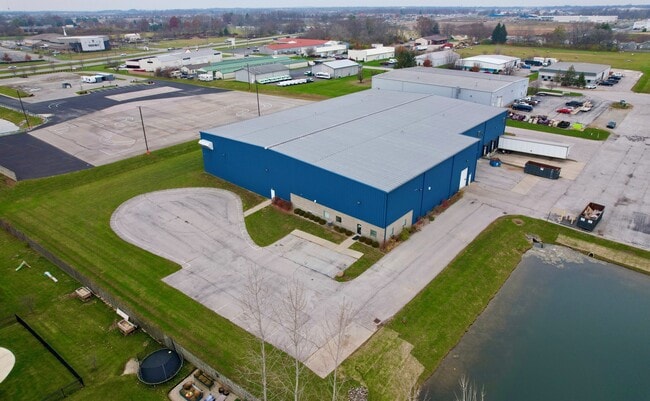
141 Crossroads Dr, Whiteland, IN 46184

This Property Is For Sale
Current Lease Availabilities
NEARBY LISTINGS FOR SALE OR LEASE
Property Detail
141 Crossroads Dr
41-05-16-021-024.000-030
Midwest Bus Center
Warehouse
MIDWEST BUSINESS CENTER - EXPANSION OF PT BLOCK B
X
Johnson
18081C0128D
Indiana
2024
2.01 AC
2025
Johnson County
610102
Indianapolis
30,350 SF
Indianapolis-Carmel-Greenwood, IN
DEMOGRAPHICS near 141 Crossroads Dr
1 Mile
3 Mile
5 Mile
2024 Total Population
6,993
49,355
104,491
2029 Population
7,429
52,694
110,640
Pop Growth 2024-2029
+ 6.23%
+ 6.77%
+ 5.88%
Average Age
35
38
38
2024 Total Households
2,369
18,643
40,080
HH Growth 2024-2029
+ 6.42%
+ 6.96%
+ 5.95%
Median Household Inc
$81,041
$78,375
$75,025
Avg Household Size
2.90
2.60
2.60
2024 Avg HH Vehicles
2.00
2.00
2.00
Median Home Value
$207,287
$193,341
$214,994
Median Year Built
2001
1995
1993
Nearby Places
Map Layers
Map Styles
 Street
 Aerial
- Restaurants
- Banks
- Shops
- Fitness
- Groceries
PUBLIC TRANSPORTATION
AIRPORT
Indianapolis International
DRIVE
WALK
Distance
Indianapolis International
40 min
23.6 mi
Freight Ports
Port of Toledo
DRIVE
WALK
Distance
Port of Toledo
289 min
238.9 mi
Nearby Properties
Address
Land Use
TOTAL SIZE
Lot Size
Zoning
Address
Land Use
TOTAL SIZE
Lot Size
Zoning
1,057,350 SF
60.62 AC
Address
Land Use
TOTAL SIZE
Lot Size
Zoning
845,880 SF
45.31 AC
Address
Land Use
TOTAL SIZE
Lot Size
Zoning
997,650 SF
67.25 AC
Address
Land Use
TOTAL SIZE
Lot Size
Zoning
816,376 SF
65.10 AC
Address
Land Use
TOTAL SIZE
Lot Size
Zoning
826,800 SF
62.89 AC
Address
Land Use
TOTAL SIZE
Lot Size
Zoning
615,440 SF
78.64 AC
Address
Land Use
TOTAL SIZE
Lot Size
Zoning
34.59 AC
Address
Land Use
TOTAL SIZE
Lot Size
Zoning
799,575 SF
37.56 AC
Address
Land Use
TOTAL SIZE
Lot Size
Zoning
39,866 SF
19.99 AC
Address
Land Use
TOTAL SIZE
Lot Size
Zoning
446,500 SF
45.43 AC
Address
Land Use
TOTAL SIZE
Lot Size
Zoning
581,612 SF
33.53 AC
Address
Land Use
TOTAL SIZE
Lot Size
Zoning
32.60 AC
Address
Land Use
TOTAL SIZE
Lot Size
Zoning
470,000 SF
22.75 AC
Address
Land Use
TOTAL SIZE
Lot Size
Zoning
1,968 SF
37.45 AC
Address
Land Use
TOTAL SIZE
Lot Size
Zoning
612,000 SF
31.01 AC
Address
Land Use
TOTAL SIZE
Lot Size
Zoning
4,027 SF
24.71 AC
Address
Land Use
TOTAL SIZE
Lot Size
Zoning
4,722 SF
25.71 AC
Address
Land Use
TOTAL SIZE
Lot Size
Zoning
146,716 SF
25.43 AC
Address
Land Use
TOTAL SIZE
Lot Size
Zoning
2,480 SF
14.45 AC
Address
Land Use
TOTAL SIZE
Lot Size
Zoning
290,258 SF
21.37 AC
Address
Land Use
TOTAL SIZE
Lot Size
Zoning
176,228 SF
1.57 AC
Address
Land Use
TOTAL SIZE
Lot Size
Zoning
56,100 SF
50.05 AC
Address
Land Use
TOTAL SIZE
Lot Size
Zoning
342,627 SF
69.52 AC
Address
Land Use
TOTAL SIZE
Lot Size
Zoning
8.88 AC
Address
Land Use
TOTAL SIZE
Lot Size
Zoning
69,444 SF
2.99 AC
Address
Land Use
TOTAL SIZE
Lot Size
Zoning
6,272 SF
21.91 AC
Address
Land Use
TOTAL SIZE
Lot Size
Zoning
449,200 SF
17.02 AC
Address
Land Use
TOTAL SIZE
Lot Size
Zoning
2,008 SF
9.86 AC
Address
Land Use
TOTAL SIZE
Lot Size
Zoning
1,951 SF
26.87 AC
Address
Land Use
TOTAL SIZE
Lot Size
Zoning
3,406 SF
20.34 AC
The World's #1 Commercial Real Estate Marketplace
Connect with us
© 2026 CoStar Group
The information above has been obtained from sources believed reliable. While we do not doubt its accuracy we have not verified it and make no guarantee, warranty or representation about it. It is your responsibility to independently confirm its accuracy and completeness. Any projections, opinions, assumptions, or estimates used are for example only and do not represent the current or future performance of the property. The value of this transaction to you depends on tax and other factors which should be evaluated by your tax, financial, and legal advisors. You and your advisors should conduct a careful, independent investigation of the property to determine to your satisfaction the suitability of the property for your needs.