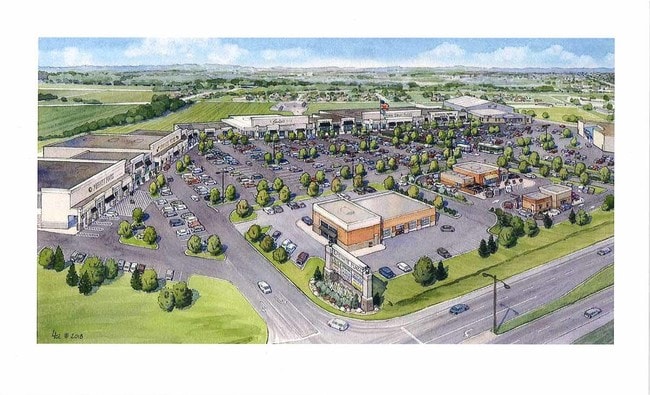
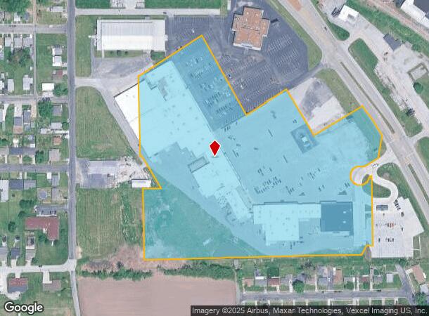
Property Record
141 Eastgate Plz, East Alton, IL 62024
NEARBY LISTINGS FOR SALE OR LEASE
Property Detail
141 Eastgate Plz
19-1-08-17-20-401-002
Madison
Restaurantbuilding
Illinois
2024
16.80 AC
2024
NE Metro Illinois
401300
St. Louis
576 SF
St. Louis, MO-IL
DEMOGRAPHICS near 141 Eastgate Plz
1 Mile
3 Mile
5 Mile
2024 Total Population
4,542
34,319
63,378
2029 Population
4,517
34,106
62,937
Pop Growth 2024-2029
(0.55%)
(0.62%)
(0.70%)
Average Age
42
41
41
2024 Total Households
2,024
14,898
27,457
HH Growth 2024-2029
(0.59%)
(0.68%)
(0.75%)
Median Household Inc
$45,467
$53,027
$55,424
Avg Household Size
2.20
2.20
2.20
2024 Avg HH Vehicles
2.00
2.00
2.00
Median Home Value
$68,414
$87,066
$103,941
Median Year Built
1953
1953
1956
Nearby Places
Map Layers
Map Styles
 Street
 Aerial
- Restaurants
- Banks
- Shops
- Fitness
- Groceries
PUBLIC TRANSPORTATION
COMMUTER RAIL
Alton Amtrak Station (Lincoln Service - Amtrak, Lincoln Service Missouri River Runner - Amtrak, Texas Eagle - Amtrak)
DRIVE
WALK
Distance
Alton Amtrak Station (Lincoln Service - Amtrak, Lincoln Service Missouri River Runner - Amtrak, Texas Eagle - Amtrak)
9 min
4.7 mi
AIRPORT
St Louis Lambert International
DRIVE
WALK
Distance
St Louis Lambert International
32 min
23.2 mi
Scott AFB/Midamerica St Louis
DRIVE
WALK
Distance
Scott AFB/Midamerica St Louis
58 min
40.4 mi
Freight Ports
Port Milwaukee
DRIVE
WALK
Distance
Port Milwaukee
411 min
356.1 mi
Nearby Properties
Address
Land Use
TOTAL SIZE
Lot Size
Zoning
Address
Land Use
TOTAL SIZE
Lot Size
Zoning
16.61 AC
Address
Land Use
TOTAL SIZE
Lot Size
Zoning
59.04 AC
Address
Land Use
TOTAL SIZE
Lot Size
Zoning
Address
Land Use
TOTAL SIZE
Lot Size
Zoning
215,635 SF
23.08 AC
Address
Land Use
TOTAL SIZE
Lot Size
Zoning
Address
Land Use
TOTAL SIZE
Lot Size
Zoning
58,990 SF
11.77 AC
Address
Land Use
TOTAL SIZE
Lot Size
Zoning
26.24 AC
Address
Land Use
TOTAL SIZE
Lot Size
Zoning
37,533 SF
7.80 AC
Address
Land Use
TOTAL SIZE
Lot Size
Zoning
87,624 SF
4.28 AC
Address
Land Use
TOTAL SIZE
Lot Size
Zoning
75,312 SF
4.35 AC
Address
Land Use
TOTAL SIZE
Lot Size
Zoning
6,146 SF
9 AC
Address
Land Use
TOTAL SIZE
Lot Size
Zoning
4,800 SF
39.15 AC
Address
Land Use
TOTAL SIZE
Lot Size
Zoning
20,000 SF
10.81 AC
Address
Land Use
TOTAL SIZE
Lot Size
Zoning
64,260 SF
3.90 AC
Address
Land Use
TOTAL SIZE
Lot Size
Zoning
334.25 AC
AA9
Address
Land Use
TOTAL SIZE
Lot Size
Zoning
330.54 AC
Address
Land Use
TOTAL SIZE
Lot Size
Zoning
155,147 SF
14.37 AC
Address
Land Use
TOTAL SIZE
Lot Size
Zoning
3,600 SF
59.53 AC
Address
Land Use
TOTAL SIZE
Lot Size
Zoning
38,517 SF
4.10 AC
Address
Land Use
TOTAL SIZE
Lot Size
Zoning
2,700 SF
11.77 AC
Address
Land Use
TOTAL SIZE
Lot Size
Zoning
39.31 AC
Address
Land Use
TOTAL SIZE
Lot Size
Zoning
29,491 SF
2 AC
Address
Land Use
TOTAL SIZE
Lot Size
Zoning
17,760 SF
2.72 AC
Address
Land Use
TOTAL SIZE
Lot Size
Zoning
26,320 SF
4.82 AC
Address
Land Use
TOTAL SIZE
Lot Size
Zoning
23,918 SF
1.26 AC
Address
Land Use
TOTAL SIZE
Lot Size
Zoning
6,510 SF
2.57 AC
Address
Land Use
TOTAL SIZE
Lot Size
Zoning
10,440 SF
1.91 AC
Address
Land Use
TOTAL SIZE
Lot Size
Zoning
4,380 SF
8.25 AC
Address
Land Use
TOTAL SIZE
Lot Size
Zoning
89,691 SF
7.78 AC
The World's #1 Commercial Real Estate Marketplace
Connect with us
© 2026 CoStar Group
The information above has been obtained from sources believed reliable. While we do not doubt its accuracy we have not verified it and make no guarantee, warranty or representation about it. It is your responsibility to independently confirm its accuracy and completeness. Any projections, opinions, assumptions, or estimates used are for example only and do not represent the current or future performance of the property. The value of this transaction to you depends on tax and other factors which should be evaluated by your tax, financial, and legal advisors. You and your advisors should conduct a careful, independent investigation of the property to determine to your satisfaction the suitability of the property for your needs.