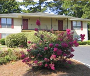
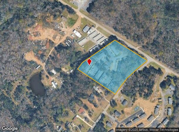
Property Record
141 Frank Bone Rd Sw, Milledgeville, GA 31061
NEARBY LISTINGS FOR SALE OR LEASE
-
-
View all Milledgeville listings for sale on LoopNet.com
Property Detail
141 Frank Bone Rd Sw
Milledgeville, GA
Comm-Frank Bone-North
070-023
LTS 1-5 BRK-RIDGE DB731-201 PB11/156
Apartment
Baldwin
X
Georgia
13319C0025C
1-5
2025
5.50 AC
2025
Georgia South Area
970600
Other Market Areas
435,152 SF
DEMOGRAPHICS near 141 Frank Bone Rd Sw
1 Mile
3 Mile
5 Mile
2024 Total Population
4,392
19,843
26,268
2029 Population
4,356
19,919
26,234
Pop Growth 2024-2029
(0.82%)
+ 0.38%
(0.13%)
Average Age
33
37
38
2024 Total Households
1,602
7,710
10,010
HH Growth 2024-2029
(1.44%)
+ 0.38%
(0.16%)
Median Household Inc
$22,920
$33,082
$37,983
Avg Household Size
2.10
2.20
2.30
2024 Avg HH Vehicles
2.00
2.00
2.00
Median Home Value
$138,725
$124,034
$144,800
Median Year Built
1984
1976
1978
Nearby Places
Map Layers
Map Styles
 Street
 Aerial
- Restaurants
- Banks
- Shops
- Fitness
- Groceries
Nearby Properties
Address
Land Use
TOTAL SIZE
Lot Size
Zoning
Address
Land Use
TOTAL SIZE
Lot Size
Zoning
19.20 AC
RESIDENTIA
Address
Land Use
TOTAL SIZE
Lot Size
Zoning
29.65 AC
RESIDENTIA
Address
Land Use
TOTAL SIZE
Lot Size
Zoning
102,300 SF
66.81 AC
UNZONED RU
Address
Land Use
TOTAL SIZE
Lot Size
Zoning
69,820 SF
15 AC
COMMERCIAL
Address
Land Use
TOTAL SIZE
Lot Size
Zoning
5,378 SF
1,875.54 AC
RESIDENTIA
Address
Land Use
TOTAL SIZE
Lot Size
Zoning
31,112 SF
13.98 AC
RESIDENTIA
Address
Land Use
TOTAL SIZE
Lot Size
Zoning
59,500 SF
44 AC
RESIDENTIA
Address
Land Use
TOTAL SIZE
Lot Size
Zoning
74,448 SF
49 AC
RESIDENTIA
Address
Land Use
TOTAL SIZE
Lot Size
Zoning
118,521 SF
1.86 AC
RESIDENTIA
Address
Land Use
TOTAL SIZE
Lot Size
Zoning
34,953 SF
2.17 AC
RESIDENTIA
Address
Land Use
TOTAL SIZE
Lot Size
Zoning
2.50 AC
RESIDENTIA
Address
Land Use
TOTAL SIZE
Lot Size
Zoning
49,412 SF
0.26 AC
RESIDENTIA
Address
Land Use
TOTAL SIZE
Lot Size
Zoning
313,804 SF
17.50 AC
RESIDENTIA
Address
Land Use
TOTAL SIZE
Lot Size
Zoning
386,880 SF
17.52 AC
RESIDENTIA
Address
Land Use
TOTAL SIZE
Lot Size
Zoning
219,384 SF
24.68 AC
Address
Land Use
TOTAL SIZE
Lot Size
Zoning
67,500 SF
1.70 AC
RESIDENTIA
Address
Land Use
TOTAL SIZE
Lot Size
Zoning
30.05 AC
RESIDENTIA
Address
Land Use
TOTAL SIZE
Lot Size
Zoning
866,082 SF
6.61 AC
RESIDENTIA
Address
Land Use
TOTAL SIZE
Lot Size
Zoning
40,800 SF
0.14 AC
RESIDENTIA
Address
Land Use
TOTAL SIZE
Lot Size
Zoning
12.30 AC
RESIDENTIA
Address
Land Use
TOTAL SIZE
Lot Size
Zoning
70,460 SF
14.93 AC
COMMERCIAL
Address
Land Use
TOTAL SIZE
Lot Size
Zoning
127,410 SF
25.98 AC
RESIDENTIA
Address
Land Use
TOTAL SIZE
Lot Size
Zoning
228,844 SF
3.20 AC
RESIDENTIA
Address
Land Use
TOTAL SIZE
Lot Size
Zoning
554,286 SF
24.17 AC
RESIDENTIA
Address
Land Use
TOTAL SIZE
Lot Size
Zoning
19.50 AC
RESIDENTIA
Address
Land Use
TOTAL SIZE
Lot Size
Zoning
139,950 SF
27.92 AC
RESIDENTIA
Address
Land Use
TOTAL SIZE
Lot Size
Zoning
46,858 SF
2.64 AC
RESIDENTIA
Address
Land Use
TOTAL SIZE
Lot Size
Zoning
76,582 SF
3.17 AC
RESIDENTIA
Address
Land Use
TOTAL SIZE
Lot Size
Zoning
71,162 SF
2.30 AC
COMMERCIAL
Address
Land Use
TOTAL SIZE
Lot Size
Zoning
160,604 SF
8.29 AC
RESIDENTIA
The World's #1 Commercial Real Estate Marketplace
Connect with us
© 2026 CoStar Group
The information above has been obtained from sources believed reliable. While we do not doubt its accuracy we have not verified it and make no guarantee, warranty or representation about it. It is your responsibility to independently confirm its accuracy and completeness. Any projections, opinions, assumptions, or estimates used are for example only and do not represent the current or future performance of the property. The value of this transaction to you depends on tax and other factors which should be evaluated by your tax, financial, and legal advisors. You and your advisors should conduct a careful, independent investigation of the property to determine to your satisfaction the suitability of the property for your needs.