Property Record
141 Howard St, Braintree, MA 02184

NEARBY LISTINGS FOR SALE OR LEASE
Property Detail
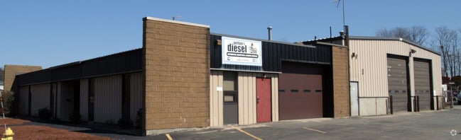
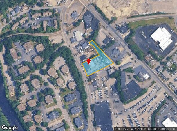
141 Howard St
BRAI-003049-000000-000002D
Norfolk
Commercialbuilding
Massachusetts
X
2d
25021C0226G
0.99 AC
2025
Quincy/Braintree
2025
Boston
419400
Boston-Cambridge-Newton, MA-NH
7,484 SF
DEMOGRAPHICS near 141 Howard St
1 Mile
3 Mile
5 Mile
2024 Total Population
19,614
121,017
225,773
2029 Population
19,289
120,108
224,525
Pop Growth 2024-2029
(1.66%)
(0.75%)
(0.55%)
Average Age
42
41
42
2024 Total Households
8,829
51,600
93,862
HH Growth 2024-2029
(1.86%)
(0.73%)
(0.53%)
Median Household Inc
$81,935
$91,768
$98,076
Avg Household Size
2.20
2.30
2.30
2024 Avg HH Vehicles
1.00
2.00
2.00
Median Home Value
$564,734
$552,806
$596,497
Median Year Built
1959
1957
1959
Nearby Places
Map Layers
Map Styles
 Street
 Aerial
- Restaurants
- Banks
- Shops
- Fitness
- Groceries
PUBLIC TRANSPORTATION
COMMUTER RAIL
Weymouth Landing/East Braintree (Greenbush Line - MBTA)
DRIVE
WALK
Distance
Weymouth Landing/East Braintree (Greenbush Line - MBTA)
4 min
1.4 mi
Quincy Center Station (Greenbush Line - Massachusetts Bay Transportation Authority Commuter Rail (Purple Line), Kingston/Plymouth Line - Massachusetts Bay Transportation Authority Commuter Rail (Purple Line), Middleborough/Lakeville Line - Massachusetts Bay Transportation Authority Commuter Rail (Purple Line), Red Line - Massachusetts Bay Transportation Authority Commuter Rail (Purple Line))
DRIVE
WALK
Distance
Quincy Center Station (Greenbush Line - Massachusetts Bay Transportation Authority Commuter Rail (Purple Line), Kingston/Plymouth Line - Massachusetts Bay Transportation Authority Commuter Rail (Purple Line), Middleborough/Lakeville Line - Massachusetts Bay Transportation Authority Commuter Rail (Purple Line), Red Line - Massachusetts Bay Transportation Authority Commuter Rail (Purple Line))
4 min
2.1 mi
AIRPORT
General Edward Lawrence Logan International
DRIVE
WALK
Distance
General Edward Lawrence Logan International
24 min
14.1 mi
Freight Ports
Port of Boston
DRIVE
WALK
Distance
Port of Boston
22 min
12.0 mi
SALE & LEASE HISTORY
LISTING DATE
SALE/LEASE

Mar 28, 2019
For Sale
Jan 17, 2020
For Lease
Jan 08, 2019
For Sale
Nearby Properties
Address
Land Use
TOTAL SIZE
Lot Size
Zoning
Address
Land Use
TOTAL SIZE
Lot Size
Zoning
148,456 SF
0.43 AC
Address
Land Use
TOTAL SIZE
Lot Size
Zoning
50.61 AC
IND
Address
Land Use
TOTAL SIZE
Lot Size
Zoning
17.33 AC
Address
Land Use
TOTAL SIZE
Lot Size
Zoning
20,596 SF
16.20 AC
PUD
Address
Land Use
TOTAL SIZE
Lot Size
Zoning
3.31 AC
BUSC
Address
Land Use
TOTAL SIZE
Lot Size
Zoning
236,154 SF
1.41 AC
BUSC
Address
Land Use
TOTAL SIZE
Lot Size
Zoning
14.81 AC
Address
Land Use
TOTAL SIZE
Lot Size
Zoning
15.81 AC
Address
Land Use
TOTAL SIZE
Lot Size
Zoning
33.81 AC
A3
Address
Land Use
TOTAL SIZE
Lot Size
Zoning
9.10 AC
RESC
Address
Land Use
TOTAL SIZE
Lot Size
Zoning
202,858 SF
2.30 AC
Address
Land Use
TOTAL SIZE
Lot Size
Zoning
5.06 AC
BUSC
Address
Land Use
TOTAL SIZE
Lot Size
Zoning
233,488 SF
9.82 AC
Address
Land Use
TOTAL SIZE
Lot Size
Zoning
38.48 AC
B
Address
Land Use
TOTAL SIZE
Lot Size
Zoning
132,997 SF
1.45 AC
Address
Land Use
TOTAL SIZE
Lot Size
Zoning
147,611 SF
0.62 AC
BUSC
Address
Land Use
TOTAL SIZE
Lot Size
Zoning
11.90 AC
PUD
Address
Land Use
TOTAL SIZE
Lot Size
Zoning
237,086 SF
15 AC
INDB
Address
Land Use
TOTAL SIZE
Lot Size
Zoning
133,254 SF
4.21 AC
Address
Land Use
TOTAL SIZE
Lot Size
Zoning
240,481 SF
25.23 AC
CL2
Address
Land Use
TOTAL SIZE
Lot Size
Zoning
124,274 SF
0.62 AC
Address
Land Use
TOTAL SIZE
Lot Size
Zoning
10.38 AC
Address
Land Use
TOTAL SIZE
Lot Size
Zoning
233,530 SF
6.70 AC
PUD
Address
Land Use
TOTAL SIZE
Lot Size
Zoning
24,156 SF
7.65 AC
RESB
Address
Land Use
TOTAL SIZE
Lot Size
Zoning
134,342 SF
1.03 AC
BUSC
Address
Land Use
TOTAL SIZE
Lot Size
Zoning
5.38 AC
Address
Land Use
TOTAL SIZE
Lot Size
Zoning
172,027 SF
3.73 AC
100
Address
Land Use
TOTAL SIZE
Lot Size
Zoning
617,116 SF
79.59 AC
INDB
Address
Land Use
TOTAL SIZE
Lot Size
Zoning
204,944 SF
3.83 AC
Address
Land Use
TOTAL SIZE
Lot Size
Zoning
3,375 SF
12.03 AC
PUD
The World's #1 Commercial Real Estate Marketplace
Connect with us
© 2025 CoStar Group
The information above has been obtained from sources believed reliable. While we do not doubt its accuracy we have not verified it and make no guarantee, warranty or representation about it. It is your responsibility to independently confirm its accuracy and completeness. Any projections, opinions, assumptions, or estimates used are for example only and do not represent the current or future performance of the property. The value of this transaction to you depends on tax and other factors which should be evaluated by your tax, financial, and legal advisors. You and your advisors should conduct a careful, independent investigation of the property to determine to your satisfaction the suitability of the property for your needs.