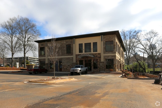
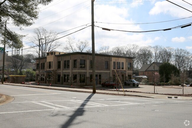
Property Record
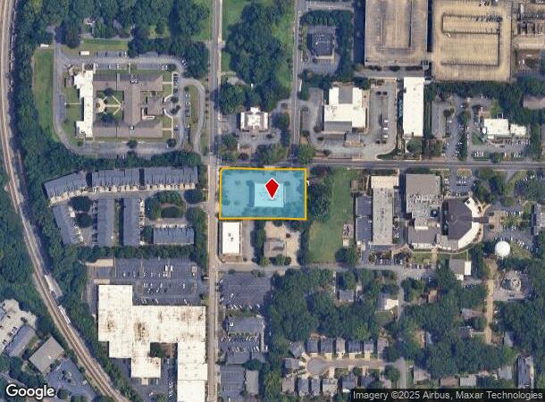
141 Lacy St Nw, Marietta, GA 30060
NEARBY LISTINGS FOR SALE OR LEASE
Property Detail
141 Lacy St Nw
Atlanta-Sandy Springs-Roswell, GA
Robert C Suhr Prop
16-1086-0-017-0
ALL THAT TRACT OR PARCEL OF LAND LYING AND BEING IN THE 16TH DISTRICT, 2ND SECTION, COBB COUNTY, GEORGIA, LYING WITHIN LAND
Officebuilding
Cobb
X
Georgia
13067C0108J
1086
2025
1.30 AC
2025
Kennesaw/Town Center
030602
Atlanta
16,160 SF
DEMOGRAPHICS near 141 Lacy St Nw
1 Mile
3 Mile
5 Mile
2024 Total Population
7,176
63,442
182,151
2029 Population
7,367
64,930
186,053
Pop Growth 2024-2029
+ 2.66%
+ 2.35%
+ 2.14%
Average Age
45
38
38
2024 Total Households
2,951
25,483
70,604
HH Growth 2024-2029
+ 2.78%
+ 2.35%
+ 2.17%
Median Household Inc
$76,254
$74,798
$74,302
Avg Household Size
2.20
2.30
2.40
2024 Avg HH Vehicles
2.00
2.00
2.00
Median Home Value
$455,192
$357,071
$340,478
Median Year Built
1979
1987
1986
Nearby Places
Map Layers
Map Styles
 Street
 Aerial
- Restaurants
- Banks
- Shops
- Fitness
- Groceries
PUBLIC TRANSPORTATION
AIRPORT
Hartsfield - Jackson Atlanta International
DRIVE
WALK
Distance
Hartsfield - Jackson Atlanta International
42 min
30.5 mi
Freight Ports
Georgia Ports - Savannah
DRIVE
WALK
Distance
Georgia Ports - Savannah
305 min
269.8 mi
SALE & LEASE HISTORY
LISTING DATE
SALE/LEASE

Sep 25, 2016
For Lease
Nearby Properties
Address
Land Use
TOTAL SIZE
Lot Size
Zoning
Address
Land Use
TOTAL SIZE
Lot Size
Zoning
379,750 SF
11.14 AC
Address
Land Use
TOTAL SIZE
Lot Size
Zoning
578,456 SF
60 AC
RM-12
Address
Land Use
TOTAL SIZE
Lot Size
Zoning
449,337 SF
53.52 AC
RM-12
Address
Land Use
TOTAL SIZE
Lot Size
Zoning
507,196 SF
67.83 AC
RM-12
Address
Land Use
TOTAL SIZE
Lot Size
Zoning
385,954 SF
31 AC
RM-12
Address
Land Use
TOTAL SIZE
Lot Size
Zoning
304,376 SF
19.86 AC
RM-12/WS
Address
Land Use
TOTAL SIZE
Lot Size
Zoning
283,134 SF
13.10 AC
PVC
Address
Land Use
TOTAL SIZE
Lot Size
Zoning
245,066 SF
15.41 AC
UC
Address
Land Use
TOTAL SIZE
Lot Size
Zoning
272,064 SF
22.59 AC
RM-12
Address
Land Use
TOTAL SIZE
Lot Size
Zoning
183,262 SF
19.35 AC
RM-12
Address
Land Use
TOTAL SIZE
Lot Size
Zoning
8,000 SF
9.57 AC
PRD MF
Address
Land Use
TOTAL SIZE
Lot Size
Zoning
284,832 SF
19.56 AC
PRD MF
Address
Land Use
TOTAL SIZE
Lot Size
Zoning
243,574 SF
40.05 AC
RM-8
Address
Land Use
TOTAL SIZE
Lot Size
Zoning
218,895 SF
8.10 AC
PVC
Address
Land Use
TOTAL SIZE
Lot Size
Zoning
129,168 SF
0.82 AC
OI
Address
Land Use
TOTAL SIZE
Lot Size
Zoning
284,213 SF
19.85 AC
RM-12
Address
Land Use
TOTAL SIZE
Lot Size
Zoning
226,769 SF
13.40 AC
RM-16
Address
Land Use
TOTAL SIZE
Lot Size
Zoning
222,906 SF
18.96 AC
RM-12
Address
Land Use
TOTAL SIZE
Lot Size
Zoning
225,728 SF
8.11 AC
PVC
Address
Land Use
TOTAL SIZE
Lot Size
Zoning
198,488 SF
16.79 AC
RM-12
Address
Land Use
TOTAL SIZE
Lot Size
Zoning
176,350 SF
19.56 AC
PRD MF
Address
Land Use
TOTAL SIZE
Lot Size
Zoning
143,362 SF
1.61 AC
OI
Address
Land Use
TOTAL SIZE
Lot Size
Zoning
325,227 SF
22.42 AC
RM-12
Address
Land Use
TOTAL SIZE
Lot Size
Zoning
13.17 AC
LI
Address
Land Use
TOTAL SIZE
Lot Size
Zoning
180,508 SF
21.88 AC
RM-8
Address
Land Use
TOTAL SIZE
Lot Size
Zoning
147,029 SF
3.05 AC
PRD MF
Address
Land Use
TOTAL SIZE
Lot Size
Zoning
200,134 SF
12.60 AC
RM-8
Address
Land Use
TOTAL SIZE
Lot Size
Zoning
188,789 SF
8.88 AC
PRD MF
Address
Land Use
TOTAL SIZE
Lot Size
Zoning
96,277 SF
15.22 AC
PVC
Address
Land Use
TOTAL SIZE
Lot Size
Zoning
The World's #1 Commercial Real Estate Marketplace
Connect with us
© 2025 CoStar Group
The information above has been obtained from sources believed reliable. While we do not doubt its accuracy we have not verified it and make no guarantee, warranty or representation about it. It is your responsibility to independently confirm its accuracy and completeness. Any projections, opinions, assumptions, or estimates used are for example only and do not represent the current or future performance of the property. The value of this transaction to you depends on tax and other factors which should be evaluated by your tax, financial, and legal advisors. You and your advisors should conduct a careful, independent investigation of the property to determine to your satisfaction the suitability of the property for your needs.