Property Record
141 Sw 6Th Ave, Oak Harbor, WA 98277
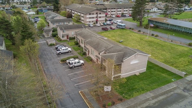


Property Detail
141 Sw 6Th Ave
R13203-367-5050
24 FREUND DC - BG 2013.1S OF NE CR SD DC W350 TPB W300 S152 E200 S303 TP N0*E30 OF NLN BROAD VW1 N89*E100 N0*E TPB EX W200 AF#154987 TGW BG NE CR SD DC S0*W2468.10 N89*W50TPB N89*W300 N0*E455S89*E335 S0*W46.70 N89*W35 S0*W 408.30 TPB EX
Multifamilydwelling
Island
OH
Washington
B and X Area of moderate flood hazard, usually the area between the limits of the 100-year and 500-year floods.
0.70 AC
2025
Seattle North/Everett
2025
Other Market Areas
970602
Oak Harbor, WA
14,332 SF
NEARBY LISTINGS FOR SALE OR LEASE
-
-
View all Oak Harbor listings for sale on LoopNet.com
DEMOGRAPHICS near 141 Sw 6Th Ave
1 mile
3 mile
5 mile
2025 Total Population
10,902
27,516
34,904
2030 Population
10,560
26,677
33,917
Pop Growth 2025-2030
(3.14%)
(3.05%)
(2.83%)
Average Age
39
37
38
2025 Total Households
4,659
10,191
12,972
HH Growth 2025-2030
(3.41%)
(3.33%)
(3.08%)
Median Household Inc
$71,374
$79,464
$83,350
Avg Household Size
2.30
2.50
2.50
2025 Avg HH Vehicles
2.00
2.00
2.00
Median Home Value
$426,757
$456,945
$482,638
Median Year Built
1983
1985
1985
Nearby Places
Map Layers
Map Styles
 Street
 Aerial
Transit
 Traffic
 Biking
Places
Listings with unknown addresses are not visible on the map
- Restaurants
- Banks
- Shops
- Fitness
- Groceries
PUBLIC TRANSPORTATION
AIRPORT
Seattle Paine Field International
Drive
Walk
Distance
Seattle Paine Field International
91 min
45.9 mi
Freight Ports
Drive
Walk
Distance
35 min
20.8 mi
SALE & LEASE HISTORY
LISTING DATE
SALE/LEASE

Apr 25, 2017
For Sale
Nearby Properties
Address
Land Use
TOTAL SIZE
Lot Size
Zoning
Address
Land Use
TOTAL SIZE
Lot Size
Zoning
273,742 SF
44.92 AC
OH
Address
Land Use
TOTAL SIZE
Lot Size
Zoning
83,018 SF
3.07 AC
OH
Address
Land Use
TOTAL SIZE
Lot Size
Zoning
121,642 SF
6.28 AC
OH
Address
Land Use
TOTAL SIZE
Lot Size
Zoning
94,005 SF
4.79 AC
OH
Address
Land Use
TOTAL SIZE
Lot Size
Zoning
87,878 SF
15.76 AC
OH
Address
Land Use
TOTAL SIZE
Lot Size
Zoning
70,705 SF
7.47 AC
OH
Address
Land Use
TOTAL SIZE
Lot Size
Zoning
19,160 SF
8.50 AC
50
Address
Land Use
TOTAL SIZE
Lot Size
Zoning
105,488 SF
11.32 AC
C-5
Address
Land Use
TOTAL SIZE
Lot Size
Zoning
101,703 SF
10.66 AC
OH
Address
Land Use
TOTAL SIZE
Lot Size
Zoning
57,924 SF
19.54 AC
OH
Address
Land Use
TOTAL SIZE
Lot Size
Zoning
41,845 SF
3.29 AC
OH
Address
Land Use
TOTAL SIZE
Lot Size
Zoning
24,800 SF
3.18 AC
OH
Address
Land Use
TOTAL SIZE
Lot Size
Zoning
27,618 SF
3.91 AC
OH
Address
Land Use
TOTAL SIZE
Lot Size
Zoning
41,180 SF
12.68 AC
OH
Address
Land Use
TOTAL SIZE
Lot Size
Zoning
84,128 SF
8.36 AC
50
Address
Land Use
TOTAL SIZE
Lot Size
Zoning
30,649 SF
3.14 AC
OH
Address
Land Use
TOTAL SIZE
Lot Size
Zoning
43,347 SF
2.04 AC
Address
Land Use
TOTAL SIZE
Lot Size
Zoning
39,068 SF
2.15 AC
OH
Address
Land Use
TOTAL SIZE
Lot Size
Zoning
32,776 SF
3.30 AC
OH
Address
Land Use
TOTAL SIZE
Lot Size
Zoning
15,512 SF
3.15 AC
OH
Address
Land Use
TOTAL SIZE
Lot Size
Zoning
75,050 SF
6.75 AC
Address
Land Use
TOTAL SIZE
Lot Size
Zoning
53,090 SF
1.71 AC
OH
Address
Land Use
TOTAL SIZE
Lot Size
Zoning
44,368 SF
4.53 AC
OH
Address
Land Use
TOTAL SIZE
Lot Size
Zoning
13,999 SF
1.47 AC
OH
Address
Land Use
TOTAL SIZE
Lot Size
Zoning
41,632 SF
2.41 AC
OH
Address
Land Use
TOTAL SIZE
Lot Size
Zoning
43,544 SF
57.54 AC
OH
Address
Land Use
TOTAL SIZE
Lot Size
Zoning
52,743 SF
2.20 AC
OH
The World's #1 Commercial Real Estate Marketplace
Connect with us
© 2026 CoStar Group
The information above has been obtained from sources believed reliable. While we do not doubt its accuracy we have not verified it and make no guarantee, warranty or representation about it. It is your responsibility to independently confirm its accuracy and completeness. Any projections, opinions, assumptions, or estimates used are for example only and do not represent the current or future performance of the property. The value of this transaction to you depends on tax and other factors which should be evaluated by your tax, financial, and legal advisors. You and your advisors should conduct a careful, independent investigation of the property to determine to your satisfaction the suitability of the property for your needs.