Property Record
141 Vinton Rd, Anthony, TX 79821
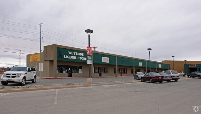
Property Detail
141 Vinton Rd
El Paso, TX
1 VINTON HILLS COMMERCIAL PARK #1 LOT 3 (62978.00 SQ FT)
V863-000-0010-0300
El Paso
Commercialnec
Texas
2024
3
2025
1.45 AC
010231
Outlying El Paso County
15,119 SF
El Paso
NEARBY LISTINGS FOR SALE OR LEASE
-
-
View all Anthony listings for sale on LoopNet.com
DEMOGRAPHICS near 141 Vinton Rd
1 mile
3 mile
5 mile
2024 Total Population
3,110
16,744
38,047
2029 Population
3,209
16,945
38,728
Pop Growth 2024-2029
+ 3.18%
+ 1.20%
+ 1.79%
Average Age
41
38
37
2024 Total Households
669
5,032
11,938
HH Growth 2024-2029
+ 3.74%
+ 1.21%
+ 1.86%
Median Household Inc
$65,484
$53,758
$58,444
Avg Household Size
3.20
3.10
3.10
2024 Avg HH Vehicles
3.00
2.00
2.00
Median Home Value
$153,694
$167,686
$207,021
Median Year Built
1993
1992
1995
Nearby Places
Map Layers
Map Styles
 Street
 Aerial
Transit
 Traffic
 Biking
Places
Listings with unknown addresses are not visible on the map
- Restaurants
- Banks
- Shops
- Fitness
- Groceries
PUBLIC TRANSPORTATION
AIRPORT
El Paso International
Drive
Walk
Distance
El Paso International
44 min
27.0 mi
SALE & LEASE HISTORY
LISTING DATE
SALE/LEASE

Mar 06, 2017
For Lease
Jun 26, 2023
For Sale
Apr 13, 2017
For Sale
Nearby Properties
Address
Land Use
TOTAL SIZE
Lot Size
Zoning
Address
Land Use
TOTAL SIZE
Lot Size
Zoning
241,312 SF
108.16 AC
Address
Land Use
TOTAL SIZE
Lot Size
Zoning
308,798 SF
44.59 AC
C1
Address
Land Use
TOTAL SIZE
Lot Size
Zoning
1 SF
2.39 AC
M1
Address
Land Use
TOTAL SIZE
Lot Size
Zoning
11,911 SF
13.67 AC
C1
Address
Land Use
TOTAL SIZE
Lot Size
Zoning
128,261 SF
52.29 AC
M2
Address
Land Use
TOTAL SIZE
Lot Size
Zoning
32,950 SF
35.70 AC
Address
Land Use
TOTAL SIZE
Lot Size
Zoning
28,213 SF
1.77 AC
Address
Land Use
TOTAL SIZE
Lot Size
Zoning
21,356 SF
23.42 AC
C1
Address
Land Use
TOTAL SIZE
Lot Size
Zoning
142,786 SF
54.77 AC
Address
Land Use
TOTAL SIZE
Lot Size
Zoning
17,780 SF
7.45 AC
C1
Address
Land Use
TOTAL SIZE
Lot Size
Zoning
53,714 SF
3.54 AC
Address
Land Use
TOTAL SIZE
Lot Size
Zoning
58,250 SF
5.13 AC
C4
Address
Land Use
TOTAL SIZE
Lot Size
Zoning
14,735 SF
1.85 AC
C1
Address
Land Use
TOTAL SIZE
Lot Size
Zoning
38,488 SF
37.19 AC
C1
Address
Land Use
TOTAL SIZE
Lot Size
Zoning
118,655 SF
14.53 AC
Address
Land Use
TOTAL SIZE
Lot Size
Zoning
80,382 SF
8 AC
Address
Land Use
TOTAL SIZE
Lot Size
Zoning
1 SF
Address
Land Use
TOTAL SIZE
Lot Size
Zoning
15,368 SF
12.45 AC
Address
Land Use
TOTAL SIZE
Lot Size
Zoning
18,020 SF
10 AC
Address
Land Use
TOTAL SIZE
Lot Size
Zoning
15,488 SF
3.98 AC
Address
Land Use
TOTAL SIZE
Lot Size
Zoning
42,836 SF
4.12 AC
C1
Address
Land Use
TOTAL SIZE
Lot Size
Zoning
Address
Land Use
TOTAL SIZE
Lot Size
Zoning
10,128 SF
1.30 AC
C3
Address
Land Use
TOTAL SIZE
Lot Size
Zoning
38,958 SF
6.30 AC
Address
Land Use
TOTAL SIZE
Lot Size
Zoning
52,954 SF
5.20 AC
Address
Land Use
TOTAL SIZE
Lot Size
Zoning
21,607 SF
1.25 AC
Address
Land Use
TOTAL SIZE
Lot Size
Zoning
4,800 SF
1.60 AC
Address
Land Use
TOTAL SIZE
Lot Size
Zoning
17,730 SF
17.67 AC
Address
Land Use
TOTAL SIZE
Lot Size
Zoning
9.73 AC
R3
Address
Land Use
TOTAL SIZE
Lot Size
Zoning
9,600 SF
1.10 AC
The World's #1 Commercial Real Estate Marketplace
Connect with us
© 2026 CoStar Group
The information above has been obtained from sources believed reliable. While we do not doubt its accuracy we have not verified it and make no guarantee, warranty or representation about it. It is your responsibility to independently confirm its accuracy and completeness. Any projections, opinions, assumptions, or estimates used are for example only and do not represent the current or future performance of the property. The value of this transaction to you depends on tax and other factors which should be evaluated by your tax, financial, and legal advisors. You and your advisors should conduct a careful, independent investigation of the property to determine to your satisfaction the suitability of the property for your needs.